East and the Horn of Africa
DTM East and the Horn of Africa
DTM Operations in the region
- Active DTM operation
- Past DTM operation
Between September and October 2022, the International Organization for Migration’s Displacement Tracking Matrix (IOM DTM) undertook its third household-level multi-sector assessment of selected urban areas and camps for internally displaced persons (IDPs) in South Sudan.

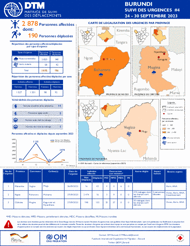
La DTM a identifié 2 878 personnes affectées dont 190 personnes déplacées par les vents violents et des pluies torrentielles dans les provinces de Makamba, Ngozi et Cibitoke.
Between September and October 2022, the International Organization for Migration’s Displacement Tracking Matrix (IOM DTM) undertook its third household-level multi-sector assessment of selected urban areas and camps for internally displaced persons (IDPs) in South Su
IOM’s Displacement Tracking Matrix is a comprehensive system to analyse and disseminate information to better understand the movements and needs of Internally Displaced Persons (IDPs) in Burundi.

Between September and October 2022, the International Organization for Migration’s Displacement Tracking Matrix (IOM DTM) undertook its third household-level multi-sector assessment of selected urban areas and camps for internally displaced persons (IDPs) in South Sudan.

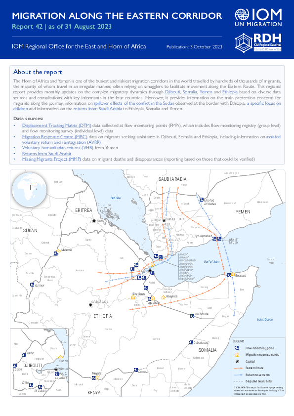
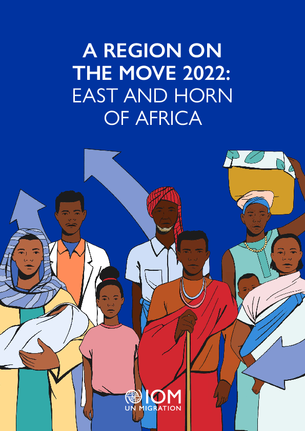
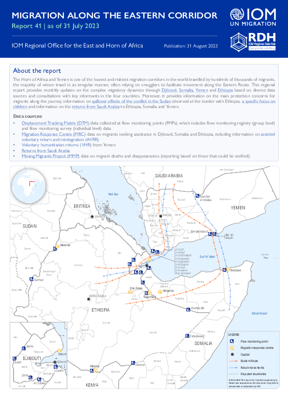
The Horn of Africa and Yemen is one of the busiest and riskiest migration corridors in the world travelled by hundreds of thousands of migrants, the majority of whom travel in an irregular manner, often relying on smugglers to facilitate movement along the Eastern Route.
This report presents a summary of the analysis of energy-related data based on the Mobility Tracking Round 11 of the DTM Multi-Sectoral Location Assessment (MLSA) in South Sudan.
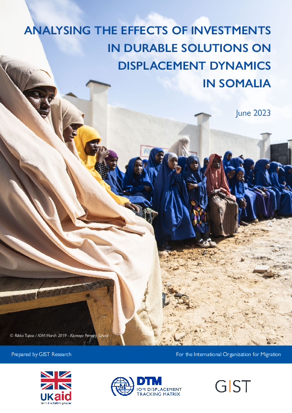
In 2022, DTM Somalia collaborated with GIST to implement a study aimed at understanding the key drivers of displacement during the drought crisis of that year.
La DTM a identifié 52 personnes affectées dont 12 personnes déplacées par les vents violents dans les province de Muyinga.

A total of 24,583 movements were observed in July 2023, representing 5 per cent increase compared to June 2023 when 23,383 movements were observed during this period.

This report presents findings on data collected by the International Organization for Migration (IOM), through its Displacement Tracking Matrix (DTM) methodology and Household-Level Intention Survey (HLIS) tool, to inform durable solutions activities for In

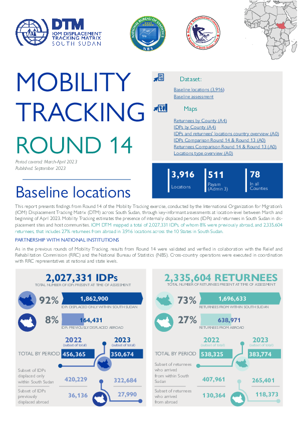
This summary presents initial findings from Round 14 of Mobility Tracking conducted across South Sudan through key-informant assessments at location-level in April 2023.
The 'A Region on the Move' report series for the East and Horn of Africa' has been the regional flagship publication since 2017.
A total of 23,383 movements were observed in June 2023, representing 10 per cent decrease compared to May 2023 when 26,003 movements were observed during this period.

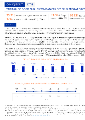
In August 2023, 25,213 migratory movements were observed at flow monitoring points (FMP) in Dijibouti, with a daily average of 813 migratory movements. Migration flows observed across all FMPs increased by 17% in August compared to July 2023 during which 21,573 movements were recorded.
En août 2023, 25 213 mouvements migratoires ont été observés aux points de suivi des flux (FMP) à Dijibouti, avec une moyenne quotidienne de 813 mouvements migratoires.
La DTM a identifié 5 152 personnes affectées dont 1 485 personnes déplacées par les vents violents dans les provinces de Bujumbura Mairie, Muyinga, et Ruyigi.

La DTM a identifié 594 personnes affectées dont 144 personnes déplacées par les vents violents dans les provinces de Bubanza et Muyinga.

This brief presents an overview on movement trends in to / out of Bentiu IDP camp between January and March 2023. The camp recorded 43,878 individuals through 10,379 interviews conducted.

The Horn of Africa and Yemen is one of the busiest and riskiest migration corridors in the world travelled by hundreds of thousands of migrants, the majority of whom travel in an irregular manner, often relying on smugglers to facilitate movement along the Eastern Route.
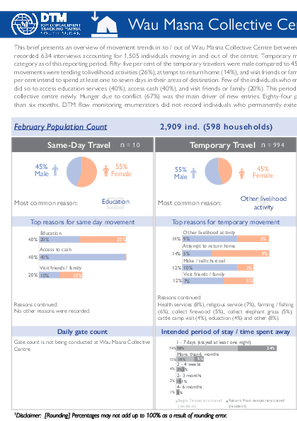
This brief presents an overview of movement trends in to / out of Wau Masna Collective Centre between January and March 2023. The collective centre recorded 634 interviews accounting for 1,505 individuals moving in and out of the centre.
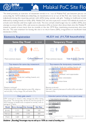
This brief presents an overview of movement trends in to / out of Malakal PoC site between January and March 2023. The site recorded 459 interviews accounting for 1,072 individuals embarking on movements in to or out of the PoC site.
In 2023, DTM Somalia implemented the Galmudug District Profiling houssehold assessment. The aim of the assessment is to strengthen the evidence base on the conditions, needs and vulnerabilities of households in accessible areas of Galmudug state. A total of 1,560 surveys were conducted.
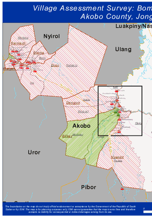
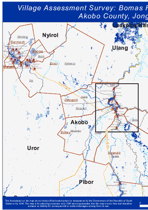
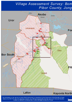
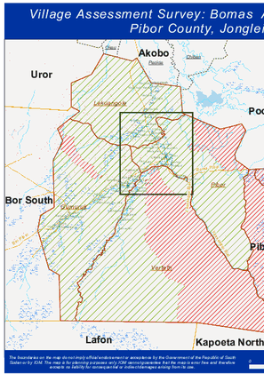
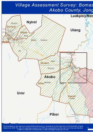
IOM’s Displacement Tracking Matrix (DTM) conducted the Village Assessment Survey (VAS) to facilitate planning for transition and recovery programs.
South Sudan - Baseline Locations Round 11
Dec 01 2021
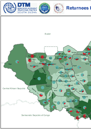
Mobility Tracking quantifies the presence of internally displaced persons (IDPs) and returnees in South Sudan in displacement sites and host communities. As of September 2021, IOM DTM mapped a total of 2,017,236 IDPs (7% previously displaced abroad) and 1,782,803 returnees (34% per cent from abroad…
South Sudan — Flow Monitoring Registry — July 2021
Nov 18 2021
Flow monitoring aims to derive quantitative estimates of the flow of individuals through specific locations and to collect information about the profile, intentions and needs of the people moving and to quantify highly mobile populations by providing a picture of complex mobility dynamics.
South Sudan — Flow Monitoring Registry — June 2021
Sep 30 2021
Flow monitoring aims to derive quantitative estimates of the flow of individuals through specific locations and to collect information about the profile, intentions and needs of the people moving and to quantify highly mobile populations by providing a picture of complex mobility dynamics.
Ethiopia — Village Assessment Survey 9
Sep 24 2021
A village assessment survey (VAS) is a sub-component of mobility tracking. It collects data on returning IDPs, IDPs, returned migrants and host community members. VAS evaluates the absorption capacity of villages to receive returning IDPs with a focus on accessibility of services, livelihoods and…
Ethiopia - Site Assessment Round 26
Sep 24 2021
A site assessment is a sub-component of mobility tracking. It aims to collect data on population presence, living conditions and needs in a particular displacement site or community.
Burundi — Baseline Assessment — Round 65
Sep 17 2021
A baseline assessment is a sub-component of mobility tracking. It aims to collect data on IDP, migrant or returnee population presence in a defined administrative area of the country.
Burundi — Baseline Assessment — Round 64
Sep 15 2021
A baseline assessment is a sub-component of mobility tracking. It aims to collect data on IDP, migrant or returnee population presence in a defined administrative area of the country.
South Sudan - Village / Neighborhood Assessment - Round 10
Sep 14 2021
A baseline assessment is a sub-component of mobility tracking. It aims to collect data on IDP, migrant or returnee population presence in a defined administrative area of the country.
South Sudan — Site Assessment - Round 10
Sep 14 2021
A site assessment is a sub-component of mobility tracking. It aims to collect data on population presence, living conditions and needs in a particular displacement site or community.
Ethiopia - Emergency Site Assessment - Northern Ethiopia Crisis - Round 7
Aug 13 2021
The Emergency Site Assessment is a sub-component of mobility tracking. It aims to collect data on population presence, living conditions and needs in a particular displacement site or community.
Burundi — Baseline Assessment — Round 63
Aug 10 2021
A baseline assessment is a sub-component of mobility tracking. It aims to collect data on IDP, migrant or returnee population presence in a defined administrative area of the country.
Burundi — Baseline Assessment — Round 62
Jul 23 2021
A baseline assessment is a sub-component of mobility tracking. It aims to collect data on IDP, migrant or returnee population presence in a defined administrative area of the country.
South Sudan — Flow Monitoring Registry — May 2021
Jul 23 2021
Flow monitoring aims to derive quantitative estimates of the flow of individuals through specific locations, to collect information about the profile, intentions and mobility history of the people moving, and to quantify highly mobile populations by providing a picture of complex mobility dynamics.
South Sudan - Event Tracking (January - June 2021)
Jul 22 2021
<p>IOM DTM employs Event Tracking as a more rapid and localized assessment tool complementing overall efforts to report on IDP and returnee figures nationally. IOM teams access IDP/returnee locations and consult local key informants including community representatives, local authorities or…
South Sudan - Baseline Assessment Round 10 - IDP and Returnee
Jul 19 2021
A baseline assessment is a sub-component of mobility tracking. It aims to collect data on IDP, migrant or returnee population presence in a defined administrative area of the country. The dataset contains summary by period of arrival (IDP and returnees), reasons for displacement of IDPs by year of…
South Sudan - Baseline Locations Round 10
Jul 19 2021
A baseline assessment is a sub-component of mobility tracking. It aims to collect data on IDP, migrant or returnee population presence in a defined administrative area of the country. In Round 10, DTM covered 3,038 locations.
South Sudan — Flow Monitoring Registry — March 2021
Jul 19 2021
Flow monitoring aims to derive quantitative estimates of the flow of individuals through specific locations, to collect information about the profile, intentions and mobility history of the people moving, and to quantify highly mobile populations by providing a picture of complex mobility dynamics.
Burundi — Baseline Assessment — Round 61
Jul 16 2021
A baseline assessment is a sub-component of mobility tracking. It aims to collect data on IDP, migrant or returnee population presence in a defined administrative area of the country.
Ethiopia — Village Assessment Survey 8
Jul 02 2021
A village assessment survey (VAS) is a sub-component of mobility tracking. It collects data on returning IDPs, IDPs, returned migrants and host community members. VAS evaluates the absorption capacity of villages to receive returning IDPs with a focus on accessibility of services, livelihoods and…
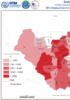
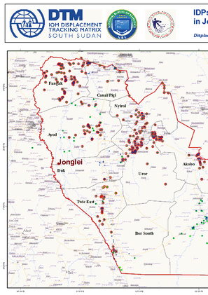
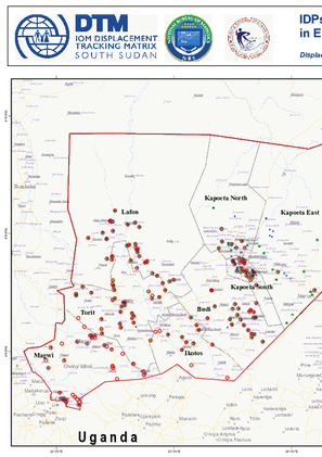
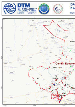
This map displays the numbers of IDPs who have been displaced by conflict at the county level (Mobility Tracking Round 11, September 2021).
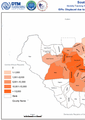
This map displays the numbers of IDPs who have been displaced by communal clashes at the county level (Mobility Tracking Round 11, September 2021).
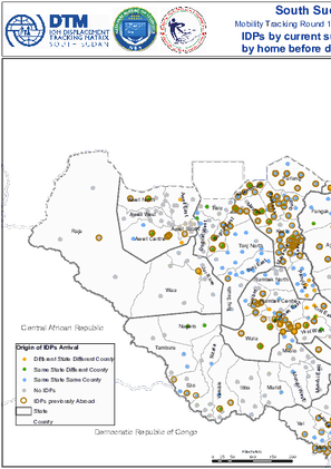
This map shows the payams IDPs are currently in. Where IDPs' origin states and counties are different to those of their currently mapped location, this is indicated (Mobility Tracking Round 11, September 2021).
This map shows the direction of change in the number of IDPs as mapped by round eleven of Mobility Tracking, at the location level (Mobility Tracking Round 11, September 2021).

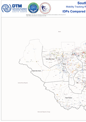
This map compared the locations of IDPs that were mapped during round eleven of Mobility Tracking, as compared to the locations that were mapped in the previous Mobility Tracking Round 10 (Mobility Tracking Round 11, September 2021).
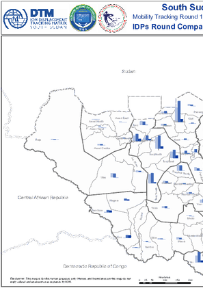
This map compares the number of IDPs as assessed in different rounds of Mobility Tracking, at the county level (Mobility Tracking Round 11, September 2021).
This map displays the subset of IDPs who arrived at their counties in South Sudan from abroad, by period of arrival (Mobility Tracking Round 11, September 2021).


DTM Global Survey 2023
The Displacement Tracking Matrix (DTM) Global Survey 2023 is an annual stocktaking exercise which aims to present IOM DTM's operations and activities transparently. The Global Survey focuses on operations active from January 1 to December 31, 2023, with data collection occurring from February to April 2024.