


Nov 30 2021
- Survey
- Flow Monitoring
Afin de mieux comprendre les mouvements et tendances migratoires, l’OIM, à travers la Matrice de suivi des déplacements (Displacement Tracking Matrix, DTM), met en œuvre l’activité de Suivi des flux de populations (Flow Monitoring, FM).
Le suivi des flux, qui est mis en œuvre en étroite collaboration avec les autorités et des partenaires nationaux et locaux, est composé de deux outils: l’enregistrement des flux (Flow Monitoring Registry, FMR), qui recueille des données clés sur l’ampleur, la provenance, la destination et les modalités des flux de mobilité, et les enquêtes individuelles (Flow Monitoring Survey, FMS), conduites auprès des voyageurs afin d’obtenir des informations sur les profils, parcours migratoires, et intentions des migrants. Le suivi des flux de populations récolte ainsi des données sur les flux et tendances migratoires, les profils des voyageurs et les parcours et intentions des migrants, afin de fournir une meilleure compréhension des mobilités.
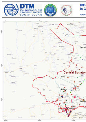
Au Mali, la DTM recueille des données au niveau de 7 Points de suivi des flux (Flow Monitoring Points, FMP), répartis dans 6 régions afin d’obtenir une meilleure compréhension de l’ampleur, des tendances, des caractéristiques socio-démographiques et des parcours des flux de voyageurs traversant ces différents points.
Ce rapport présente les données recueillies dans le cadre des activités d’enregistrement des flux durant le mois de Novembre 2021.

DTM API
Making global IDPs data accessible and reliable
The Displacement Tracking Matrix application programming interface (API) accelerates secure sharing of IDPs’ data, simplifying access to data across users and partners to support action, insight and foresight.