
May 23 2022
- Survey
Since 24 February 2022, refugees and third-country nationals (TCNs) continue to enter Romania as a result of the war in Ukraine. As of 23 May 2022, Romanian authorities have reported 1,010,955 arrivals from Ukraine (data via UNHCR and including in the context of those entering from Ukraine via the Republic of Moldova). This report is based on 4,014 interviews conducted by IOM Romania between 25 March and 23 May 2022 in Brașov, Bucharest, Constanța, Galați, Huși, Iași, Isaccea, Sighetu Marmației, Siret and Suceava.
Jun 01 2022
- Mobility Tracking
- Event Tracking
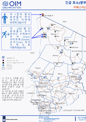
이 긴급 호소는 최근 발생한 갑작스러운 대규모 인구 이동에 대한 정보를 수집하는 것을 목표로 합니다. 주요 정보제공자와의 인터뷰 및 직접적인 관찰을 통해 필요한 정보가 수집되었습니다. 이 대시보드는 5월 말 티베스티(Tibesti) 주 내 발생한 대규모 이동에 대한 내용을 제공합니다. 2022년 5월 23일과 24일 간 쿠리 부구디(Kouri Bougoudi) 지역 내 금광업자들 간 폭력 사태로 인해 100여 명이 사망했습니다. 이 지역은 차드 내 주요 금광 채굴장이 다수 위치해 있는 곳이며, 공식적으로 발표된 바는 없으나 여러 매체는 해당 지역 내 약 4만여 명의 현지 및 외국인 광부들이 분포해 있는 것으로 추정하고 있습니다. 동 소요 사태 이후, 지방 당국은 폭력 사태에 연루된 사람들의 퇴거를 명령하였으며 해당 지역의 모든 금광 채굴을 중단했다고 밝혔습니다. 한 소식통에 따르면 이미 2,000명에 이르는 광부들은 쿠리 부구디 지역에서 벗어나 인근 마을인 주아(Zouar), 주아르케(Zouarké), 우아(Wour) 등으로 피신하였으며, 지방 당국은 이 수가 계속 증가할 수 있다며 우려를 표했습니다. 자원 부족으로 인해 해당 인구는 인근 지역에 계속 체류할 수 밖에 없는 상황이나, 체류 지역 내 기본적 서비스 등도 마련되어 있지 않는 등 매우 취약한 환경에 놓여져 있는 상태입니다. 이들은 또한 밀수 및 인신매매 등과 같은 여러 위험에 노출되어 있습니다. 현재 이들에게 가장 필요한 건 식수, 식량, 생활용품, 그리고 고향으로 돌아갈 수 있는 교통수단입니다. 이런 상황에 맞서기 위해 500만 불의 긴급 지원이 필요합니다.

Jun 05 2022
- Mobility Tracking
- Event Tracking
The DTM Emergency Tracking Tool (ETT) is deployed to track and to collect information on large and13 sudden population movements, provide frequent updates on the scale of displacement and quantify the affected population when needed. As a sub-component of the Mobility Tracking methodology in Nigeria, ETT utilises direct observation and a broad network of key informants to capture best estimates of the affected population per location, enabling targeted humanitarian response planning.
Between 30 May and 05 June 2022, a total of 2,210 movements were recorded in Adamawa and Borno States. The recorded movements consisted of 1,859 arrivals and 351 departures. Arrivals were recorded at locations in Askira/Uba, Bama, Damboa, Gwoza, Kala Balge, Monguno and Ngala Local Government Areas (LGAs) of the most conflict-affected state of Borno and in Fufore, Gombi, Hong, Michika, Mubi South, Song, Yola North and Yola South LGAs of Adamawa State.
Departures were recorded in Askira/Uba LGA of Borno State and in Fufore, Gombi, Hong, Lamurde, Maiha, Michika, Mubi North, Numan, Song and Yola North LGAs of Adamawa State.
ETT assessments identified the following movement triggers: poor living conditions (660 individuals or 30%), military operations (622 individuals or 28%), seasonal farming (598 individuals or 27%), family re-unification (186 individuals or 8%), improved security (134 individuals or 6%) and access to humanitarian support (10 individuals or 1%).

Jun 09 2022
- Mobility Tracking
- Event Tracking
Fear of attacks and subsequent confirmed attacks in Ancuabe district by Non-State Armed Groups triggered displacements movements between 02-09 June. Recent attacks in Nanduli locality triggered the movements of 5,652 individuals within Ancuabe, Chiure, Quissanga, Balama, Mecufi, Mueda, Macomia, Montepuez, Meluco, Namuno, Nampula, Balama, Metuge and Cidade de Pemba. Approximately 246 IDPs have been identified with vulnerabilities. At least 32% of these movements are departures from sites in Metuge. New arrivals recorded within this report map 1,642 individuals predominantly moving into sites across Chiure, Metuge and Ancuabe.

Dec 22 2021
- Other
- Survey
Cette étude a cherché à comprendre plus précisément la nature des flux migratoires liés à l’extraction aurifère dans la région d’Agadez tout en prenant en compte les défis de protection posés pour les migrants, en particulier concernant leur accès aux soins de santé et leurs vulnérabilités face aux risques d’exploitation économique sur les sites d’or. La collecte de données s’est déroulée du 8 au 22 décembre 2021,

Jun 06 2022
- Flow Monitoring
- Migrants presence
Since the onset of the war in Ukraine, a number of people fleeing from Ukraine to neighbouring countries has been observed. This report presents findings based on cumulative and daily registrations, by the General Inspectorate for Border Police (GIBP), since 24 February 2022 onwards, of movement flows of Ukrainian refugees and third-country nationals (TCNs) entering from Ukraine to the Republic of Moldova from all Border Crossing Points (BCPs) and exiting the country from all BCPs, towards Romania and towards Ukraine, as well as via flights. In addition, it presents data on those who entered since 24 February and are still present in the country.

May 27 2022
- Survey
- Return Intention
Since 24 February 2022, an increasing number of people fleeing from Ukraine to the neighbouring countries has been observed, as a result of the war in Ukraine. As of 7 June, 489,283 Ukrainian refugees and third country nationals (TCNs) were registered at border crossing points (BCPs) while entering from Ukraine into the Republic of Moldova. Additionally, 87,621 Ukrainian refugees and TCNs, who have entered into the Republic of Moldova after 24 February, have since exited back to Ukraine.
This report presents a summary of displacement survey findings commissioned by the International Organization for Migration (IOM) in partnership with UN Women. Data were collected before crossing to Ukraine at three main border crossing points (BCPs) – Palanca and Tudora (Stefan Voda district in the South) and Otaci (Ocnita district in the North) between 16 April and 27 May. Individual crossings into Ukraine are not necessarily returnees and conclusions on definitive trends cannot yet be drawn. The sample is not representative of all persons crossing to Ukraine, and results should only be considered as indicative.

Jun 08 2022
- Mobility Tracking
- Event Tracking
Fear of attacks and subsequent confirmed attacks in Ancuabe district by Non-State Armed Groups triggered displacements movements between 02-08 June. Recent attacks in Nduli locality triggered the movements of 4,887 individuals within Ancuabe, Chuire, Quissanga, Balama, Mecufi, Mueda, Macomia, Montepuez, Meluco, Namuno, Nampula, Balama, Metuge and Cidade de Pemba. Approximately 213 IDPs have been identified with vulnerabilities. At least 27% of totl movements observed are departures from sites in Metuge. New arrivals recorded within this report map 996 individuals predominantly moving into sites across Chiure, Metuge and Ancuabe.
Apr 30 2022
- Flow Monitoring
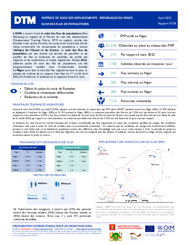
L’OIM, à travers l’outil de suivi des flux de populations (Flow Monitoring en anglais) de la Matrice de suivi des déplacements (Displacement Tracking Matrix, DTM en anglais), récolte des données à des points d’entrée, de sortie et de transit clés afin de mieux comprendre les mouvements de populations à travers l’Afrique de l’Ouest et du Centre. Le suivi des flux de population est une activité qui permet de quantifier et de qualifier les flux et tendances de mobilités, les profils des migrants, et les expériences et routes migratoires. Depuis 2016, plusieurs points de suivi des flux de populations ont été progressivement installés dans d'importantes localités du Niger pour faire le suivi des flux migratoires dans le pays. La période de collecte de ce rapport s’est faite du 1er au 30 Avril 2022 afin d’observer la tendance de la migration durant le mois.
Apr 30 2022
- Flow Monitoring
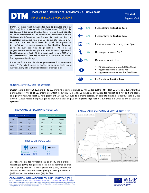
L’OIM, a travers l’outil de Suivi des flux de populations (Flow Monitoring) de la Matrice de suivi des déplacements (DTM), récolte des données à des points d’entrée, de sortie et de transit clés, afin de mieux comprendre les mouvements de populations à travers l’Afrique de l’Ouest et du Centre. Le suivi des flux de population est une activité qui permet de quantifier et de qualifier les flux et tendances de mobilités, les profils des migrants, et les expériences et routes migratoires. Au Burkina Faso, des points de suivi des flux de populations (FMP) ont été progressivement installés sur plusieurs lieux de transit importants à Dori/Seytenga en février 2018, à Kantchari en mars 2018, ainsi qu'à Faramana et Yendéré en avril 2018 pour faire le suivi des flux migratoires dans le pays.
Au Burkina Faso, le suivi des flux de population se fait au niveau des quatre FMP et vise à mettre en lumière les zones particulièrement sujettes aux migrations transfrontalières et intrarégionales.
Ce rapport présente les données recueillies aux FMP du Burkina Faso en avril 2022.

DTM Global Survey 2023
The Displacement Tracking Matrix (DTM) Global Survey 2023 is an annual stocktaking exercise which aims to present IOM DTM's operations and activities transparently. The Global Survey focuses on operations active from January 1 to December 31, 2023, with data collection occurring from February to April 2024.