- Mobility Tracking
- Event Tracking
Nov 06 2022
Population Groups
Survey Methodology
Unit of Analysis Or Observation
Type of Survey or Assessment
Keywords
Geographical Scope
Administrative boundaries with available data
The current dataset covers the following administrative boundaries
- Mobility Tracking
- Event Tracking
Oct 30 2022
Population Groups
Survey Methodology
Unit of Analysis Or Observation
Type of Survey or Assessment
Keywords
Geographical Scope
Administrative boundaries with available data
The current dataset covers the following administrative boundaries

Aug 31 2022
- Mobility Tracking
- Baseline Assessment
Depuis 2014, le Cameroun est l’objet d’attaques perpétrées par des groupes armés. Les attaques et les menaces récurrentes continuent de provoquer des déplacements de populations vivant dans la région de l’Extrême-Nord. Du fait de sa situation géographique et culturelle, et notamment sa proximité avec le Nigéria et le Tchad, la région a subi des dégâts matériels et humains importants.
En réponse, l’Organisation Internationale pour les Migrations (OIM) déploie, depuis novembre 2015, la Matrice de suivi des déplacements (Displacement Tracking Matrix- DTM, en anglais), un outil qui collecte des données sur les tendances de déplacement ainsi que les besoins humanitaires multisectoriels des personnes affectées par les crises. A travers sa composante du suivi des déplacements, la DTM collecte des données auprès d’informateurs clés (autorités locales, chefs de communautés, représentants de déplacés, gestionnaires de sites) au sein des localités et sites d’accueil des déplacés, retournés et réfugiés hors camp. Ces informations sont analysées et partagées avec la communauté humanitaire afin d’orienter les programmes de réponse ou des évaluations sectorielles plus approfondies.
Ce tableau de bord présente la situation de déplacement dans 1191 localités (1092) et site spontanés (99) accueillant les personnes déplacées internes (PDI), retournés et réfugiés hors camp. La collecte de données a été réalisée auprès de 4 298 informateurs clés entre le 11 et 24 août 2022 dans 6 départements de la région de l’Extrême-Nord : Diamaré, Logone-Et-Chari, Mayo-Danay, Mayo-Kani, Mayo Sava et Mayo-Tsanaga.
Nov 05 2022
- Rapid Emergency Registration
- Mobility Tracking
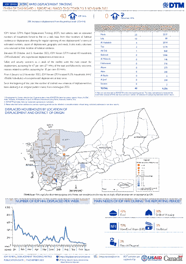
IOM Yemen DTM’s Rapid Displacement Tracking (RDT) tool collects data on estimated numbers of households forced to flee on a daily basis from their locations of origin or displacement, allowing for regular reporting of new displacements in terms of estimated numbers, geography, and needs. It also tracks returnees who returned to their location of origin.
From 1 January to 5 November 2022, IOM Yemen DTM tracked 9,276 households (HH) (55,656 Individuals) who experienced displacement at least once.
Between 30 October and 5 November 2022, IOM Yemen DTM tracked 40 households (240 individuals) displaced at least once. The majority of people moved into/within the following governorates and districts:
- Marib (23 HHs) – Marib City (16 HHs), Marib (7 HHs) districts. Most displacements in the governorate originated from Shabwah and Marib.
- Lahj (10 HHs) – Al Musaymir (10 HHs) district. All displacements in the governorate were internal.
- Al Hodeidah (4 HHs) – Hays (4 HHs) district. Most displacements in the governorate originated from Al Hodeidah and Taiz.
The majority of people moved from the following governorates and districts:
- Lahj (11 HHs) – Al Musaymir (11 HHs) district.
- Al Hodeidah (5 HHs) – Hays (3 HHs), Al Marawiah (2 HHs) districts.
Shabwah (4 HHs) – Ataq (3 HHs), Bayhan (1 HH) districts.
- Mobility Tracking
- Event Tracking
Nov 05 2022
- Marib (23 HHs) – Marib City (16 HHs), Marib (7 HHs) districts. Most displacements in the governorate originated from Shabwah and Marib.
- Lahj (10 HHs) – Al Musaymir (10 HHs) district. All displacements in the governorate were internal.
- Al Hodeidah (4 HHs) – Hays (4 HHs) district. Most displacements in the governorate originated from Al Hodeidah and Taiz.
- Lahj (11 HHs) – Al Musaymir (11 HHs) district.
- Al Hodeidah (5 HHs) – Hays (3 HHs), Al Marawiah (2 HHs) districts.
- Shabwah (4 HHs) – Ataq (3 HHs), Bayhan (1 HH) districts.
Population Groups
Survey Methodology
Unit of Analysis Or Observation
Type of Survey or Assessment
Keywords
Geographical Scope
Administrative boundaries with available data
The current dataset covers the following administrative boundaries
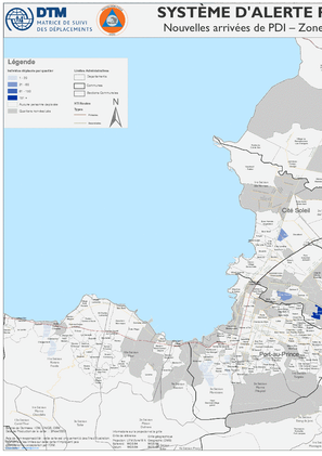
Nouvelles arrivées dans la Zone Métropolitaine de Port-au-Prince (15 – 21 Octobre 2022)
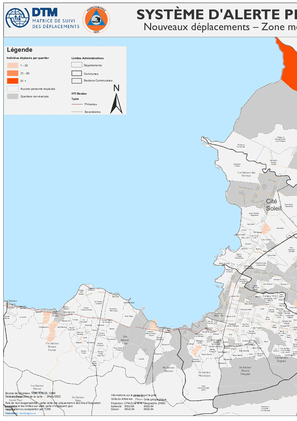
Nouveaux déplacements dans la Zone Métropolitaine de Port-au-Prince (15 – 21 Octobre 2022)
Nouvelles arrivées dans la Zone Métropolitaine de Port-au-Prince (8 – 14 Octobre 2022)
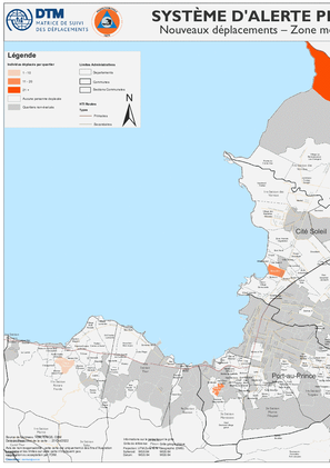
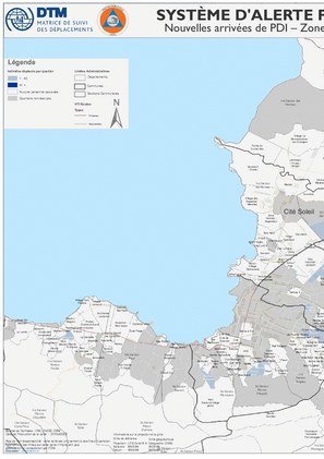
Nouveaux déplacements dans la Zone Métropolitaine de Port-au-Prince (8 – 14 Octobre 2022)
Sep 30 2022
- Flow Monitoring
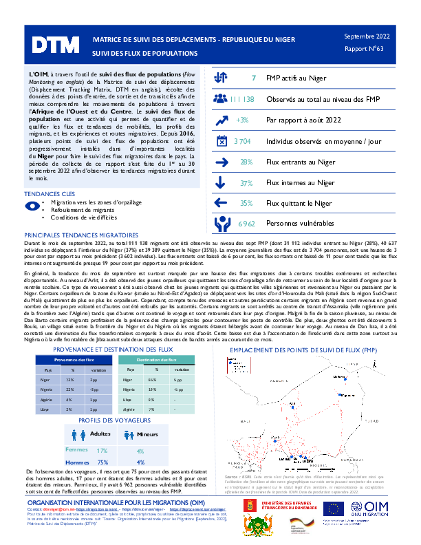
L’OIM, à travers l’outil de suivi des flux de populations (Flow Monitoring en anglais) de la Matrice de suivi des déplacements (Displacement Tracking Matrix, DTM en anglais), récolte des données à des points d’entrée, de sortie et de transit clés afin de mieux comprendre les mouvements de populations à travers l’Afrique de l’Ouest et du Centre. Le suivi des flux de population est une activité qui permet de quantifier et de qualifier les flux et tendances de mobilités, les profils des migrants, et les expériences et routes migratoires. Depuis 2016, plusieurs points de suivi des flux de populations ont été progressivement installés dans d'importantes localités du Niger pour faire le suivi des flux migratoires dans le pays. La période de collecte de ce rapport s’est faite du 1er au 30 septembre 2022 afin d’observer les tendances migratoires durant le mois.

DTM API
Making global IDPs data accessible and reliable
The Displacement Tracking Matrix application programming interface (API) accelerates secure sharing of IDPs’ data, simplifying access to data across users and partners to support action, insight and foresight.