Event Tracking


Oct 20 2024
- Mobility Tracking
- Event Tracking
Between 14 and 20 October 2024, 56 new arrivals were recorded at locations in Benue State, including the Gwer West and Logo local government areas (LGAs).

Oct 13 2024
- Mobility Tracking
- Event Tracking
Between 7 and 13 October 2024, 832 new arrivals were recorded at locations in Benue State, including the Guma, Gwer West and Logo local government areas (LGAs).

Sep 30 2024
- Mobility Tracking
- Event Tracking
In South Sudan, a multifaceted humanitarian crisis is currently unfolding, driven by a combination of factors including communal conflicts, land disputes, widespread insecurity, violence, natural disasters, and cross-border displacement. These elements have created a challenging environment for the population, exacerbating the already dire humanitarian situation. The ongoing instability has led to significant disruptions in livelihoods and access to basic services, leaving many communities vulnerable and in urgent need of assistance.
In the month of September 2024, Juba, Fangak, Fashoda, and Wau Counties witnessed the arrival of 7,481 returnees. All these individuals returned as a result of the ongoing crisis in Sudan. This movement highlights the impact of the ongoing Sudan conflict, forcing thousands to flee and seek safety. While returnees are hopeful about reintegrating into their communities, they might face significant challenges in rebuilding their lives.

Sep 30 2024
- Mobility Tracking
- Event Tracking
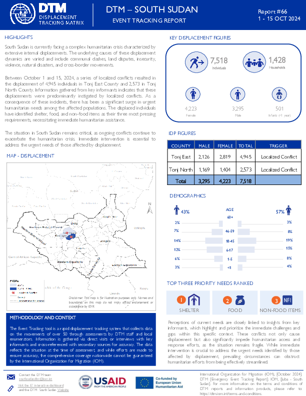
South Sudan is currently facing a complex humanitarian crisis characterized by extensive internal displacements. The underlying causes of these displacement dynamics are varied and include communal clashes, flooding, insecurity, violence, natural disasters, and cross-border movements.
In the month of September 2024, enumerators from the Displacement Tracking Matrix documented significant flood-induced displacements affecting 44,497 individuals. The majority of these displacements occurred in Northern Bahr el Ghazal where 14,455 individuals were displaced to Aweil East, 11,756 to Aweil West and 9,030 to Aweil North. Additionally, 11,930 individuals were displaced to Abyei Administrative Area, while Jonglei and Western Bahr el Ghazal saw 6,500 and 995 individuals displaced to Fangak and Jur River, respectively.
The effect of these displacements calls for urgent humanitarian intervention among the affected population. Those who have been displaced identified their most pressing requirements as being in dire need of food, health and shelter.
Oct 15 2024
- Mobility Tracking
- Event Tracking
South Sudan is currently facing a complex humanitarian crisis characterized by extensive internal displacements. The underlying causes of these displacement dynamics are varied and include communal clashes, land disputes, insecurity, violence, natural disasters, and cross-border movements.
Between October 1 and 15, 2024, a series of localized conflicts resulted in the displacement of 4,945 individuals in Tonj East County and 2,573 in Tonj North County. Information gathered from key informants indicates that these displacements were predominantly instigated by localized conflicts. As a consequence of these incidents, there has been a significant surge in urgent humanitarian needs among the affected populations. The displaced individuals have identified shelter, food, and non-food items as their three most pressing requirements, necessitating immediate humanitarian assistance.
The situation in South Sudan remains critical, as ongoing conflicts continue to exacerbate the humanitarian crisis. Immediate intervention is essential to address the urgent needs of those affected by displacement.

Oct 15 2024
- Mobility Tracking
- Event Tracking
South Sudan is currently facing a complex humanitarian crisis characterized by extensive internal displacements. The underlying causes of these displacement dynamics are varied and include communal clashes, flooding, insecurity, violence, natural disasters, and cross-border movements.
Between 1st and 15th October 2024, enumerators from the Displacement Tracking Matrix documented significant disaster (flood) related displacements affecting 10,719 individuals. The majority of these displacements occurred in Northern Bahr el Ghazal where 7,775 individuals were displaced to Aweil West, 1,954 to Mayom County in Unity State, and 990 to Abyei Administrative Area.
The effect of these displacements calls for urgent humanitarian intervention among the affected population. Those who have been displaced identified their most pressing requirements as being in dire need of food, shelter, and non-food items.

Oct 23 2024
- Mobility Tracking
- Event Tracking
This report is an update of the one published on 20 October (ETT 51) following the armed attacks that have occurred since 17 October 2024 in the bordering areas of the municipalities of Port-au-Prince and Delmas on the one hand, particularly in the neighborhoods of Solino and Cité Numéro 2 and on the other hand in the municipality of Tabarre, precisely in the neighborhood of Tabarre 27. A total of 10,056 people were displaced following these attacks, including 8,361 due to the attacks in Port-au-Prince and Delmas and 1,695 due to those in Tabarre. The majority of people (55%), or 5,557 people, took refuge in 14 sites, including 10 that already existed before these incidents and 4 newly created following these incidents. The rest of the people (45%) took refuge with host families.

Oct 13 2024
- Mobility Tracking
- Event Tracking
On 08 and 09 October 2024, flood occurred in the communities of Sa’achi and Egaji in Mambe ward of Lavun local government area (LGA) and Gbami in Ebbo/Gbachukunku ward of Lapai LGA, all in Niger State. Ten injuries were reported. The flood affected 1,000 individuals in 231 households, including 704 children, 163 women and 133 men, and destroyed 98 shelters and personal belongings.
On 10 October 2024, a farmer-herders clash occurred in the community of Nagi in Mbachohon ward of Gwer West LGA in Benue State. The clash affected one household comprising of six individuals, including two children, three women and a man. There were reports of three injuries and one fatality.
Additionally, on 10 and 12 October 2024, armed bandits attacked the communities of Kyado in Mbazun ward of Ukum LGA of Benue State and Gidan Sambo in Kungurki ward of Kaura Namoda LGA in Zamfara State. The attacks affected 418 individuals in 84 households, including 228 children, 100 women and 90 men. There were reports of three injuries and two fatalities.
Oct 13 2024
- Mobility Tracking
- Event Tracking
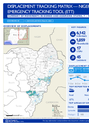
Between 7 and 13 October 2024, a total of 6,142 new arrivals were recorded at locations in Adamawa and Borno states.
ETT assessments identified the following movement triggers: flood (5,404 individuals or 88), poor living conditions (280 individuals or 5%), attacks (103 individuals or 2%), seasonal farming (90 individuals or 1%), improved security (68 individuals or 1%), trade (57 individuals or 1%), family re-unification (56 individuals or 1%), fear of attack (42 individuals or 1%), communal clash (17 individuals or less than 1%) and government re-integration (3 individual or less than 1%).

DTM Global Survey 2023
The Displacement Tracking Matrix (DTM) Global Survey 2023 is an annual stocktaking exercise which aims to present IOM DTM's operations and activities transparently. The Global Survey focuses on operations active from January 1 to December 31, 2023, with data collection occurring from February to April 2024.