
Apr 30 2024
- Flow Monitoring
- Flow Monitoring Registry
IOM Somalia DTM’s flow monitoring team tracks migrant movements at seven active Flow Monitoring Points (FMPs) along the border with Ethiopia, Kenya, and Djibouti and at Bossa FMP on the coast. Enumerators stationed at FMPs register migrant entries and exits to detect different migration patterns, and to provide numerical estimates to help estimate the population of irregular migrants who enter and exit the country. Flow monitoring does not capture all flows into and out of Somalia and should be seen as only indicative of migration trends of the unknown total number of migrants who move in and out of Somalia at FMPs during the indicated time frame.
A total of 22,611 movements were observed in April 2024, representing a 16% decrease compared to March 2024 when 26,793 movements were observed during this period. Comparing April 2024 with March 2024, Doolow (-25%), Lowyacado (-8%), Harirad (-6%), Dhobley (-4%) , Bossaso(-3%) and Cabudwaaq (-2%) FMPs recorded a decrease in movements while Buuhoodle (5%) FMP recorded an increase in movements.
Doolow (57%), Bossaso (28%), and Dhobley (7%) FMPs recorded the highest numbers of incoming movements, while Doolow (31%), Dhobley (27%) and Cabudwaaq (18%) recorded the highest numbers of outgoing movements for April 2024.

Mar 31 2024
- Flow Monitoring
- Flow Monitoring Registry
A total of 26,793 movements were observed in March 2024, representing a 35% increase compared to February 2024 when 19,813 movements were observed during this period. Compiring March 2024 with February 2024, Doolow (+69%), Bossaso (+16%), Buuhoodle (+12%), Cabudwaaq (+10%) , Lowyacado (+4%) and Dhobley (+4%) FMPs recorded an increase in movements while Harirad (-19%) FMP recorded a decrease in movements.
Doolow (29%), Dhobley (27%), and Cabudwaaq (19%) FMPs recorded the highest numbers of incoming movements, while Doolow (64%), Bossaso (23%) and Dhobley (6%) recorded the highest numbers of outgoing movements for March 2024.

Feb 29 2024
- Flow Monitoring
- Flow Monitoring Registry
A total of 19,813 movements were observed in February 2024, representing a 6% decrease compared to January 2024 when 21,115 movements were observed during this period.
If compared with January 2024, Cabudwaaq (-19%), Bossaso (-14%), Buuhoodle (-12%), Hirarad (-4%) and Doolow (-3%) FMPs recorded a decrease in movements while Dhobley (+3%) and Lowyacado (+<1%) FMP recorded an increase in movements.
Dhobley (30%), Doolow (25%) and Cabudwaaq (19%) FMPs recorded the highest numbers of incoming movements, while Doolow (52%), Bossaso (29%) and Dhobley (8%) recorded the highest numbers of outgoing movements.

Jan 31 2024
- Flow Monitoring
- Flow Monitoring Registry
A total of 21,115 movements were observed in January 2024, representing a 10% increase compared to December 2023 when 19,192 movements were observed during this period.
If compared with December 2023, Lowyacado (28%), Dhobley (25%), Doolow (15%), Harirad (10%) and Cabudwaaq (10%) FMPs recorded an increase in movements while Buuhoodle (-15%) and Bossaso (-0.3%) FMP recorded a decrease in movements.
Doolow (37%), Dhobley (20%) and Cabudwaaq (20%) FMPs recorded the highest numbers of incoming flows, while Doolow (46%), Bossaso (32%) and Dhobley (10%) recorded the highest numbers of outgoing flows.
Mar 31 2024
- Mobility Tracking
Climate-Induced Displacement report (Arabic translation) provides quarterly updates on the number and locations of vulnerable families forced to be displaced due to climatic and environmental factors.
Dec 31 2023
- Survey
- Return Intention
- Mobility Tracking
- Baseline Assessment
he Return Index report (Arabic translation) provides triannual updates on the severity of conditions in locations of return using 16 indicators across two domains: (1) livelihoods and basic services, and (2) social cohesion and safety perceptions.

Dec 31 2023
- Mobility Tracking
- Baseline Assessment
The Master List report (Arabic translation) provides triannual updates on the number of IDPs and returnees in Iraq, recent movements and overall trends, shelter type, IDP areas of origin and areas of no return.
May 23 2024
- Mobility Tracking
- Event Tracking
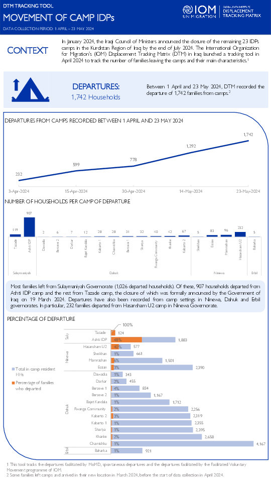
In January 2024, the Iraqi Council of Ministers announced the closure of the remaining 23 IDPs camps in the Kurdistan Region of Iraq by the end of July 2024. The International Organization for Migration’s (IOM) Displacement Tracking Matrix (DTM) in Iraq launched a tracking tool in April 2024 to track the number of families leaving the camps and their main characteristics.

Nov 30 2022
- Survey
This factsheet on Sinjar District is an extension of the original pilot project in Ninewa Governorate aimed at assessing progress towards durable solutions to displacement for internally displaced persons (IDPs) and returnees in the governorates with the largest shares of displaced populations in Iraq. The goal is to understand where IDPs and returnees in Sinjar District stand five years after the end of the 2014–2017 crisis and in which aspects they are still struggling. In this respect, this project contributes to a broader discussion and Action Agenda around measuring progress towards solutions and determining the end of displacement. The assessment measured progress along five criteria stemmed from the Inter-Agency Standing Committee (IASC) Framework for Durable Solutions: 1) safety and security; 2) adequate standards of living; 3) access to livelihoods; 4) restoration of housing, land and property (HLP) and compensation and 5) personal documentation and participation.
Data collection for this factsheet took place in November 2022, across 3 sub-districts and 17 locations in the district of Sinjar. The focus of the study was on both IDPs and returnees within the district, including IDPs who are displaced within the district itself. Data were collected through IOM’s Rapid Assessment and Response Teams (RARTs), composed of over 73 staff members (40% of enumerators are female). They collected data through structured face-to-face interviews with a sample size of 310 IDP and 336 returnee households in Sinjar district.

Jun 30 2024
- Flow Monitoring
The International Organization for Migration (IOM) in Pakistan collects data on the outflows of Afghans at the Torkham (Khyber Pakhtunkhwa), Badini, Bahramcha and Chaman (Balochistan) border crossing points (BCPs) to better understand the movements of Afghans returning to Afghanistan. The data presented below is harmonised with those from the United Nations High Commissioner for Refugees (UNHCR), who also cover Ghulam Khan (Khyber Pakhtunkhwa).
On 26 September 2023, the Ministry of Interior in Pakistan announced its decision to enact its “Illegal Foreigners’ Repatriation Plan (IFRP)”. Between 16 and 30 June 2024, 15,149 Afghan nationals returned to Afghanistan, including 12,434 through the Torkham BCP, 2,580 through the Chaman BCP, 135 through the Ghulam Khan BCP, while no Afghan nationals returned through the Badini and Bahramcha BCPs. In addition, border authorities deported 342 individuals due to a lack of valid documentation. Since 1 January 2024, IOM identified 156,580 returns at the four BCPs.

DTM Global Survey 2023
The Displacement Tracking Matrix (DTM) Global Survey 2023 is an annual stocktaking exercise which aims to present IOM DTM's operations and activities transparently. The Global Survey focuses on operations active from January 1 to December 31, 2023, with data collection occurring from February to April 2024.