Mar 31 2023
- Flow Monitoring
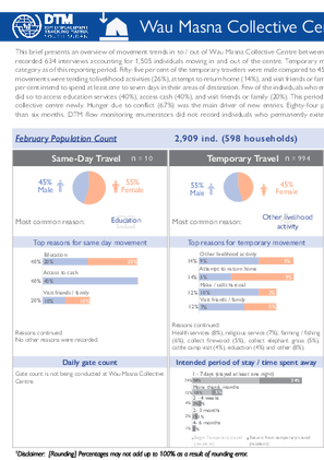
This brief presents an overview of movement trends in to / out of Wau Masna Collective Centre between January and March 2023. The collective centre recorded 634 interviews accounting for 1,505 individuals moving in and out of the centre. Temporary movement (994 individuals) was the main travel category as of this reporting period. Fifty-five per cent of the temporary travelers were male compared to 45 per cent female. The main drivers of temporary movements were tending to livelihood activities (26%), attempt to return home (14%), and visit friends or family (12%). Of those who traveled temporarily, 74 per cent intend to spend at least one to seven days in their areas of destination. Few of the individuals who embarked on same-day movements (6 individuals) did so to access education services (40%), access cash (40%), and visit friends or family (20%). This period also recorded 227 individuals who entered the collective centre newly. Hunger due to conflict (67%) was the main driver of new entries. Eighty-four per cent of new arrivals intend to spend more than six months. DTM flow monitoring enumerators did not record individuals who permanently exited Masna Collective Centre during this period.

Mar 31 2023
- Flow Monitoring
IOM’s Displacement Tracking Matrix (DTM) continued conducting Displacement Site Flow Monitoring (DSFM) at the gates of Naivasha IDP camp. During this period (January to March 2023), 1,409 interviews were conducted representing 4,734 individuals moving in to or out of the camp. Surveyed day movements (4,682 individuals) dominated compared to other travel categories and were predominantly undertaken by female travelers (60%). The main reasons for these movements were to visit friends or family (46%), other livelihood activities (29%), to purchase things from the market (9%), collect firewood (5%) and access to health care services (4%). Fifty-two individuals were recorded permanently exiting Naivasha IDP camp. More than a half of the exits were dominated by male travelers (58%). The main reason that forced people to move out of the camp was improved living conditions at locations of destination. Of those who permanently exited, 58 per cent moved to their former area but new homes, 23 per cent moved to former their former homes, 19 per cent moved to new homes in different areas, all of whom moved to Wau county. DTM enumerators did not capture individuals engaged in temporary movements and new arrivals.
Mar 31 2023
- Flow Monitoring
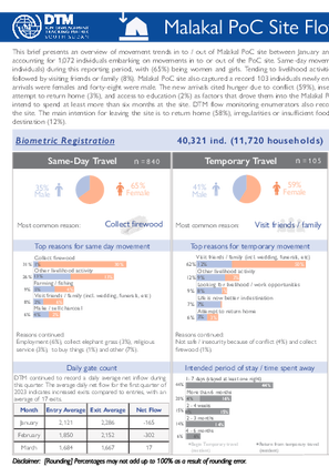
This brief presents an overview of movement trends in to / out of Malakal PoC site between January and March 2023. The site recorded 459 interviews accounting for 1,072 individuals embarking on movements in to or out of the PoC site. Same-day movement was the most recorded travel category (840 individuals) during this reporting period, with (65%) being women and girls. Tending to livelihood activities (72%) has been the key driver of movements followed by visiting friends or family (8%). Malakal PoC site also captured a record 103 individuals newly entering the PoC site. Fifty-two per cent of the new arrivals were females and forty-eight were male. The new arrivals cited hunger due to conflict (59%), insecurity due to conflict (20%), joining family (15%), attempt to return home (3%), and access to education (2%) as factors that drove them into the Malakal PoC site. Of those who arrived newly, 98 per cent intend to spend at least more than six months at the site. DTM flow monitoring enumerators also recorded twenty-four individuals permanently leaving the site. The main intention for leaving the site is to return home (58%), irregularities or insufficient food rations (30%), and improved living conditions at destination (12%).

Mar 31 2023
- Flow Monitoring
This brief presents an overview on movement trends in to / out of Bentiu IDP camp between January and March 2023. The camp recorded 43,878 individuals through 10,379 interviews conducted. Temporary travel was the most common movement category, with an overall 22,745 individuals engaging in such movements. Tending to livelihood activities (48%) was the main cause of these temporary movements followed by visiting friends or family (18%) and checking on or repairing damaged property (9%). Same-day movements (19,768 individuals) were the second most recorded travel category. New arrivals were also recorded in the IDP camp, 30 per cent of whom entered to be with family, destroyed homes due to natural disasters (24%), hunger due to natural disasters (17%), access to health care (9%), and access to services (9%). Of the new arrivals, 47 per cent wish to spend more than six months in the IDP camp. Bentiu IDP camp captured 892 individuals permanently leaving the camp. These exits were motivated by the need to look for education opportunities (42%), joining family (24%), looking for better livelihood or work opportunities (17%), and improved living condition in destination (6%). Forty-two per cent of those who exited moved to former homes Guit, Rubkona, Fangak, Koch, and Juba counties.


- Baseline Assessment
Базова територіальна оцінка зареєстрованих ВПО надає детальні дані щодо кількості та географічного розташування офіційно зареєстрованих внутрішньо переміщених осіб (ВПО). У звіті оцінено присутність зареєстрованих ВПО на рівні громад, а також відображено на мапі зафіксовані зміни, що відбулися з попереднього раунду. У раунді 26 представлені дані щодо кількості зареєстрованих ВПО із розподілом за статтю, віком та визнаним державою статусом особи з інвалідністю1.
Дані, зібрані для раунду 26 базового територіального оцінювання, відображають актуальні цифри місцевого адміністративного реєстру ВПО станом на 31 липня 2023 року, що складає 3 677 601 зареєстрованих ВПО. Дані щодо кількості зареєстрованих ВПО було зібрано для 1 039 громад (78% усіх охоплених громад на підконтрольних українському уряду територіях). Дані з розподілом за віком, статтю та статусом особи з інвалідністю було надано для приблизно 76% охоплених адміністративно-територіальних одиниць.
Для цілей цього оцінювання МОМ визначає ВПО як осіб, які офіційно зареєстровані як такі, що залишили своє звичне місце проживання через нинішню війну в Україні.
- Mobility Tracking
- Baseline Assessment
- Migrants presence
Jun 30 2023
The MPM assessment follows the methodology of IOM’s global Displacement Tracking Matrix (DTM) Mobility Tracking component. Tailored to the operational context in Lebanon, the MPM assessment analyzes data to provide multi-layered information on the presence and mobility of migrants. This assessment aims to complement existing data collection exercises and it is implemented in coordination with key actors to maximize synergies, interoperability and avoid duplication.
Aggregated data is available through the DTM API: https://dtm.iom.int/data-and-analysis/dtm-api
A more detailed version of this dataset is available, to get access kindly click on the 'Request Access' button
Population Groups
Survey Methodology
Unit of Analysis Or Observation
Type of Survey or Assessment
Keywords
Geographical Scope
Administrative boundaries with available data
The current dataset covers the following administrative boundaries

Jun 30 2023
- Migrants presence
- Mobility Tracking
- Baseline Assessment
This report presents the findings of the Migrant Presence Monitoring (MPM) data collection exercise conducted by IOM in Lebanon from April to June 2023, covering all districts. The MPM is an annual assessment that aims to determine the number of migrants present in different areas of Lebanon to support humanitarian assistance and planning efforts. To ensure accurate data, the MPM relies on key informants (KIs), such as representatives from migrant communities, local leaders (mukhtars), and municipal officials. This year, recruitment agencies were also included as KIs to enhance data reliability in their respective areas. The assessment focuses on small areas to gather detailed and precise information. It not only categorizes migrants by nationality, sex, and age but also considers their living situations, distinguishing between “live-in” and “live-out” migrants. Overall, the MPM provides valuable insights into the migrant population in Lebanon, contributing to informed decision-making and effective support for those in need.
The information from IOM-MPM's findings, complementary to data from past assessments, aims to enable partners across the international community and Lebanese partners to have access to an evidence base on migrant presence, to support well-informed, targeted, and coordinated response. The complementary evidence generated from the MPM exercise also serves as a baseline and tertiary source for triangulation for other data collection exercises. For example, MPM data was used to develop of a sampling frame of migrants for the Multi-Sectorial Needs Assessment (MSNA) 2021, 2022 and 2023 exercises led by the Humanitarian Country Team (HCT).
The MPM assessment follows the methodology of IOM’s global Displacement Tracking Matrix (DTM) Mobility Tracking component. Tailored to the operational context in Lebanon, the MPM assessment analyzes data to provide multi-layered information on the presence and mobility of migrants. This assessment aims to complement existing data collection exercises and it is implemented in coordination with key actors to maximize synergies, interoperability and avoid duplication.

Mar 31 2023
- Flow Monitoring Survey
- Migrants presence
- Mobility Tracking
The report aims to present the most up-to-date data on migration dynamics in Uzbekistan, drawing upon data for 2022, 2021, or the latest
available year from national and international datasets on migratory movements and migrant population groups. The report covers the recent
major global and regional developments which will continue to have an impact on internal and international migration in the country, such as the COVID-19 pandemic and its impact on mobility caused by travel restrictions and stricter border controls; the Russian invasion of Ukraine and the resulting humanitarian crisis across the country and the region; the specific bilateral labour agreements issued by Uzbekistan with partner countries; and the climate change as push factor of human mobility, to name a few.

DTM Global Survey 2023
The Displacement Tracking Matrix (DTM) Global Survey 2023 is an annual stocktaking exercise which aims to present IOM DTM's operations and activities transparently. The Global Survey focuses on operations active from January 1 to December 31, 2023, with data collection occurring from February to April 2024.