Thematic Map
Focuses on a particular subject area

This map provides information on Total inflow (Returnees from Abroad + Arrival IDPs) during the period from 2012 through December 2019.

This map provides information on Returnees from Abroad, Afghans who had fled abroad for at least 6 months and have now returned to Afghanistan, during the period from 2012 through December 2019.

This map provides information on Returned IDPs, Afghans from an assessed village who had fled as IDPs in the past and now returned home, during the period from 2012 through December 2019.
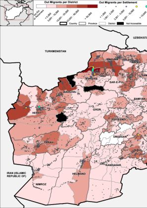
This map provides information on Out Migrants, Afghans who moved or fled abroad, during the period from 2012 through December 2019.

This map provides information on Fled IDPs, Afghans who have fled an assessed settlement as IDPs to reside elsewhere in Afghanistan, during the period from 2012 through December 2019.

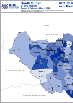
This map displays the number of IDPs by county as of March 2020 (round 8 of mobility tracking).
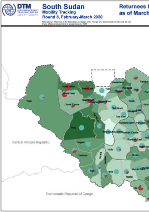
This map displays the number of returnees by county as of March 2020 (round 8 of mobility tracking).
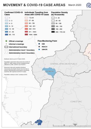
IOM DTM, UNHCR and REACH combined their flow monitoring data for South Sudan with geographically disaggregated data about COVID-19 cases in neighbouring countries compiled by UNICEF, with the aim of mapping population inflows at risk of COVID-19 transmission. The analysis is indicative of incoming movements 73 flow monitoring points at South Sudan’s borders and internal transport hubs, of which 65 recorded incoming cross-border travel in March 2020. This map shows inflows from COVID-19 affected areas in neighbouring countries in March 2020. COVID-19 cases in neighbouring countries are mapped at the first administrative level in Kenya, the Democratic Republic of Congo and the Central African Republic, and at the second administrative level in Uganda, Sudan and Ethiopia.

IOM DTM, UNHCR and REACH combined their flow monitoring data for South Sudan with geographically disaggregated data about COVID-19 cases in neighbouring countries compiled by UNICEF, with the aim of mapping population inflows at risk of COVID-19 transmission. The analysis is indicative of incoming movements 73 flow monitoring points at South Sudan’s borders and internal transport hubs, of which 65 recorded incoming cross-border travel in March 2020. This map shows inflows from affected areas in neighbouring countries in March 2020. Cases are mapped at the first administrative level for Kenya, the Central African Republic and the Democratic Republic of Congo, and at the second administrative level for Ethiopia, Uganda and Sudan.

DTM API
Making global IDPs data accessible and reliable
The Displacement Tracking Matrix application programming interface (API) accelerates secure sharing of IDPs’ data, simplifying access to data across users and partners to support action, insight and foresight.