-
Countries
-
Data and Analysis
-
Special Focus
-
Crisis Responses
Internal displacement
Domain host
displacement.iom.int

Contact
DTM Somalia, IOMSomaliaDTM@iom.int
Language
English
Location
Somalia
Period Covered
May 18 2024
May 22 2024
Activity
- Mobility Tracking
- Baseline Assessment
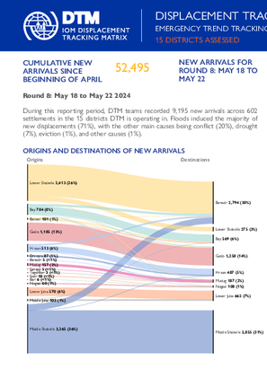
This latest round of Emergency Trends Tracking was initiated in April 2024 to monitor displacements movements during the Gu rainy season. Districts covered in this round include Afgooye, Afmadow, Baardheere, Baidoa, Balcad, Belet Weyne, Gaalkacyo, Garoowe, Jamaame, Jowhar, Kismaayo, and Luuq.
ETT is a crisis-based tool that tracks sudden displacement triggered by specific events or emerging crises. The objective of ETT is to help prioritize humanitarian response and to enable partners to deliver rapid assistance. Based on previous shock induced displacement patterns, the humanitarian community expects that people will continue to move toward urban areas in search of humanitarian services. Consequently, the ETT coverage focuses on the main urban centers and surrounding villages for each assessed district. The data is collected through Key Informant Interviews (KIIs) at the location level, from Sunday to Wednesday every week. It includes information on new arrivals, numbers and demographic of IDPs, reasons for displacement, intentions, humanitarian assistance and priority needs among others.

Contact
DTM Sudan; dtmsudan@iom.int
Language
English
Location
Sudan
Period Covered
Apr 26 2024
May 08 2024
Activity
- Mobility Tracking
- Baseline Assessment
This report reflects data corresponding to Sudan Mobility Update (1) dataset. The dataset is available here.
Overview:
This report provides an overview of the total population of internally displaced persons (IDPs) in Sudan, including those displaced both before and after the onset of conflict on 15 April 2023.
The displacement crisis in Sudan has been unfolding for over two decades, with roots in the Darfur conflict beginning in 2003. Prior to the onset of conflict on 15 April 2023, Sudan already hosted an estimated 3,820,772 IDPs. The majority (80%) reportedly originated from Darfur states, and most were initially displaced between 2003 and 2010. Of these IDPs, many experienced secondary displacement after 15 April 2023. Since 15 April 2023, an estimated 7,111,788 individuals were displaced internally within Sudan — including those who experienced secondary displacement.
When accounting for those displaced both before and after 15 April 2023, DTM estimated that Sudan hosted a total of 9,957,655 IDPs.
Key Findings:
- An estimated total of 9,957,655 IDPs were displaced across 7,869 locations, in 183 localities in all 18 states in Sudan.
- An estimated 7,111,788 individuals were displaced internally within Sudan since 15 April 2023.
- An estimated 26 per cent of IDPs who were initially displaced prior to the onset of current conflict experienced secondary displacement since 15 April 2023.
- Approximately 2,111,791 individuals crossed borders into neighbouring countries since 15 April 2023.
- The top states of origin among IDPs were Khartoum (36%), South Darfur (21%), and North Darfur (12%).
- The states hosting the most IDPs were South Darfur (18%), North Darfur (13%) and Central Darfur (9%).
- Over half (56%) of IDPs were reportedly children under the age of 18-years-old.
Note: The number of IDPs displaced post 15 April 2023 (7,111,788 IDPs) includes the estimated 974,905 IDPs who were initially displaced prior to 15 April 2023 and experienced secondary displacement since 15 April 2023. DTM Sudan defines an internally displaced person as any person who has been forced or obliged to flee from their habitual residence due to an event dating from 2003 onwards.
Contact
DTM Yemen, iomyemendtm@iom.int
Location
Yemen
Activity
- Mobility Tracking
- Event Tracking
Period Covered
Jan 01 2024 -Mar 31 2024
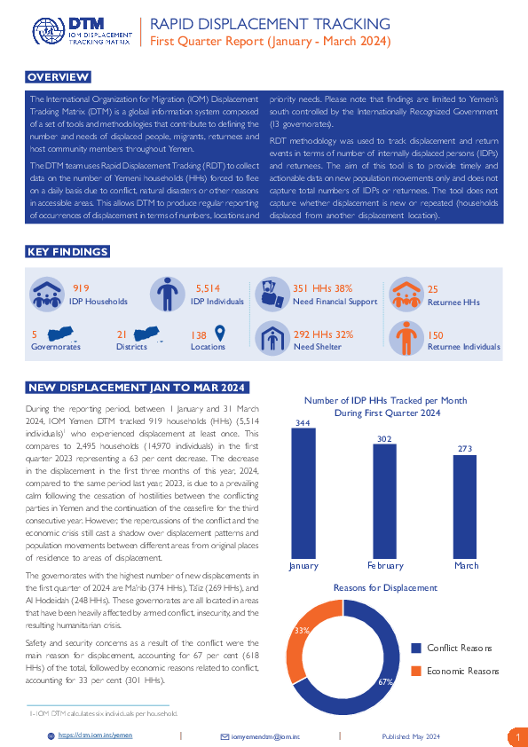
From 1 January to 31 March 2024, IOM Yemen DTM tracked 919 households (HH) (5,514 Individuals) who experienced displacement at least once.
Between 1 January and 31 March 2024, IOM Yemen DTM tracked 919 households (5514 individuals) displaced at least once. The majority of people moved into/within the following governorates and districts:
- Ma’rib (374 HHs) – Marib City (199 HHs), Marib (129 HHs), Harib (46 HHs) districts. Most displacements in the governorate originated from Marib and Al Hodeidah.
- Ta’iz (269 HHs) – Jabal Habashi (168 HHs), Al Makha (33 HHs), Al Maafer (24 HHs) districts. Most displacements in the governorate were internal.
- Al Hodeidah (248 HHs) – Al Khukhah (135 HHs), Hays (113 HHs) districts. Most displacements in the governorate originated from Al Hodeidah and Taiz.
The majority of people moved from the following governorates and districts:
- Ta’iz (360 HHs) – Jabal Habashi (16 HHs), Mawza (3 HHs), Hayfan (1 HH) districts.
- Al Hodeidah (248 HHs) – Bajil (6 HHs), As Sukhnah (5 HHs), Jabal Ras (1 HH) districts.
- Ma’rib (97 HHs) – Majzar (2 HHs), Al Jubah (1 HH) districts.
Population Groups
IDPs
Returnee (Previously Internally Displaced)
Survey Methodology
Unit of Analysis Or Observation
Admin Area 2
Household
Site or Location
Type of Survey or Assessment
Household
Key Informant
Keywords
Geographical Scope Partial Coverage
Administrative boundaries with available data
The current dataset covers the following administrative boundaries

Contact
DTM Yemen, iomyemendtm@iom.int
Language
English
Location
Yemen
Period Covered
Jan 01 2024
Mar 31 2024
Activity
- Mobility Tracking
- Event Tracking
During the reporting period, between 1 January and 31 March 2024, IOM Yemen DTM tracked 919 households (HHs) (5,514 individuals)1 who experienced displacement at least once. This compares to 2,495 households (14,970 individuals) in the first quarter 2023 representing a 63 per cent decrease. The decrease in the displacement in the first three months of this year, 2024, compared to the same period last year, 2023, is due to a prevailing calm following the cessation of hostilities between the conflicting parties in Yemen and the continuation of the ceasefire for the third consecutive year. However, the repercussions of the conflict and the economic crisis still cast a shadow over displacement patterns and population movements between different areas from original places of residence to areas of displacement.
The governorates with the highest number of new displacements in the first quarter of 2024 are Ma’rib (374 HHs), Ta’iz (269 HHs), and Al Hodeidah (248 HHs). These governorates are all located in areas that have been heavily affected by armed conflict, insecurity, and the resulting humanitarian crisis.
Safety and security concerns as a result of the conflict were the main reason for displacement, accounting for 67 per cent (618 HHs) of the total, followed by economic reasons related to conflict, accounting for 33 per cent (301 HHs).

Contact
DTM Niger, DTMNiger@iom.int
Language
English
Location
Niger
Period Covered
Nov 17 2023
Dec 18 2023
Activity
- Mobility Tracking
- Baseline Assessment
Depuis 2014 le Niger est touché par de multiples crises sécuritaires ainsi que des catastrophes récurrents qui ont causé le déplacement de
centaines de milliers de personnes à l’intérieur du pays. Diffa, Maradi, Tahoua et Tillaberi sont les régions les plus touchées par ces phénomènes
(insécurité et catastrophe). Jusqu’en 2024, les attaques des groupes armés ont continué à pousser les populations à fuir leurs localités pour trouver
refuge dans des zones plus stables. À cela s’ajoutent aussi les catastrophes (inondations, pluies torrentielles, etc.) qui touchent les populations
chaque année.
L’Organisation internationale pour les migrations (OIM) au Niger a mis en oeuvre la Matrice de suivi des déplacements (Displacement Tracking
Matrix, DTM en anglais) en 2016 en étroite collaboration avec le gouvernement du Niger pour collecter et diffuser des informations régulièrement
sur la population mobile afin d’offrir au gouvernement et aux partenaires humanitaires une meilleure compréhension des mouvements de
populations et des besoins changeants sur les lieux de déplacement ou de transit au Niger. L’outil DTM comporte quatre (4) composantes: le
suivi des mouvements de population, le suivi des flux migratoires, les enregistrements et les enquêtes. Pour apporter son appui au gouvernement
et aux partenaires humanitaires afin de mieux comprendre les tendances de déplacement et la situation des déplacés, l’OIM en collaboration
avec le Ministère de l’Action Humanitaire et de la Gestion des Catastrophes (MAH/GC) a mis en oeuvre la composante suivi des mouvements
de population depuis 2019, appelée « Évaluation des Villages » (Village Assessment Survey (VAS), en anglais).

Contact
DTM Support — iomdrcdtm@iom.int
Language
French
Location
Democratic Republic of the Congo
Period Covered
May 09 2024
May 19 2024
Activity
- Mobility Tracking
- Event Tracking
Le territoire de Kalehe, dans la partie nord de la province du Sud-Kivu, est confronté à une crise humanitaire aggravée par un conflit armé persistant. La crise actuelle du M23 dans la province du Nord-Kivu a encore compliqué la situation déjà instable, entraînant un déplacement massif de personnes du Nord-Kivu vers Kalehe et la fermeture de la route reliant Minova (Kalehe) au Nord-Kivu et à la capitale provinciale de Goma. La situation à Kalehe se caractérise par une détérioration de l'accès aux moyens de subsistance, tant pour les populations déplacées que pour les populations d'accueil, une aggravation des conditions de vie et des préoccupations croissantes en matière de protection. L'intensification des combats depuis le début du mois de mai 2024 dans le territoire de Masisi au Nord-Kivu (groupements de Mupfunyi Matanda, Mupfunyi-Kibabi, Mupfunyi-Shanga et Ufamandu) a entraîné des déplacements préventifs des populations locales vers le Sud-Kivu, en particulier vers les groupements de Mbinga-Nord, Buzi, Kalima et Ziralo. Les personnes déplacées se sont installées dans la communauté d'accueil ainsi que dans des centres collectifs à travers une région qui a déjà reçu plusieurs vagues de personnes déplacées au cours des derniers mois. Les systèmes d'aide humanitaire et communautaire sont de plus en plus sous pression dans les zones de refuge où l'assistance est très limitée et où les ressources disponibles localement dans le territoire de Kalehe sont insuffisantes. La situation sécuritaire dans la région reste imprévisible, limitant l'accès humanitaire dans la majeure partie du territoire de Kalehe, dans les groupements de Buzi, Ziralo et Alima.

Contact
DTM Support — iomdrcdtm@iom.int
Language
French
Location
Democratic Republic of the Congo
Period Covered
May 08 2024
May 12 2024
Activity
- Mobility Tracking
- Event Tracking
Depuis le début de l'année 2024, le niveau des rivières Moba et Mulobozi, y compris celui du lac Tanganyika, a fortement augmenté dans le territoire de Moba, province du Tanganyika, en raison de la persistance de fortes pluies. Cette situation continue de provoquer de fortes inondations, des glissements de terrain et de l'érosion, ainsi que des dommages importants aux maisons et aux biens dans la ville de Moba-Port et dans les villages situés tout au long de la rive du lac, sur l'axe Mpala-Moliro. Cette situation a provoqué des déplacements massifs de ménages vivant dans plusieurs localités dont celles de Tanganyika, Moba, Kituku, Port, Kinzungi, Kisi, Nkuba, Kitumba, Kansenge, et Kileba, avec une évaluation provisoire des dégâts de 3 360 maisons détruites. Il est fréquemment fait état de dégâts importants aux infrastructures publiques et privées, notamment à deux ports, huit écoles, des églises et des marchés, entre autres. La DTM estime que 4 119 ménages ont trouvé refuge dans des familles d'accueil à la fois dans les zones touchées par les inondations et dans celles qui ne le sont pas. Dans la plupart des cas, les conditions de vie sont très difficiles. Le risque de propagation de maladies transmises par l'eau, comme le choléra, constitue une menace sérieuse pour la santé publique dans la région. D'autres besoins prioritaires - notamment en matière d'abris, d'articles de première nécessité et de nourriture - nécessitant une action urgente et coordonnée se font sentir.

Contact
iomastana@iom.int iomalmaty@iom.int
Language
English
Location
Kazakhstan
Period Covered
Jan 01 2024
Jan 31 2024
Activity
- Survey
- Return Intention
- Mobility Tracking
- Baseline Assessment
The Mobility Tracking Matrix (MTM) is a system that tracks and monitors population mobility and displacement. MTM is adapted to the context in Kazakhstan based on IOM’s Global Displacement Tracking Matrix (DTM) methodology. DTM is designed to regularly and systematically capture, process, and disseminate information to provide a better understanding of the movements and evolving needs of mobile population groups, whether on-site or en route. MTM completed its first round of the Baseline Mobility Assessment (BMA) data collection on the district level in January 2023, the second round of BMA on the district level in May 2023, and the third round on the village level in December 2023. MTM enables IOM and its partners to maximize resources, set priorities, and deliver better-targeted, evidence-based, mobility-sensitive, and sustainable humanitarian and development programming.

Contact
DTM Cameroon, DTMCameroun@iom.int
Language
French
Location
Cameroon
Period Covered
May 22 2024
May 26 2024
Activity
- Mobility Tracking
- Event Tracking
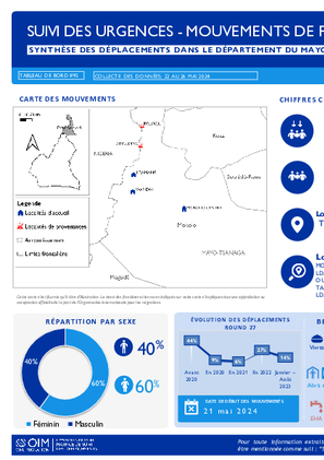
Le suivi des situations d’urgence (en anglais, Emergency Tracking Tool, ETT) est une des composantes de la Matrice de suivi des déplacements (en anglais, Displacement Tracking Matrix, DTM) déployée par l’Organisation Internationale pour les Migrations (OIM). Il a pour objectif de rassembler des informations sur les mouvements significatifs et soudains de populations, ainsi que sur des urgences sécuritaires et climatiques. Les données ont été collectées par observation directe et par des entretiens téléphoniques, auprès de dix informateurs clés, principalement des autorités locales, des organisations non-gouvernementales (ONG), des organisations de la société civile (OSC) et des représentants des populations dans les lieux affectés.
Ce tableau de bord présente des informations sur le déplacement de populations des localités de Tourou et Dinglding se sont déplacées vers les localités de Mokolo centre (Zimangayak, Ldamtsai Carrefour Dongoi, Ouro-Kessoum; Wayam-Tambak,Mendèzé) , Wandai et Ldamang dans l’arrondissement de Mokolo, département du Mayo-Tsanaga.
Contact
DTM Yemen, iomyemendtm@iom.int
Location
Yemen
Activity
- Mobility Tracking
- Event Tracking
Period Covered
May 19 2024 -May 25 2024
From 1 January to 25 May 2024, IOM Yemen DTM tracked 1,358 households (HH) (8,148 Individuals) who experienced displacement at least once.
Between 19 and 25 May 2024, IOM Yemen DTM tracked 41 households (246 individuals) displaced at least once. The majority of people moved into/within the following governorates and districts:
- Ma’rib (18 HHs) – Ma’rib City (14 HHs), Ma’rib (4 HHs) districts. Most displacements in the governorate originated from Al Hodeidah and Al Jawf.
- Al Hodeidah (14 HHs) – Al Khukhah (8 HHs), Hays (6 HHs) districts. Most displacements in the governorate originated from Al Hodeidah and Ta’iz.
- Ta’iz (8 HHs) – Jabal Habashi (8 HHs) district. All displacements in the governorate were internal.
The majority of people moved from the following governorates and districts:
- Al Hodeidah (15 HHs) – At Tuhayta (9 HHs), Hays (3 HHs), Al Marawiah (1 HH) districts.
- Ta’iz (14 HHs) – Al Maafer (6 HHs), Maqbanah (5 HHs), Ash Shamayatayn (1 HH) districts.
- Al Jawf (2 HHs) – Al Hazm (2 HHs) district.
Population Groups
IDPs
Returnee (Previously Internally Displaced)
Survey Methodology
Unit of Analysis Or Observation
Admin Area 2
Household
Site or Location
Type of Survey or Assessment
Household
Key Informant
Keywords
Geographical Scope Partial Coverage
Administrative boundaries with available data
The current dataset covers the following administrative boundaries
Pagination
- Previous page
- Page 78
- Next page
