-
Countries
-
Data and Analysis
-
Special Focus
-
Crisis Responses
Other

Contact
abate@iom.int
Language
English
Location
Saint Vincent and the Grenadines
Snapshot Date
Jul 29 2024
Activity
- Other
- 73% of buildings were destroyed or damaged.
- 27% of buildings were moderately or possibly damaged.

Contact
abate@iom.int
Language
English
Location
Saint Vincent and the Grenadines
Snapshot Date
Jul 29 2024
Activity
- Other
- 73% of buildings were destroyed or damaged.
- 27% of buildings were moderately or possibly damaged.

Contact
abate@iom.int
Language
English
Location
Saint Vincent and the Grenadines
Snapshot Date
Jul 29 2024
Activity
- Other
- 73% of buildings were destroyed or damaged.
- 27% of buildings were moderately or possibly damaged.

Contact
abate@iom.int
Language
English
Location
Saint Vincent and the Grenadines
Period Covered
Jul 03 2024
Jul 11 2024
Activity
- Other
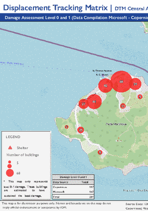
Overview: Following Hurricane Beryl’s landfall on 1 July 2024, a damage assessment was conducted in Union Island (SVG), Carriacou (Grenada), and Petite Martinique (Grenada) to estimate building damage. The assessment utilized satellite imagery from Copernicus (3 and 5 July 2024) and Microsoft Footprints (3, 9, and 11 July 2024).
The percentage of buildings destroyed or damaged across the assessed locations in Saint Vincent and the Grenadines is as follows:
Union Island (SVG):
- 73% of buildings were destroyed or damaged.
- 27% of buildings were moderately or possibly damaged.
Pagination
- Previous page
- Page 2
- Next page


