-
Countries
-
Data and Analysis
-
Special Focus
-
Crisis Responses
Event Tracking

Contact
DTM Nigeria, iomnigeriadtm@iom.int
Language
English
Location
Nigeria
Snapshot Date
Aug 11 2023
Activity
- Mobility Tracking
- Event Tracking
On 10 August 2023, heavy rainfall struck International Secondary School and Zullum camps in Ngala LGA of Borno State, which affected a total of 2,472 individuals from 533 households. The incidents damaged 381 shelters, 22 latrines and 23 showers.
In response to these events, the DTM (Displacement Tracking Matrix) field team swiftly conducted evaluations to inform the humanitarian community, the government, and partners and to facilitate a targeted response. The field team utilized direct observation and key informant interviews in flash reports to collect representative data and determine the quantity and immediate needs of the affected groups.
Contact
DTM Nigeria, iomnigeriadtm@iom.int
Language
English
Location
Nigeria
Snapshot Date
Sep 28 2023
Activity
- Mobility Tracking
- Event Tracking
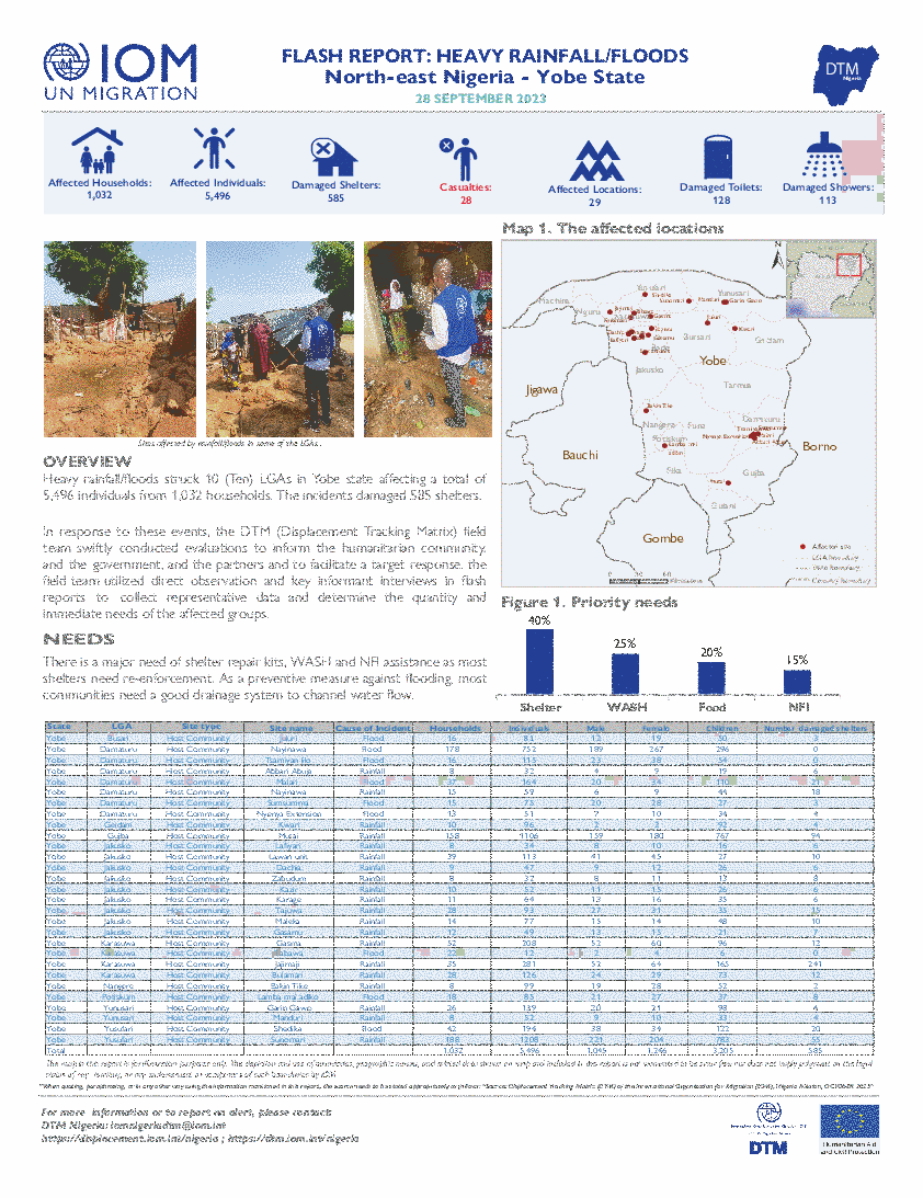
Heavy rainfall/floods struck 10 (Ten) LGAs in Yobe state affecting a total of 5,496 individuals from 1,032 households. The incidents damaged 585 shelters.
In response to these events, the DTM (Displacement Tracking Matrix) field team swiftly conducted evaluations to inform the humanitarian community, and the government, and the partners and to facilitate a target response. the field team utilized direct observation and key informant interviews in flash reports to collect representative data and determine the quantity and immediate needs of the affected groups.
Contact
DTM Nigeria, iomnigeriadtm@iom.int
Language
English
Location
Nigeria
Period Covered
Oct 05 2023
Oct 09 2023
Activity
- Mobility Tracking
- Event Tracking
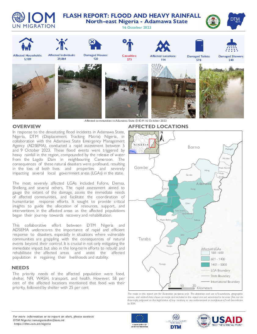
In response to the devastating flood incidents in Adamawa State, Nigeria, DTM (Displacement Tracking Matrix) Nigeria, in collaboration with the Adamawa State Emergency Management Agency (ADSEMA), conducted a rapid assessment between 5 and 9 October 2023. These flood events were triggered by heavy rainfall in the region, compounded by the release of water from the Lagdo Dam in neighbouring Cameroon. The consequences of these natural disasters were profound, resulting in the loss of both lives and properties and severely impacting several local government areas (LGAs) in the state.
The most severely affected LGAs included Fufore, Demsa, Shelleng, and several others. The rapid assessment aimed to gauge the extent of the damage, assess the immediate needs of affected communities and facilitate the coordination of humanitarian response efforts. It sought to provide critical insights to guide the allocation of resources, support, and interventions in the affected areas as the affected populations began their journey towards recovery and rehabilitation.
Contact
DTMCostaRica@iom.int
Language
Spanish
Location
Costa Rica
Period Covered
Sep 01 2023
Sep 30 2023
Activity
- Flow Monitoring
- Mobility Tracking
- Event Tracking
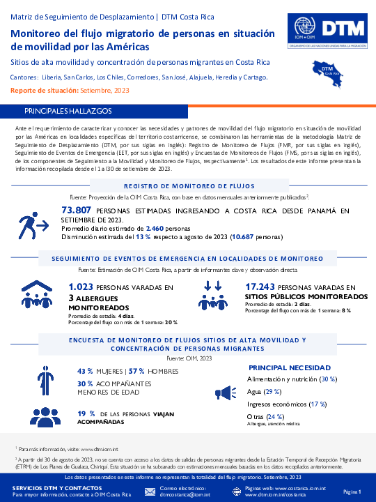
Cantones: Liberia, Los Chiles, San Carlos, Heredia, Alajuela, Cartago, San José y Corredores.
Costa Rica, al igual que los demás países de la región centroamericana, se ha caracterizado por ser un corredor migratorio para personas que transitan de manera terrestre desde el sur hasta el norte de América y que tienen como destino los países del norte del continente. Este flujo en situación de movilidad por las Américas se encuentra compuesto principalmente por personas de la República Bolivariana de Venezuela, Cuba, Haití, Ecuador, así como personas provenientes de otros países de Suramérica, África y Asia.
Según estimaciones de la OIM Costa Rica, durante setiembre ingresaron al país 73.087 personas, un promedio de 2460 personas por día y estimando una disminución de un 13% con respecto a agosto de 2023. Además, se identificaron 1.023 personas varadas en los albergues monitoreados y 17.243 personas varadas en los sitios públicos visitados.
Contact
DTM Chad, dtmtchad@iom.int
Language
English
Location
Chad
Period Covered
Aug 01 2023
Oct 09 2023
Activity
- Mobility Tracking
- Event Tracking
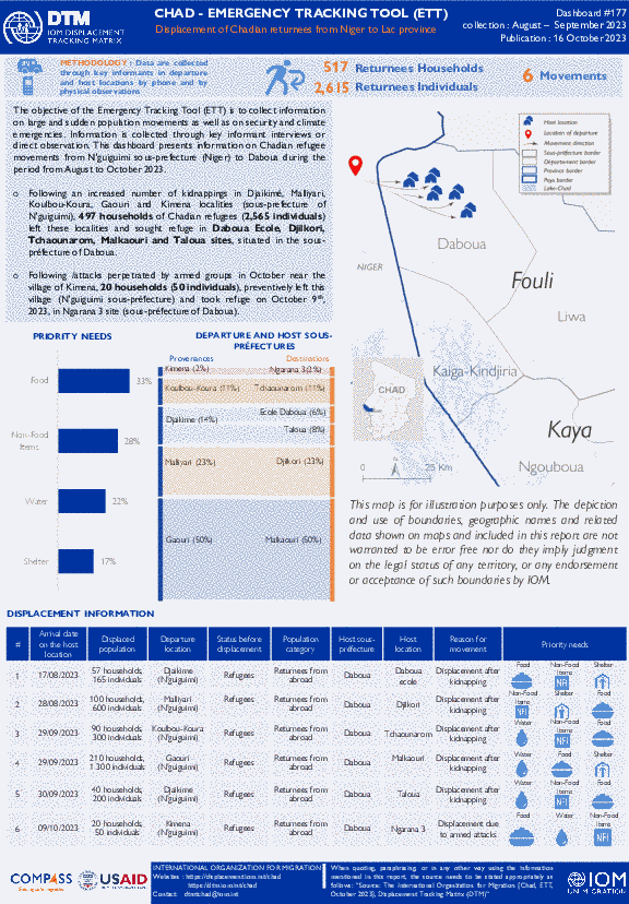
The objective of the Emergency Tracking Tool (ETT) is to collect information on large and sudden population movements as well as on security and climate emergencies. Information is collected through key informant interviews or direct observation. This dashboard presents information on Chadian refugee movements from N'guiguimi sous-prefecture (Niger) to Daboua during the period from August to October 2023.
- Following an increased number of kidnappings in Djaikimé, Malliyari, Koulbou-Koura, Gaouri and Kimena localities (sous-prefecture of N'guiguimi), 497 households of Chadian refugees (2,565 individuals) left these localities and sought refuge in Daboua Ecole, Djilkori, Tchaounarom, Malkaouri and Taloua sites, situated in the sous-préfecture of Daboua.
- Following /attacks perpetrated by armed groups in October near the village of Kimena, 20 households (50 individuals), preventively left this village (N'guiguimi sous-préfecture) and took refuge on October 9 th , 2023, in Ngarana 3 site (sous-préfecture of Daboua).

Contact
DTM Chad, dtmtchad@iom.int
Language
English
Location
Chad
Period Covered
Sep 01 2023
Sep 30 2023
Activity
- Mobility Tracking
- Event Tracking
The purpose of the Emergency Tracking Tool (ETT) is to collect information on large and sudden population movements as well as on security and climate emergencies. Information is collected through key informant interviews or direct observation. This dashboard provides information on movements which occurred during the period from 01 to 30 September 2023, in the Lac Province.
During September 2023, several security incidents occurred in the Lac province and beyond (Niger), resulting in population displacements. A total of 3,546 households (12,627 individuals) were affected by displacement, which represents an increase of 43 per cent compared to August. Among the displaced population, 340 households (1,800 individuals) Chadian refugees who were forced to leave the sous-préfecture of N'guiguimi (Niger) for Daboua sous-préfecture. The vast majority (86%) of affected individuals during September were members of local communities before this displacement. The main reason for displacement was armed attacks (82%). The majority (65%) of displaced persons stayed in the same sous-préfectures (see table on page 2). The three essential needs reported by most displaced persons at their places of displacement were food (29%), non-food items (29%), shelter (23%) and water (19%).
Contact
DTM Yemen, iomyemendtm@iom.int
Location
Yemen
Activity
- Mobility Tracking
- Event Tracking
Period Covered
Oct 08 2023 -Oct 14 2023
From 1 January to 14 October 2023, IOM Yemen DTM tracked 4,716 households (HH) (28,296 Individuals) who experienced displacement at least once.
Between 8 and 14 October 2023, IOM Yemen DTM tracked 24 households (144 individuals) displaced at least once. The majority of people moved into/within the following governorates and districts:
- Ma’rib (12 HHs) – Ma’rib City (7 HHs), Harib (3 HHs), Ma’rib (2 HHs) districts. Most displacements in the governorate originated from Ibb and Al Hodeidah.
- Al Hodeidah (8 HHs) – Al Khukhah (6 HHs), At Tuhayta (2 HHs) districts. Most displacements in the governorate were internal.
- Hadramawt (4 HHs) – Ash Shihr (4 HHs) district. All displacements in the governorate originated from Al Hodeidah.
- Al Hodeidah (13 HHs) – Bayt Al Faqih (5 HHs), At Tuhayta (4 HHs), Al Khukhah (1 HH) districts.
- Ibb (5 HHs) – Dhi As Sufal (3 HHs), Al Odayn (2 HHs) districts.
- Ta’iz (3 HHs) – Jabal Habashi (2 HHs), Mawza (1 HH) districts.
Population Groups
Survey Methodology
Unit of Analysis Or Observation
Type of Survey or Assessment
Keywords
Geographical Scope
Administrative boundaries with available data
The current dataset covers the following administrative boundaries
Contact
DTM CAR, DTMRCA@iom.int
Language
English
Location
Central African Republic
Period Covered
Aug 01 2023
Sep 08 2023
Activity
- Mobility Tracking
- Site Assessment
- Event Tracking
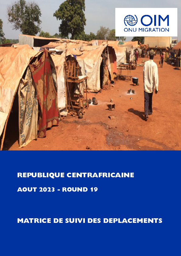
Ce rapport fournit un aperçu des déplacements et des besoins humanitaires multisectoriels dans les localités d’accueil des personnes déplacées internes (PDI) et / ou retournées. Les résultats ont été obtenus après la conduite du dix-neuvième cycle de suivi des déplacements (round 19) réalisé entre le 01er août et le 08 septembre 2023 par l’Organisation Internationale pour les Migrations (OIM) grâce au soutien du Bureau pour l’Assistance Humanitaire (en anglais, Bureau for Humanitarian Assistance, BHA), la Direction Générale de la Protection Civile et des Opérations d’Aide Humanitaire Européennes (DG ECHO) et le Fonds Humanitaire (FH). L’évaluation a couvert 4 2241 localités d’accueil des PDI et / ou retournés et 79 sites de déplacement identifiés préalablement avec les autorités locales. Les données ont été collectées au moyen de deux questionnaires structurés multisectoriels (un déployé au niveau des localités et un déployé au niveau des sites) auprès d’informateurs clés incluant des représentants de déplacés, les leaders communautaires et des gestionnaires de sites. L’évaluation a couvert les 16 préfectures du pays et la ville de Bangui.

Contact
DTM DRC, iomdrcdtm@iom.int
Language
French
Location
Democratic Republic of the Congo
Period Covered
Sep 24 2023
Oct 09 2023
Activity
- Event Tracking
Depuis le début de la crise M23, l'OIM, par le biais de la DTM continue à mener une série d'évaluations rapides, y compris le suivi des situations d’urgence (EET/ERM), l'analyse des crises et enregistrement avec priorité de répondre aux besoins immédiats d'information en vue de comprendre la dynamique des déplacements et les besoins. Ce rapport présente les résultats des évaluations menées dans les différentes zones de déplacement et de retour entre le 24 septembre au 9 octobre 2023.
Le suivi de la crise depuis fin septembre a permis à la DTM de mettre à jour les données de déplacement, identifiant un total de 824 381 personnes déplacées affectées par la crise du M2. Au total, 100 pour cent de ces personnes déplacées se trouvent dans la province du Nord-Kivu et sont réparties entre les familles d'accueil, les sites spontanés et les sites sous le mécanisme CCCM. Concernant les PDIs dans les familles d’accueil, le territoire de Masisi est le plus touché par les déplacements avec 39 pour cent des ces personnes déplacées, suivi de Rutshuru avec 30 pour cent, Lubero avec 13, et Walikale avec six pour cent. Le nombre de personnes déplacées dans ce cycle d'évaluation montre une nette augmentation de 233 595 individus (40%) par rapport aux données cumulées de l'évaluation d'août 2023, dont 590 786 personnes déplacées ont été signalées.
Contact
DTM Burundi, DTMBurundi@iom.int
Location
Burundi
Activity
- Mobility Tracking
- Event Tracking
Period Covered
Oct 01 2023 -Oct 07 2023
La DTM a identifié 2,008 personnes affectées dont 374 personnes déplacées par les vents violents et des pluies torrentielles dans les provinces de Cibitoke et Kirundo.
A more detailed version of this dataset is available, to get access kindly click on the 'Request Access' button.
Population Groups
Survey Methodology
Unit of Analysis Or Observation
Type of Survey or Assessment
Keywords
Geographical Scope
Administrative boundaries with available data
The current dataset covers the following administrative boundaries
Pagination
- Previous page
- Page 59
- Next page
