-
Countries
-
Data and Analysis
-
Special Focus
-
Crisis Responses
Event Tracking

Contact
DTM Mozambique, DTMMozambique@iom.int
Language
English
Location
Mozambique
Period Covered
Apr 22 2024
Apr 24 2024
Activity
- Other
- Mobility Tracking
- Event Tracking
- Site Assessment
The Displacement Tracking Matrix (DTM), in collaboration with Mozambique’s National Institute for Disaster Management (INGD), conducted assessments in Maringue, Chemba, and Barue to record displacements caused by severe El Niño induced drought conditions. Mozambique's National Meteorological Institute (INAM) project decreased precipitation levels and drought conditions across districts in Central and Southern Mozambique - potentially impacting over 20 million people. El- Niño induced drought, land degradation and increased salinity in important water sources continue to place a strain on the agriculture, livestock herding and fishing industries, with many families unable to guarantee sufficient and sustainable livelihoods in rural areas.
DTM’s tracking of climate-induced displacement aims to provide data on the number and location of vulnerable families forced into displacement due to climatic and environmental factors. Joint assessments conducted between 22-24 April estimate 342 individuals (58 families) displaced from Northern Sofala and Tete districts to host communities of Manica (Barue district). Priority needs identified by IDPs include food security, access to clean water, adequate shelter, and agricultural inputs. Additionally, there is a pressing demand for non-food items such as hygiene kits, blankets, mosquito nets, and kitchen sets.

Contact
DTMMozambique@iom.int
Language
English
Location
Mozambique
Period Covered
May 10 2024
May 17 2024
Activity
- Mobility Tracking
- Event Tracking
Between 10 to 17 May 2024, attacks, and fear of attacks by Non-state Armed Groups in Macomia triggered the cumulative displacement of 3,106 individuals/ 1,021 families. The current Movement Alert #113 reports on most recent attacks in Northen Cabo Delgado. For more information on displacements between January and April, please see {Emergency Tracking Online Dashboard}.

Contact
DTM Support — iomdrcdtm@iom.int
Language
French
Location
Democratic Republic of the Congo
Period Covered
May 04 2024
May 12 2024
Activity
- Mobility Tracking
- Event Tracking
Depuis le début d’avril 2024, la région des Hauts-Plateaux du territoire de Fizi, située dans la province du Sud-Kivu, est le théâtre d’un conflit persistant opposant deux factions du groupe armé Biloze Bishambuke. Les habitants des villages de cette zone, tels que Bishaka, Bishakara, Kabanja, Kitumba, Kwamashaka et Ruhemba, ont été contraints de quitter de force leurs foyers en raison de ces événements. Après avoir temporairement trouvé refuge dans le groupement de Basikalanga, ces personnes déplacées ont malheureusement dû fuir une nouvelle fois en raison de la persistance du conflit. Depuis la fin d’avril 2024, cette population déplacée se retrouve désormais dans les villages des groupements de Babungwe Sud, Basimukuma Sud, Balala Nord et Balala Sud, toujours dans le territoire de Fizi.
Le déplacement de population a touché 5 759 ménages, soit un total de 29 946 individus répartis dans quatre villages/localités d’accueil. Parmi eux, on compte 2 078 ménages déplacés, regroupant 10x806 individus à Sebele, 602 ménages avec 3 130 individus à Malinde, 2 727 ménages comprenant 14 180 individus à Katanga et enfin, 352 ménages abritant 1 830 individus à Lusenda. Ces villages sont situés dans les secteurs de Mutambala et Tanganyika, dans le territoire de Fizi, province du Sud-Kivu.

Contact
DTM Support — iomdrcdtm@iom.int
Language
French
Location
Democratic Republic of the Congo
Period Covered
May 04 2024
May 11 2024
Activity
- Mobility Tracking
- Event Tracking
Depuis le début de l’année 2024, la partie côtière du territoire de Fizi a été touchée par des inondations causées par la montée des eaux du lac Tanganyika et le débordement des rivières Mutambala et Luke, entraînant le déplacement de nombreuses personnes. La situation s’est aggravée au début du mois d’avril en raison de fortes pluies, provoquant des inondations qui ont affecté plusieurs villages du groupement de Basimukinji dans le territoire de Fizi. Ces événements ont engendré d’importantes destructions matérielles, des pertes considérables et ont malheureusement entraîné des décès signalés. En conséquence, environ 4 038 ménages et 25 383 individus ont été contraints de chercher refuge dans les villages d’accueil de Baraka et Mwangaza du groupement Basimukinji, ainsi que dans ceux de Mboko et Makobola du groupement de Babungwe Nord.
La situation a provoqué d’importantes perturbations sur la Route Nationale N°5 (axe Kikongo – Makobola), entraînant une forte congestion du trafic routier. De plus, elle a eu un impact significatif sur la sécurité alimentaire des zones d’accueil, avec environ 12 pour cent des terres agricoles de la région touchées par les inondations. Les voies d’approvisionnement vers les grandes agglomérations comme Bukavu et Uvira sont de plus en plus perturbées, engendrant ainsi une pénurie alimentaire dans ces régions.

Contact
DTMCostaRica@iom.int
Language
English
Location
Costa Rica
Period Covered
Apr 01 2024
Apr 30 2024
Activity
- Flow Monitoring
- Mobility Tracking
- Event Tracking
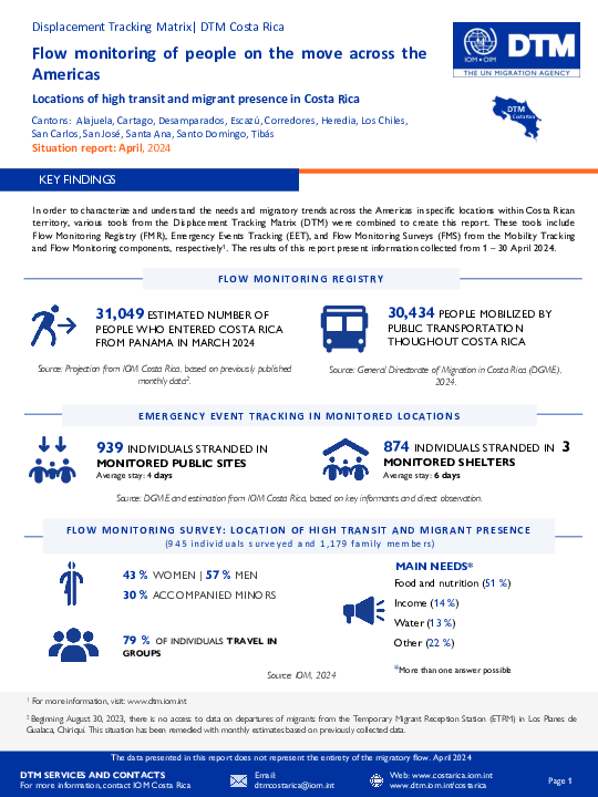
Cantons: Alajuela, Alajuelita, Cartago, Desamparados, Escazú, Corredores, Heredia, Los Chiles, San Carlos, San José, Santa Ana, Santo Domingo, Tibás
Costa Rica, like the other countries in the Central American region, has been characterized as a migratory corridor for people who transit by land from the south to the north of America and whose destination is the countries in the north of the continent. This flow on the move through the Americas is mainly made up of people from the Bolivarian Republic of Venezuela, Cuba, Haiti, Ecuador, as well as people from other countries in South America, Africa and Asia.
According to estimations from IOM Costa Rica, during April 31,049 people entered the country, an approximate average of 1,035 people per day and estimating a decrease of 14% compared to March 2024. In addition, 874 people stranded in the monitored shelters were identified and 939 people stranded in the public places visited.
Contact
DTM Yemen, iomyemendtm@iom.int
Location
Yemen
Activity
- Mobility Tracking
- Event Tracking
Period Covered
May 12 2024 -May 18 2024
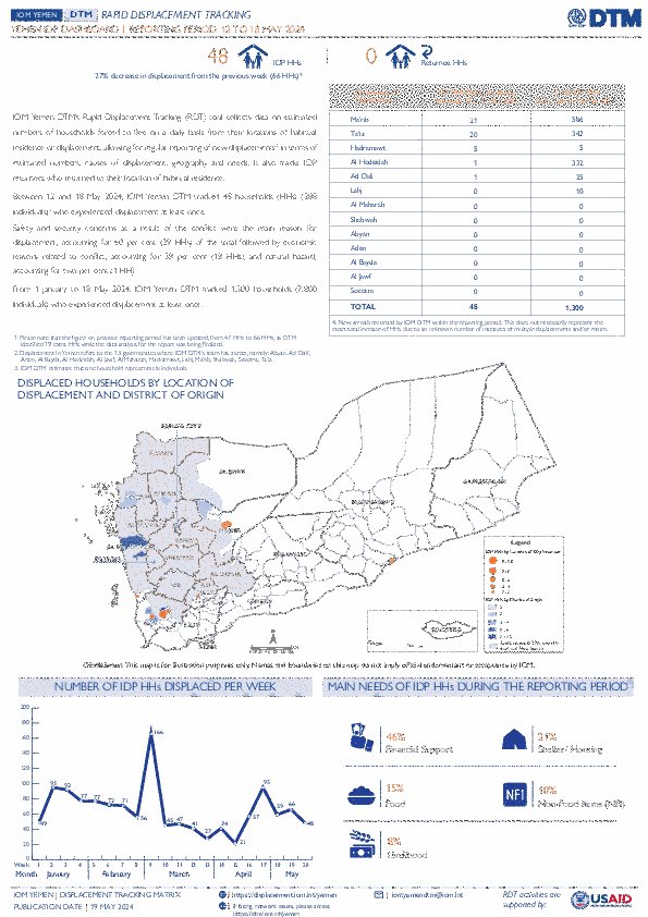
From 1 January to 18 May 2024, IOM Yemen DTM tracked 1,300 households (HH) (7,800 Individuals) who experienced displacement at least once .
Between 12 and 18 May 2024, IOM Yemen DTM tracked 48 households (288 individuals) displaced at least once. The majority of people moved into/within the following governorates and districts:
- Ma’rib (21 HHs) – Ma’rib City (15 HHs), Ma’rib (6 HHs) districts. Most displacements in the governorate originated from Al Hodeidah and Ta’iz.
- Ta’iz (20 HHs) – Jabal Habashi (15 HHs), Mawza (3 HHs), Al Misrakh (2 HHs) districts. Most displacements in the governorate were internal.
- Hadramawt (5 HHs) – Al Mukalla City (5 HHs) district. All displacements in the governorate originated from Al Hodeidah.
The majority of people moved from the following governorates and districts:
- Ta’iz (22 HHs) – Jabal Habashi (16 HHs), Mawza (3 HHs), Hayfan (1 HH) districts.
- Al Hodeidah (13 HHs) – Bajil (6 HHs), As Sukhnah (5 HHs), Jabal Ras (1 HH) districts.
- Ma’rib (3 HHs) – Majzar (2 HHs), Al Jubah (1 HH) districts.
Population Groups
IDPs
Returnee (Previously Internally Displaced)
Survey Methodology
Unit of Analysis Or Observation
Admin Area 2
Household
Type of Survey or Assessment
Household
Key Informant
Keywords
Geographical Scope Partial Coverage
Administrative boundaries with available data
The current dataset covers the following administrative boundaries

Contact
DTM Yemen, iomyemendtm@iom.int
Language
English
Location
Yemen
Period Covered
May 12 2024
May 18 2024
Activity
- Mobility Tracking
- Event Tracking
IOM Yemen DTM’s Rapid Displacement Tracking (RDT) tool collects data on estimated numbers of households forced to flee on a daily basis from their locations of origin or displacement, allowing for regular reporting of new displacements in terms of estimated numbers, geography, and needs. It also tracks returnees who returned to their location of origin.
From 1 January to 18 May 2024, IOM Yemen DTM tracked 1,300 households (HH) (7,800 Individuals) who experienced displacement at least once .
Between 12 and 18 May 2024, IOM Yemen DTM tracked 48 households (288 individuals) displaced at least once. The majority of people moved into/within the following governorates and districts:
- Ma’rib (21 HHs) – Ma’rib City (15 HHs), Ma’rib (6 HHs) districts. Most displacements in the governorate originated from Al Hodeidah and Ta’iz.
- Ta’iz (20 HHs) – Jabal Habashi (15 HHs), Mawza (3 HHs), Al Misrakh (2 HHs) districts. Most displacements in the governorate were internal.
- Hadramawt (5 HHs) – Al Mukalla City (5 HHs) district. All displacements in the governorate originated from Al Hodeidah.
The majority of people moved from the following governorates and districts:
- Ta’iz (22 HHs) – Jabal Habashi (16 HHs), Mawza (3 HHs), Hayfan (1 HH) districts.
- Al Hodeidah (13 HHs) – Bajil (6 HHs), As Sukhnah (5 HHs), Jabal Ras (1 HH) districts.
- Ma’rib (3 HHs) – Majzar (2 HHs), Al Jubah (1 HH) districts.
IOM identified 19 additional households displaced in the previous reporting period, which covered 05 - 11 May 2024, in the governorates of Ma’rib (7 HHs), Al Hodeidah (6 HHs), and Ta’iz (6 HHs). These figures have been added to the cumulative displacement total recorded since the beginning of the year.

Contact
DTMMozambique@iom.int
Language
English
Location
Mozambique
Period Covered
May 10 2024
May 14 2024
Activity
- Mobility Tracking
- Event Tracking
Between 10 to 14 May 2024, attacks, and fear of attacks by Non-state Armed Groups in Macomia triggered the cumulative displacement of 1,461 individuals/ 537 families. The current Movement Alert #112 reports on most recent attacks in Northen Cabo Delgado. For more information on displacements between January and April, please see {Emergency Tracking Online Dashboard}.
Contact
DTM Somalia Location
Somalia
Activity
- Mobility Tracking
- Event Tracking
Period Covered
Mar 30 2024 -Nov 13 2024
This latest round of Emergency Trends Tracking was initiated in April 2024 to monitor displacement movements during the Gu rainy season. From April to September 2024, DTM teams collected data in up to 22 districts: Afgooye, Afmadow, Baardheere, Baidoa, Balcad, Belet Weyne, Belet Xaawo, Cabudwaaq, Dayniile, Dhuusamarreeb, Doolow, Gaalkacyo, Garoowe, Hobyo, Hodan, Jamaame, Jowhar, Kahda, Kismaayo, Luuq, Waajid, and Xudur. Starting week 28, data collection occurred in the 4 districts: Waajid and Xudur districts in Bakool region and Gaalkacyo and Hobyo districts in Mudug region.
ETT is a crisis-based tool that tracks sudden displacement triggered by specific events or emerging crises. The objective of ETT is to help prioritize humanitarian response and to enable partners to deliver rapid assistance. Based on previous shock-induced displacement patterns, the humanitarian community expects that people will continue to move toward urban areas in search of humanitarian services. Consequently, the ETT coverage focuses on the main urban centers and surrounding villages for each assessed district. The data is collected through Key Informant Interviews (KIIs) at the location level, from Saturday to Wednesday, every week. It includes information on new arrivals, numbers and demographic of IDPs, reasons for displacement, intentions, humanitarian assistance and priority needs among others.
To facilitate the joint analysis of the CCCM (Camp Coordination and Camp Management) Cluster’s New Arrivals Tracker (NAT) and ETT data, the assistance and needs indicators are identical in both tools.
Population Groups
IDPs
Survey Methodology
Unit of Analysis Or Observation
Site or Location
Type of Survey or Assessment
Key Informant
Keywords
Geographical Scope Partial Coverage
Administrative boundaries with available data
The current dataset covers the following administrative boundaries
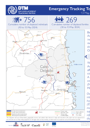
Between 10 to 12 May 2024, attacks, and fear of attacks by Non-state Armed Groups in Macomia triggered the cumulative displacement of 756 individuals/ 269 families. The current Movement Alert #111 reports on most recent attacks in Northen Cabo Delgado. For more information on displacements between February and April, please see {Emergency Tracking Online Dashboard}.
Pagination
- Previous page
- Page 30
- Next page

