Site Assessment
Jul 03 2023
- Mobility Tracking
- Site Assessment
- Baseline Assessment
- Village Assessment
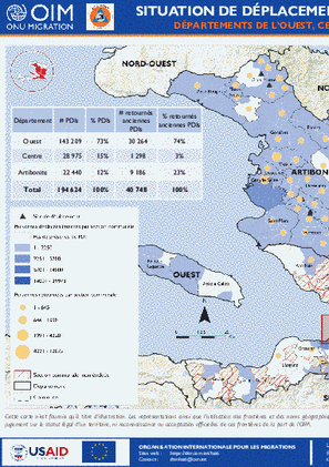
Au cours des dernières années, l’insécurité généralisée en Haïti a poussé des milliers de personnes à fuir leurs zones de résidence. Bien que les violences surviennent le plus souvent dans la Zone Métropolitaine de Port-au-Prince (ZMPP) située dans le département de l’Ouest, d’autres départements sont aussi affectés. Ceci est notamment le cas de départements du Centre et de l'Artibonite.
Afin d’informer régulièrement les autorités ainsi que d’autres partenaires sur la situation de déplacement dans les départements de l'Ouest, du Centre et de l'Artibonite, la Direction Générale de la Protection Civile (DGPC) et la matrice de suivi des déplacements (DTM) de l’OIM ont mené en juin 2023 des activités d’évaluations dans les sections communales, quartiers et sites accueillant les populations déplacées dans ces départements.
Ce tableau de bord présente la synthèse de résultats issus de ces collectes de données
- Mobility Tracking
- Site Assessment
Dec 31 2022
Population Groups
Survey Methodology
Unit of Analysis Or Observation
Type of Survey or Assessment
Keywords
Geographical Scope
Administrative boundaries with available data
The current dataset covers the following administrative boundaries
- Mobility Tracking
- Site Assessment
Oct 31 2022
Population Groups
Survey Methodology
Unit of Analysis Or Observation
Type of Survey or Assessment
Keywords
Geographical Scope
Administrative boundaries with available data
The current dataset covers the following administrative boundaries

Jun 08 2023
- Mobility Tracking
- Site Assessment
- Event Tracking
Ce rapport fournit un aperçu des déplacements et des besoins humanitaires multisectoriels dans les localités d’accueil des personnes déplacées internes (PDI) et / ou retournées. Les résultats ont été obtenus après la conduite du dix-huitième cycle de suivi des déplacements (round 18) réalisé entre le 01er mai et le 08 juin 2023 par l’Organisation Internationale pour les Migrations (OIM) grâce au soutien du Bureau pour l’Assistance Humanitaire (en anglais, Bureau for Humanitarian Assistance, BHA), la Direction Générale de la Protection Civile et des Opérations d’Aide Humanitaire Européennes (DG ECHO) et le Fonds Humanitaire (FH). L’évaluation a couvert 4 2001 localités d’accueil des PDI et / ou retournés et 78 sites de déplacement identifiés préalablement avec les autorités locales et avec le suivi du Ministère de l’Action Humanitaire et de la Réconcilation Nationale.
Dec 31 2022
- Mobility Tracking
- Site Assessment
- Baseline Assessment
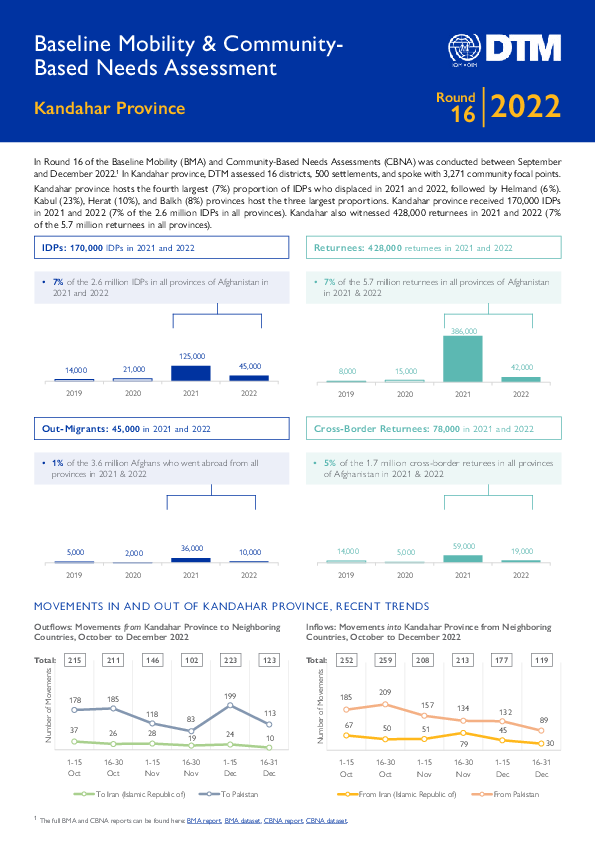
DTM has been conducting the Baseline Mobility Assessment (BMA) in Afghanistan since 2016 to track mobility, provide information on population estimates, locations and geographic distribution of displaced and returnee populations, reasons for displacement, places of origin and periods of displacement. The Community-Based Needs Assessment (CBNA) provides a comprehensive overview of the evolving vulnerabilities and multisectoral needs in communities hosting internally displaced persons (IDPs) and returnees from abroad.
Data is collected at the settlement level through focus group discussions with community focal points and direct observation. The figures presented in the report are estimates provided by community focal points.
This factsheet delves into the key findings in Kandahar province using the latest results from Round 16 (Sep to Dec 2022) of the BMA and CBNA, focusing on the 2021-to-2022 period.
The full report can be found here: Baseline Mobility Assessment and Community-Based Needs Assessment.
Dec 31 2022
- Mobility Tracking
- Site Assessment
- Baseline Assessment
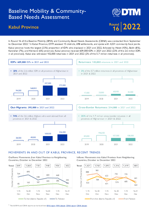
DTM has been conducting the Baseline Mobility Assessment (BMA) in Afghanistan since 2016 to track mobility, provide information on population estimates, locations and geographic distribution of displaced and returnee populations, reasons for displacement, places of origin and periods of displacement. The Community-Based Needs Assessment (CBNA) provides a comprehensive overview of the evolving vulnerabilities and multisectoral needs in communities hosting internally displaced persons (IDPs) and returnees from abroad.
Data is collected at the settlement level through focus group discussions with community focal points and direct observation. The figures presented in the report are estimates provided by community focal points.
This factsheet delves into the key findings in Kabul province using the latest results from Round 16 (Sep to Dec 2022) of the BMA and CBNA, focusing on the 2021-to-2022 period.
The full report can be found here: Baseline Mobility Assessment and Community-Based Needs Assessment.

Dec 31 2022
- Mobility Tracking
- Site Assessment
- Baseline Assessment
DTM has been conducting the Baseline Mobility Assessment (BMA) in Afghanistan since 2016 to track mobility, provide information on population estimates, locations and geographic distribution of displaced and returnee populations, reasons for displacement, places of origin and periods of displacement. The Community-Based Needs Assessment (CBNA) provides a comprehensive overview of the evolving vulnerabilities and multisectoral needs in communities hosting internally displaced persons (IDPs) and returnees from abroad.
Data is collected at the settlement level through focus group discussions with community focal points and direct observation. The figures presented in the report are estimates provided by community focal points.
This factsheet delves into the key findings in Herat province using the latest results from Round 16 (Sep to Dec 2022) of the BMA and CBNA, focusing on the 2021-to-2022 period.
The full report can be found here: Baseline Mobility Assessment and Community-Based Needs Assessment.
Dec 31 2022
- Mobility Tracking
- Site Assessment
- Baseline Assessment
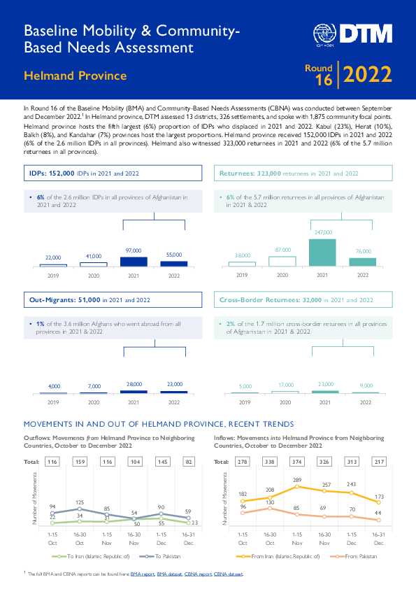
DTM has been conducting the Baseline Mobility Assessment (BMA) in Afghanistan since 2016 to track mobility, provide information on population estimates, locations and geographic distribution of displaced and returnee populations, reasons for displacement, places of origin and periods of displacement. The Community-Based Needs Assessment (CBNA) provides a comprehensive overview of the evolving vulnerabilities and multisectoral needs in communities hosting internally displaced persons (IDPs) and returnees from abroad.
Data is collected at the settlement level through focus group discussions with community focal points and direct observation. The figures presented in the report are estimates provided by community focal points.
This factsheet delves into the key findings in Helmand province using the latest results from Round 16 (Sep to Dec 2022) of the BMA and CBNA, focusing on the 2021-to-2022 period.
The full report can be found here: Baseline Mobility Assessment and Community-Based Needs Assessment.
Dec 31 2022
- Mobility Tracking
- Site Assessment
- Baseline Assessment
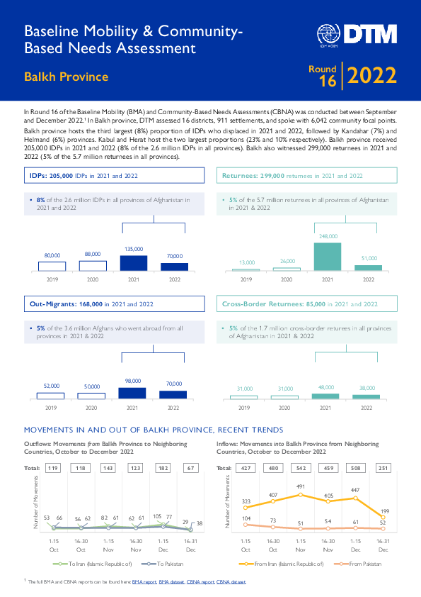
DTM has been conducting the Baseline Mobility Assessment (BMA) in Afghanistan since 2016 to track mobility, provide information on population estimates, locations and geographic distribution of displaced and returnee populations, reasons for displacement, places of origin and periods of displacement. The Community-Based Needs Assessment (CBNA) provides a comprehensive overview of the evolving vulnerabilities and multisectoral needs in communities hosting internally displaced persons (IDPs) and returnees from abroad.
Data is collected at the settlement level through focus group discussions with community focal points and direct observation. The figures presented in the report are estimates provided by community focal points.
This factsheet delves into the key findings in Balkh province using the latest results from Round 16 (Sep to Dec 2022) of the BMA and CBNA, focusing on the 2021-to-2022 period.
The full report can be found here: Baseline Mobility Assessment and Community-Based Needs Assessment.

Sep 17 2022
- Mobility Tracking
- Site Assessment
- Village Assessment
Between August and September 2022, the International Organization for Migration (IOM), through its Displacement Tracking Matrix (DTM) methodology, deployed the Site Assessment (SA) and Village Assessment Survey (VAS) tools to assess the mobility, needs and vulnerabilities of Internally Displaced Persons (IDPs) and returning IDPs across Ethiopia.
According to data collected, living conditions of IDPs in the assessed sites continue to be inadequate and unsafe. In most assessed sites, no HH was living in individual HH shelters (1,937 sites, or 88.05%). In addition, data also shows that access to emergency shelter kits is limited and that needs related to shelter are acute. In line with these findings, in 62.16% of villages, the majority of returning IDPs had not received any Non-Food Item (NFI) upon return, showing a poor situation both in the sites of displacement and villages of return.

DTM Global Survey 2023
The Displacement Tracking Matrix (DTM) Global Survey 2023 is an annual stocktaking exercise which aims to present IOM DTM's operations and activities transparently. The Global Survey focuses on operations active from January 1 to December 31, 2023, with data collection occurring from February to April 2024.