Dashboard/Fact Sheet
Dec 18 2023
- Mobility Tracking
- Baseline Assessment
Depuis 2014 le Niger est touché par de multiples crises sécuritaires ainsi que des catastrophes récurrents qui ont causé le déplacement de
centaines de milliers de personnes à l’intérieur du pays. Diffa, Maradi, Tahoua et Tillaberi sont les régions les plus touchées par ces phénomènes
(insécurité et catastrophe). Jusqu’en 2024, les attaques des groupes armés ont continué à pousser les populations à fuir leurs localités pour trouver
refuge dans des zones plus stables. À cela s’ajoutent aussi les catastrophes (inondations, pluies torrentielles, etc.) qui touchent les populations
chaque année.
L’Organisation internationale pour les migrations (OIM) au Niger a mis en oeuvre la Matrice de suivi des déplacements (Displacement Tracking
Matrix, DTM en anglais) en 2016 en étroite collaboration avec le gouvernement du Niger pour collecter et diffuser des informations régulièrement
sur la population mobile afin d’offrir au gouvernement et aux partenaires humanitaires une meilleure compréhension des mouvements de
populations et des besoins changeants sur les lieux de déplacement ou de transit au Niger. L’outil DTM comporte quatre (4) composantes: le
suivi des mouvements de population, le suivi des flux migratoires, les enregistrements et les enquêtes. Pour apporter son appui au gouvernement
et aux partenaires humanitaires afin de mieux comprendre les tendances de déplacement et la situation des déplacés, l’OIM en collaboration
avec le Ministère de l’Action Humanitaire et de la Gestion des Catastrophes (MAH/GC) a mis en oeuvre la composante suivi des mouvements
de population depuis 2019, appelée « Évaluation des Villages » (Village Assessment Survey (VAS), en anglais).
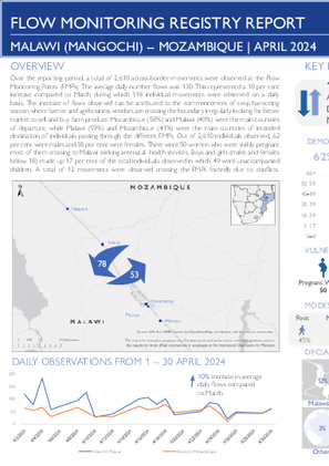
Apr 30 2024
- Flow Monitoring
This report is an overview of the data collected from 1 to 30 April 2024 at Mangochi FMP in Malawi along the border with Mozambique and Karonga FMP in Malawi along the border with the United Republic of Tanzania. The Flow Monitoring Registry (FMR) collects data at Flow Monitoring Points (FMPs) through direct observation and interviews with key informants, including staff working at transit stations, border patrol officers, local authorities, bus or taxi drivers and travellers themselves. The FMR gathers data on the number of travellers crossing FMPs, as well as the provenance, next destination, vulnerabilities and means of transport of travellers.
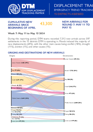
May 15 2024
- Mobility Tracking
- Baseline Assessment
This latest round of Emergency Trends Tracking was initiated in April 2024 to monitor displacements movements during the Gu rainy season. Districts covered in this round include Afgooye, Afmadow, Baardheere, Baidoa, Balcad, Belet Weyne, Gaalkacyo, Garoowe, Jamaame, Jowhar, Kismaayo, and Luuq.
ETT is a crisis-based tool that tracks sudden displacement triggered by specific events or emerging crises. The objective of ETT is to help prioritize humanitarian response and to enable partners to deliver rapid assistance. Based on previous shock induced displacement patterns, the humanitarian community expects that people will continue to move toward urban areas in search of humanitarian services. Consequently, the ETT coverage focuses on the main urban centers and surrounding villages for each assessed district. The data is collected through Key Informant Interviews (KIIs) at the location level, from Sunday to Wednesday every week. It includes information on new arrivals, numbers and demographic of IDPs, reasons for displacement, intentions, humanitarian assistance and priority needs among others.
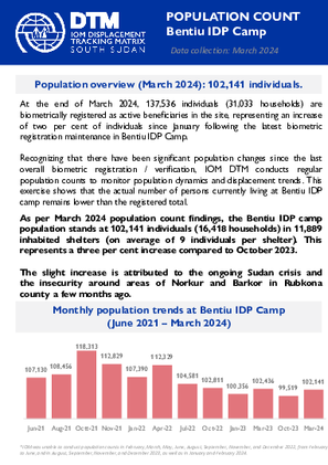
Mar 31 2024
- Registration
- Flow Monitoring
- Mobility Tracking
- Site Assessment
As per March 2024 population count findings, the Bentiu IDP camp population stands at 102,141 individuals (16,418 households) in 11,889 inhabited shelters (on average of 9 individuals per shelter). This represents a three per cent increase compared to October 2023.
Apr 19 2024
- Flow Monitoring
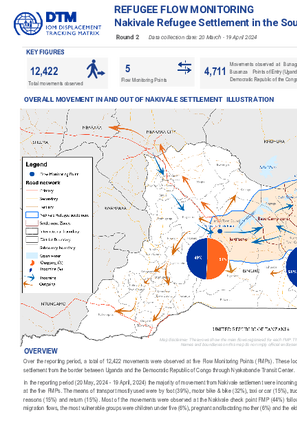
Over the reporting period, a total of 12,422 movements were observed at five Flow Monitoring Points (FMPs). These locations were chosen strategically as major transit points for monitoring movements in and out of Nakivale settlement from the border between Uganda and the Democratic Republic of Congo through Nyakabande Transit Center.
In the reporting period (20 May, 2024 - 19 April, 2024) the majority of movement from Nakivale settlement were incoming flows (52%) against outgoing flows (48%). Forty-four per cent of the observed movements were refugees at the five FMPs. The means of transport mostly used were by foot (39%), motor bike & bike (32%), taxi or car (15%), truck (8%), bus (3%) and others (2%). The majority of the flows were due to economic reasons (26%), family reasons (15%) and return (15%). Most of the movements were observed at the Nakivale check point FMP (44%) followed by Busanza (19%), Bunagana (19%), Rugaaga (11%) and Nyakabande transit centre (7%). Among migration flows, the most vulnerable groups were children under five (6%), pregnant and/lactating mother (6%) and the elderly (<1%).
May 15 2024
- Flow Monitoring
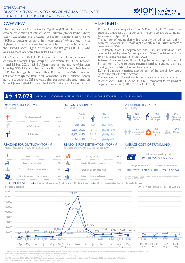
The International Organization for Migration (IOM) in Pakistan collects data on the outflows of Afghans at the Torkham (Khyber Pakhtunkhwa), Badini, Bahramcha and Chaman (Balochistan) border crossing points (BCPs) to better understand the movements of Afghans returning to Afghanistan. The data presented below is harmonised with those from the United Nations High Commissioner for Refugees (UNHCR), who also cover Ghulam Khan (Khyber Pakhtunkhwa).
On 26 September 2023, the Ministry of Interior in Pakistan announced its decision to enact its “Illegal Foreigners’ Repatriation Plan (IFRP)”. Between 1 and 15 May 2024, 16,348 Afghan nationals returned to Afghanistan, including 10,043 through the Torkham BCP, 5,909 through the Chaman BCP, 396 through the Ghulam Khan BCP, while no Afghan nationals returned through the Badini and Bahramcha BCPs. In addition, border authorities deported 725 individuals due to a lack of valid documentation. Since 1 January 2024, IOM identified 96,697 returns at the four BCPs.
May 18 2024
- Survey
- Flow Monitoring Survey
- Flow Monitoring
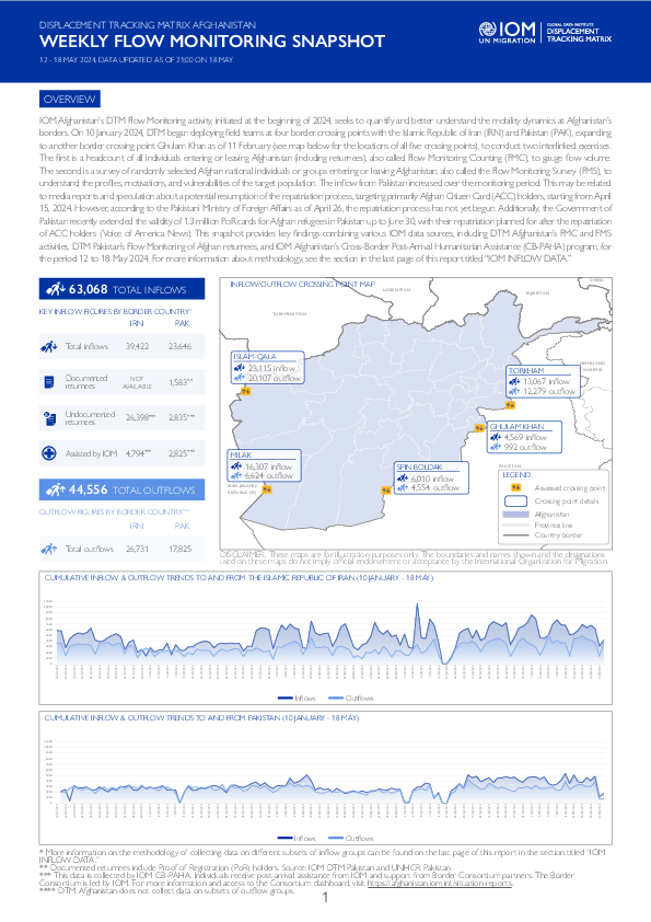
IOM Afghanistan's DTM Flow Monitoring activity, initiated at the beginning of 2024, seeks to quantify and better understand the mobility dynamics at Afghanistan’s borders. On 10 January 2024, DTM began deploying field teams at four border crossing points with the Islamic Republic of Iran (IRN) and Pakistan (PAK), expanding to another border crossing point Ghulam Khan as of 11 February (see map below for the locations of all five crossing points), to conduct two interlinked exercises. The first is a headcount of all individuals entering or leaving Afghanistan (including returnees), also called Flow Monitoring Counting (FMC), to gauge flow volume. The second is a survey of randomly selected Afghan national individuals or groups entering or leaving Afghanistan, also called the Flow Monitoring Survey (FMS), to understand the profiles, motivations, and vulnerabilities of the target population. The inflow from Pakistan increased over the monitoring period. This may be related to media reports and speculation about a potential resumption of the repatriation process, targeting primarily Afghan Citizen Card (ACC) holders, starting from April 15, 2024. However, according to the Pakistani Ministry of Foreign Affairs as of April 26, the repatriation process has not yet begun. Additionally, the Government of Pakistan recently extended the validity of 1.3 million PoR cards for Afghan refugees in Pakistan up to June 30, with their repatriation planned for after the repatriation of ACC holders (Voice of America News). This snapshot provides key findings combining various IOM data sources, including DTM Afghanistan’s FMC and FMS activities, DTM Pakistan’s Flow Monitoring of Afghan returnees, and IOM Afghanistan’s Cross-Border Post-Arrival Humanitarian Assistance (CB-PAHA) program, for the period 12 to 18 May 2024. For more information about methodology, see the section in the last page of this report titled “IOM INFLOW DATA.”
Apr 30 2024
- Other
Conflicts between farmers and herders in North-East Nigeria and other Sahel regions are rooted in many factors such as desertification, climate change impacts, low rainfall, and competition over suitable land for farming and transhumance activities. These issues are exacerbated by rapid population growth, which drives demand for food, shelter, and security for both humans and livestock. Consequently, competition for scarce natural resources intensifies, leading to incidents like farming on cattle routes, crop destruction, farm damage, and water pollution among others, which often escalate into violent confrontations between the farmer and herder communities.
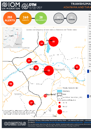
The Transhumance Tracking Tool (TTT) as a component of the IOM's Displacement Tracking Matrix (DTM), with the support of community key informants, operationalized the Early Warning System in the selected 9 Local Government Area (LGA) in the adjoining states of Adamawa and Taraba to collect alerts that are related to farmer-herder conflicts.
Of the 288 alerts recorded in April, 260 (90%) are event-related while 28 (10%) are related to movements. Specifically, Demsa, Girei, Lamurde, Numan and Shelleng LGAs in Adamawa state reported solely event-related alerts, while in Guyuk LGA, 89 per cent were event-related and 11 per cent were movement-related. Similarly, Mayo-belwa LGA reported 73 per cent event-related alerts and 27 per cent movement-related. Also in Taraba state, Lau LGA reported 74 per cent of event-related alerts and 26 per cent are movement-related alerts while Zing LGA reported 72 per cent of movement-related alerts and 28 per cent are event-related. Disaggregated ward-level data indicates that Kodompti, Talum and Demsa wards in Numan, Shelleng and Demsa LGAs of Adamawa state reported the highest percentage of events, cumulatively encompassing 20 per cent of the total alerts.
The event alerts reported across all LGAs suggested a population displacement rate of 2 per cent, with 17 per cent of instances of alerts resulting in casualties or injuries.
Apr 30 2024
- Mobility Tracking
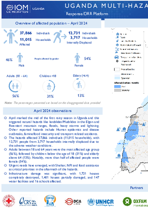
- April marked the mid of the first rainy season in Uganda and this triggered natural hazards like landslides/Mudslides in the Elgon and Rwenzori mountain ranges, floods, heavy storms and lightning. Other reported hazards include Human epidemics and disease outbreaks, famine/food insecurity and transport related accidents.
- The hazards affected 37,866 individuals (11,015 households), with 12,731 people from 3,717 households internally displaced due to the adverse weather conditions.
- Adults between 18 and 64 years were the most affected age group (56%), followed by children below the age of 18 (31%) and elderly above 64 (13%). Notably, more than half of affected people were female (54%).
- Urgent needs have emerged, with Shelter, NFI and food assistance as critical priorities in the aftermath of the hazards.
- Infrastructure damage was significant, with 1,721 houses completely destroyed, 1,401 houses partially damaged, and 147
water facilities and 16 schools affected.
May 11 2024
- Mobility Tracking
- Event Tracking
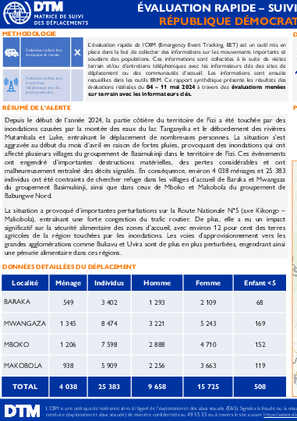
Depuis le début de l’année 2024, la partie côtière du territoire de Fizi a été touchée par des inondations causées par la montée des eaux du lac Tanganyika et le débordement des rivières Mutambala et Luke, entraînant le déplacement de nombreuses personnes. La situation s’est aggravée au début du mois d’avril en raison de fortes pluies, provoquant des inondations qui ont affecté plusieurs villages du groupement de Basimukinji dans le territoire de Fizi. Ces événements ont engendré d’importantes destructions matérielles, des pertes considérables et ont malheureusement entraîné des décès signalés. En conséquence, environ 4 038 ménages et 25 383 individus ont été contraints de chercher refuge dans les villages d’accueil de Baraka et Mwangaza du groupement Basimukinji, ainsi que dans ceux de Mboko et Makobola du groupement de Babungwe Nord.
La situation a provoqué d’importantes perturbations sur la Route Nationale N°5 (axe Kikongo – Makobola), entraînant une forte congestion du trafic routier. De plus, elle a eu un impact significatif sur la sécurité alimentaire des zones d’accueil, avec environ 12 pour cent des terres agricoles de la région touchées par les inondations. Les voies d’approvisionnement vers les grandes agglomérations comme Bukavu et Uvira sont de plus en plus perturbées, engendrant ainsi une pénurie alimentaire dans ces régions.

DTM API
Making global IDPs data accessible and reliable
The Displacement Tracking Matrix application programming interface (API) accelerates secure sharing of IDPs’ data, simplifying access to data across users and partners to support action, insight and foresight.