-
Countries
-
Data and Analysis
-
Special Focus
-
Crisis Responses
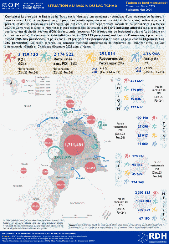
La crise dans le Bassin du lac Tchad est le résultat d’une combinaison complexe d’une multitude de facteurs, y compris un conflit armé impliquant des groupes armés non-étatiques, des niveaux extrêmes de pauvreté, un développement peinant, et des bouleversements climatiques, qui ont conduit à des déplacements importants de populations. En février 2024, le Cameroun, le Chad, le Niger et le Nigéria accueillaient un total de 6 031 612 individus affectés par la crise, dont des personnes déplacées internes (PDI), des retournés (anciennes PDI et retournés de l’étranger) et des réfugiés (vivant en et hors des camps). Treize pour cent des individus affectés (775 239 personnes) résidaient au Cameroun, 5 pour cent au Tchad (286 865 personnes), 9 pour cent au Niger (513 149 personnes) et enfin, 74 pour cent au Nigéria (4 456 360 personnes). De façon générale, les nombres montrent augmentation de retournés de l’étranger (+4%) et une diminution de réfugiés (-10%) depuis décembre 2023 dans la région.
Contact
DTM Uganda, dtmuganda@iom.int
Language
English
Location
Uganda
Period Covered
Jan 01 2024
Jan 31 2024
Activity
- Mobility Tracking
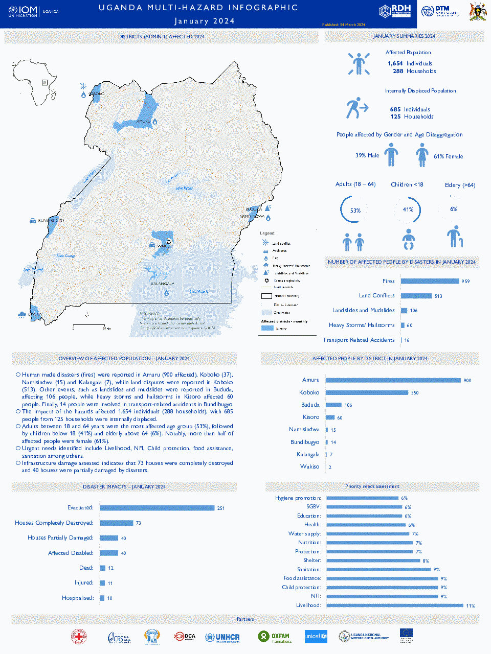
Human made disasters (fires), land disputes and extreme weather events such as landslides, mudslides as well as heavy storms and hailstorms have led to significant devastation in the districts of Amuru, Koboko, Bududa, Kisoro, Namisindwa, Bundibugyo, Kalangala and Wakiso. In January 2024, the disasters have adversely impacted 1,654 individuals, comprising 288 households, with 685 individuals from 125 households being internally displaced.
Demographically, adults (18-64 years) constitute the majority of the affected population at 53%, followed by children under 18 years at 41%, and the elderly above 64 years at 6%.
Infrastructure damage assessed indicates that 73 houses were completely destroyed and 40 houses were partially damaged by disasters.
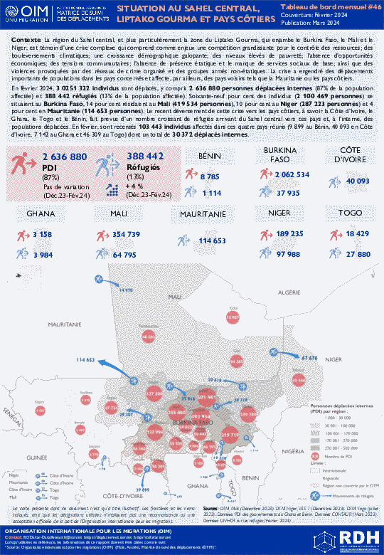
The Central Sahel area, and in particular the Liptako Gourma region, which borders Burkina Faso, Mali and Niger, is affected by a complex crisis involving growing competition over dwindling resources; climatic variability; demographic pressure; high levels of poverty; disaffection and a lack of livelihood opportunities; communal tensions; the absence of state institutions and basic services; and violence related to organized crime and non-state armed groups. The crisis has triggered significant displacement of populations in the concerned countries and is affecting neighbouring countries such as Mauritania and the coastal countries.
As of February 2024, 3,025,322 individuals have been displaced, including 2,636,880 internally displaced persons (87% of the displaced population) and 388,442 refugees (13% of the displaced population). Sixty-nine per cent of the displaced populations (2,100,469 individuals) were located in Burkina Faso, while 14 per cent resided in Mali (419,534 individuals), 10 per cent in Niger (287,223 individuals) and 4 per cent in Mauritania (114,653 individuals). The crisis’ recent spill over to coastal countries, namely Côte d’Ivoire, Ghana, Togo and Benin, shows growing number of refugees coming from the Central Sahel and populations internally displaced. As of February, 103,443 individuals were affected by displacement within the four countries (9,899 in Benin, 40,093 in Côte d’Ivoire, 7,142 in Ghana and 46,309 in Togo) of which 30,372 were internally displaced.
La région du Sahel central, et plus particulièrement la zone du Liptako Gourma, qui enjambe le Burkina Faso, le Mali et le Niger, est témoin d’une crise complexe qui comprend comme enjeux une compétition grandissante pour le contrôle des ressources; des bouleversements climatiques; une croissance démographique galopante; des niveaux élevés de pauvreté; l’absence d’opportunités économiques; des tensions communautaires; l’absence de présence étatique et le manque de services sociaux de base; ainsi que des violences provoquées par des réseaux de crime organisé et des groupes armés non-étatiques. La crise a engendré des déplacements importants de populations dans les pays concernés et affecte, par ailleurs, des pays voisins tels que la Mauritanie ou les pays côtiers.
En février 2024, 3 0251 322 individus sont déplacés, y compris 2 636 880 personnes déplacées internes (87% de la population affectée) et 388 442 réfugiés (13% de la population affectée). Soixante-neuf pour cent des individus (2 100 469 personnes) se situaient au Burkina Faso, 14 pour cent résidaient au Mali (419 534 personnes), 10 pour cent au Niger (287 223 personnes) et 4 pour cent en Mauritanie (114 653 personnes). Le recent déversement de cette crise vers les pays côtiers, à savoir la Côte d’Ivoire, le Ghana, le Togo et le Bénin, fait prevue d’un nombre croissant de réfugiés arrivant du Sahel central vers ces pays et, à l’interne, des populations déplacées. En février, sont recensés 103 443 individus affectés dans ces quatre pays réunis (9 899 au Bénin, 40 093 en Côte d’Ivoire, 7 142 au Ghana et 46 309 au Togo) dont un total de 30 372 déplacés internes.
Contact
dtmlebanon@iom.int
Language
English
Location
Lebanon
Period Covered
Oct 10 2023
Mar 14 2024
Activity
- Mobility Tracking
- Baseline Assessment
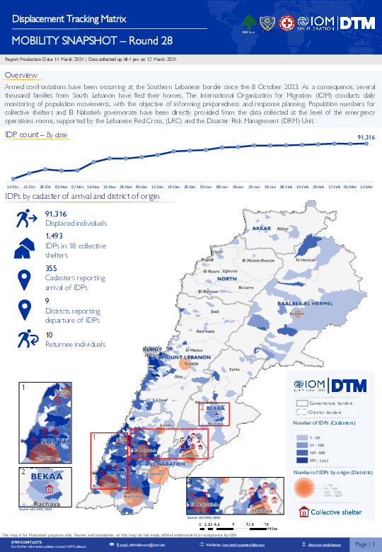
Since October 8 there has been an increase in cross-border incidents between Israel and Lebanon, resulting in the displacement of people both within the South and elsewhere within the country. Since October 10, the Displacement Tracking Matrix (DTM) has been conducting the daily monitoring of population movements. The objective of the exercise is to inform preparedness and response planning.
Mar 14 2024
Print
Storm Daniel, also known as Cyclone Daniel, was the deadliest Mediterranean tropical-like cyclone in recorded history, as well as one of the costliest tropical cyclones on record outside of the north Atlantic Ocean. Forming as a low-pressure system around 4 September 2023, the storm affected Greece, Bulgaria, and Turkey with extensive flooding. The storm then organized as a Mediterranean low and was designated as Storm Daniel. It soon acquired quasi-tropical characteristics and moved toward the coast of Libya, where it caused catastrophic flooding before degenerating into a remnant low. The storm was the result of an omega block; a high-pressure zone sandwiched between two zones of low pressure, with the isobars shaping like the Greek letter omega.
Countries in this response
- Active DTM operation
- Past DTM operation

Contact
DTMUkraine@iom.int
Language
English
Location
Ukraine
Snapshot Date
Mar 14 2024
Activity
- Survey
The General Population Survey is a highly representative assessment with 20,000 random respondents interviewed, providing population data and enabling an assessment of the geographic distribution of the war-affected populations across the country.
Over the course of March 2022 to January 2023, the IOM’s Data and Analytics successfully carried out 12 rounds of the General Population Survey. Initially conducted bi-monthly and later transitioning to a monthly frequency, the results were extrapolated at both national and macro-regional levels. As of May 2023, the survey methodology underwent adaptation to generate quarterly representative data at the oblast level, thus facilitating localized analysis.
Contact
dtmuganda@iom.int
Location
Uganda
Activity
- Event Tracking
Period Covered
Jan 06 2024 -Feb 01 2024
In January, the impacts of the hazards affected 1,654 individuals (288 households), with 685 people from 125 households were internally displaced.
A more detailed version of this dataset is available, to get access kindly click on the 'Request Access' button
Population Groups
IDPs
Residents
Survey Methodology
Unit of Analysis Or Observation
Admin Area 2
Admin Area 3
Admin Area 4
Community
Type of Survey or Assessment
Key Informant
Keywords
Geographical Scope Full Coverage
Administrative boundaries with available data
The current dataset covers the following administrative boundaries
Contact
dtmuganda@iom.int
Location
Uganda
Activity
- Event Tracking
Period Covered
Feb 01 2024 -Feb 29 2024
In February 2024, the impacts of the hazards affected 3,935 individuals (993 households), with 1,525 people from 271 households were internally displaced.
A more detailed version of this dataset is available, to get access kindly click on the 'Request Access' button
Population Groups
IDPs
Residents
Survey Methodology
Unit of Analysis Or Observation
Admin Area 2
Admin Area 3
Community
Type of Survey or Assessment
Key Informant
Keywords
Geographical Scope Full Coverage
Administrative boundaries with available data
The current dataset covers the following administrative boundaries
