Share

Download

Share

Map Type
Atlas Map
Published date
Wed, 12/01/2021 - 11:10
Activity

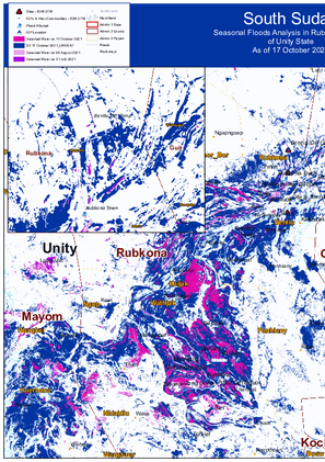
Seasonal Floods Analysis in Rubkona County of Unity State as of 17 October 2021.

Public Dataset

Share

Contact
SouthSudanDTM@iom.int
Location
South Sudan
Activity
  • Flow Monitoring Survey
  • Flow Monitoring
Period Covered
Aug 01 2021 -
Aug 31 2021
Flow monitoring aims to derive quantitative estimates of the flow of individuals through specific locations and to collect information about the profile, intentions and needs of the people moving and to quantify highly mobile populations by providing a picture of complex mobility dynamics.
Population Groups

Survey Methodology

Unit of Analysis Or Observation

Type of Survey or Assessment

Keywords

Geographical Scope

Administrative boundaries with available data

The current dataset covers the following administrative boundaries

Download

Share

Contact
DTMBurundi@iom.int
Language
French
Location
Burundi
Period Covered
Oct 01 2021
Oct 31 2021
Activity
  • Flow Monitoring Survey
  • Flow Monitoring

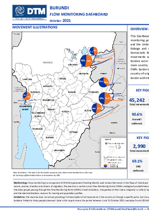
Ce tableau de bord fournit une analyse des tendances de la mobilité des populations observées au niveau de six (6) points de suivi des flux (Flow Monitoring Points, FMP), cinq (5) établis sur des points d’entrée non-officiels établis entre la frontière du Burundi et la République Unie de Tanzanie à Kwa Rutuku, Mukambati, Mbundi, Kabuyenge et Kabogo et un (1) point d’entrée officiel situé entre la frontière du Burundi et de la République Démocratique du Congo à Gatumba. Au cours de la période considérée, un total de 48 232 mouvements ont été observés à ces points. Environ 49,4 pour cent de tous les mouvements au niveau des deux frontières étaient sortants et 50,6 pour cent étaient entrants. La République Unie de Tanzanie était le principal pays d’origine (51,6%) et de destination (48,4%) de la plupart des mouvements suivis à travers les FMPs frontaliers avec ce pays. De même, la République Démocratique du Congo était le principal pays d’origine (35,6%) et de destination (64,4%) de la plupart des mouvements suivis à travers le FMP frontalier avec ce pays.

Download

Share

Contact
DTM Libya, DTMLibya@iom.int
Language
English
Location
Libya
Period Covered
Jun 01 2021
Sep 30 2021
Activity
  • Other

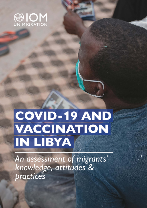
COVID-19 and Vaccination in Libya – An assessment of migrants’ knowledge, attitudes & practices report sheds light on what migrants know about COVID-19 pandemic, their beliefs and practices in relation to COVID-19 with an aim to inform risk communication and community engagement (RCCE) activities. This report also provides an overview of migrants’ perception and attitude towards COVID-19 vaccines, their willingness to get vaccinated and perceptions on potential barriers faced in accessing the vaccine.

Public Dataset

Share

Contact
SouthSudanDTM@iom.int
Location
South Sudan
Activity
  • Village Assessment
Period Covered
Mar 19 2021 -
Apr 22 2021
IOM’s Displacement Tracking Matrix (DTM) conducted the Village Assessment Survey (VAS) to facilitate planning for transition and recovery programs. Its main objectives are to map the availability of basic needs, services, infrastructure and to identify priority areas for intervention within selected counties in South Sudan. The assessment is funded by the Reconciliation, Stabilization and Resilience Trust Fund area based programming for Jonglei and Greater Pibor Administrative Area. Data collection and analysis was conducted as part of joint IOM and UNICEF-led program on strengthening education programs and infrastructure in targeted counties. Data was collected between March and April 2021, with previously inaccessible facilities and settlements in Akobo assessed in May and June 2021. DTM assessed the counties of Akobo and Pibor in Jonglei state, covering 25 bomas in seven payams (83.3% coverage) and 34 bomas in four payams (54.8% coverage), respectively. Five bomas in Akobo could not be assessed due to insecurity and road inaccessibility. In Pibor, five bomas could not be assessed due to road inaccessibility.
Population Groups

Survey Methodology

Unit of Analysis Or Observation

Type of Survey or Assessment

Keywords

Geographical Scope

Administrative boundaries with available data

The current dataset covers the following administrative boundaries

Download

Share

Contact
DTMBurundi@iom.int
Language
English
Location
Burundi
Period Covered
Oct 01 2021
Oct 31 2021
Activity
  • Flow Monitoring Survey
  • Flow Monitoring

This Dashboard provides an analysis of the trends in population mobility observed at six (6) flow monitoring points (FMPs), five (5) established at unofficial border crossing points between Burundi and the United Republic of Tanzania border at Kwa Rutuku, Mukambati, Mbundi, Kabuyenge and Kabogo and one (1) established at official border crossing point, between Burundi and the Democratic Republic of the Congo at Gatumba. Over the reporting period, a total of 48,232 movements were observed at these points. About 49.4 per cent of all movements at the two borders were outgoing and 50.6 per cent were incoming. The United Republic of Tanzania was the main country of origin (51.6%) and destination (48.4%) for the movements followed through the FMPs bordering this country. Similarly, the Democratic Republic of the Congo was also the main country of origin (35.6%) and destination (64.4%) for movements followed through the FMP at the border with the same country.

Public Dataset

Share

Contact
SouthSudanDTM@iom.int
Location
South Sudan
Activity
  • Village Assessment
Period Covered
Mar 19 2021 -
Apr 22 2021
IOM’s Displacement Tracking Matrix (DTM) conducted the Village Assessment Survey (VAS) to facilitate planning for transition and recovery programs. Its main objectives are to map the availability of basic needs, services, infrastructure and to identify priority areas for intervention within selected counties in South Sudan. The assessment is funded by the Reconciliation, Stabilization and Resilience Trust Fund area based programming for Jonglei and Greater Pibor Administrative Area. Data collection and analysis was conducted as part of joint IOM and UNICEF-led program on strengthening education programs and infrastructure in targeted counties. Data was collected between March and April 2021, with previously inaccessible facilities and settlements in Akobo assessed in May and June 2021. DTM assessed the counties of Akobo and Pibor in Jonglei state, covering 25 bomas in seven payams (83.3% coverage) and 34 bomas in four payams (54.8% coverage), respectively. Five bomas in Akobo could not be assessed due to insecurity and road inaccessibility. In Pibor, five bomas could not be assessed due to road inaccessibility.
Population Groups

Survey Methodology

Unit of Analysis Or Observation

Type of Survey or Assessment

Keywords

Geographical Scope

Administrative boundaries with available data

The current dataset covers the following administrative boundaries