- Mobility Tracking
- Baseline Assessment
May 05 2023
Population Groups
Survey Methodology
Unit of Analysis Or Observation
Type of Survey or Assessment
Keywords
Geographical Scope
Administrative boundaries with available data
The current dataset covers the following administrative boundaries
- Mobility Tracking
- Event Tracking
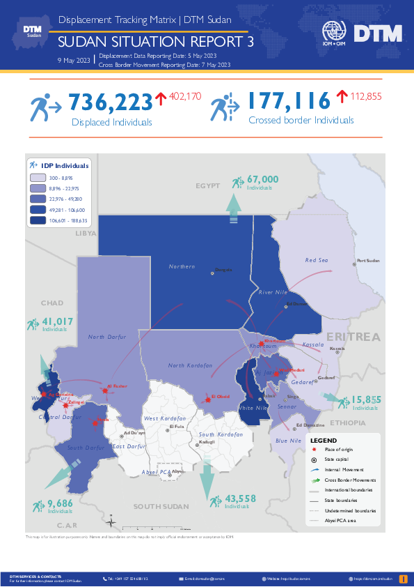
From 15 April 2023, armed clashes erupted between the Sudanese Army Forces (SAF) and the Rapid Support Forces (RSF) in multiple cities across Sudan, including Khartoum, Al Fasher, Merowe, Nyala, Ag Geneina, and El Obeid. DTM Sudan has been receiving reports of widespread displacement across different states in Sudan due to the ongoing security situation.
- Since 15 April 2023, DTM estimates that approximately 736,223 individuals (149,599 households) have been displaced internally as a result of the conflict.
- Notably, the current estimate for displacement since the conflict began is comparable to that recorded by DTM Sudan for all conflict-related displacement during 2021 and 2022 combined.
- Furthermore, an estimated 177,116 individuals have crossed into neighbouring countries.
Due to the ongoing nature of the fighting, many areas reportedly remain inaccessible to humanitarian actors. DTM estimates of displacement are based on preliminary reports from field teams and should be taken as estimations only. Additional reports of displacement are likely to emerge as the situation becomes clearer.
Locations of displacement have been reported in 15 of Sudan’s 18 states. Namely, these include the states of Khartoum, Northern, River Nile, Aj Jazirah, North Kordofan, White Nile, Sennar, Blue Nile, North Darfur, South Darfur, West Darfur, Central Darfur, Kassala, Gedaref, and Red Sea.
Disclaimer: Due to the current circumstances, the DTM network is relying on remote interviews with key informants and further verification is not possible at this time.
Oct 31 2022
- Survey
- Mobility Tracking
- Event Tracking
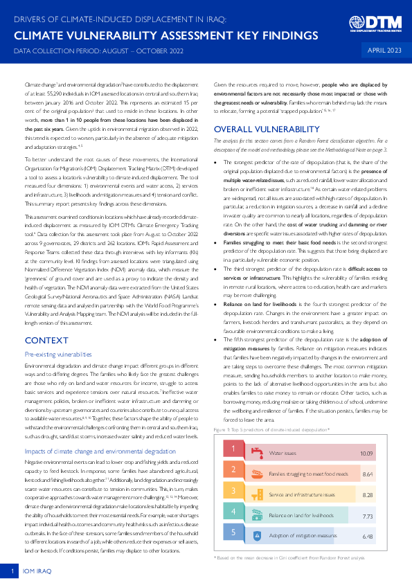
Climate change and environmental degradation have contributed to the displacement of at least 55,290 individuals in IOM assessed locations in central and southern Iraq between January 2016 and October 2022. This represents an estimated 15 per cent of the original population that used to reside in these locations. In other words, more than 1 in 10 people from these locations have been displaced in the past six years. Given the uptick in environmental migration observed in 2022, this trend is expected to worsen, particularly in the absence of adequate mitigation and adaptation strategies.
To better understand the root causes of these movements, the International Organization for Migration’s (IOM) Displacement Tracking Matrix (DTM) developed a tool to assess a location’s vulnerability to climate-induced displacement. The tool measured four dimensions: 1) environmental events and water access, 2) services and infrastructure, 3) livelihoods and mitigation measures and 4) tension and conflict. This summary report presents key findings across these dimensions.

This combined map provides information on Total Inflow (Arrival & Returned Migrants) at the provincial level during the period of 2012 - December 2021.

This combined map provides information on Returned Migrants from Abroad at the provincial level during the period of 2012 - December 2021.

This combined map provides information on Returned IDPs at the provincial level during the period of 2012 - December 2021.

This combined map provides information on Out Migrants at the provincial level during the period of 2012 - December 2021.
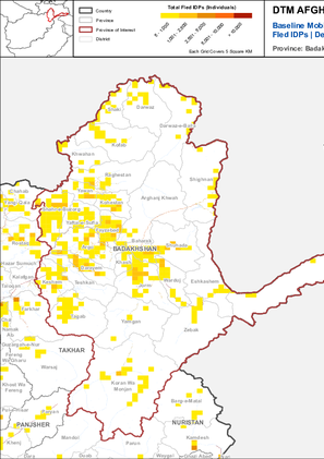
This combined map provides information on Fled IDPs at the provincial level during the period of 2012 - December 2021.
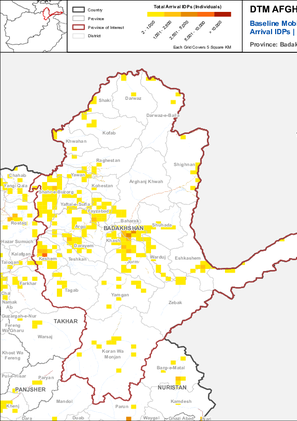
This combined map provides information on Arrival IDPs, on provincial level during the period of 2012 - December 2021.
- Mobility Tracking
- Site Assessment
Detention Centre Profiling is a component of IOM Libya’s Displacement Matrix programme. It is a data oriented tool that routinely provides specific sex and age demographic data and key sectorial information on individuals held in Libya’s detention centres on the date of assessment.

DTM API
Making global IDPs data accessible and reliable
The Displacement Tracking Matrix application programming interface (API) accelerates secure sharing of IDPs’ data, simplifying access to data across users and partners to support action, insight and foresight.