- Mobility Tracking
- Baseline Assessment
Sep 30 2022
Population Groups
Survey Methodology
Unit of Analysis Or Observation
Type of Survey or Assessment
Keywords
Geographical Scope
Administrative boundaries with available data
The current dataset covers the following administrative boundaries
- Mobility Tracking
- Baseline Assessment
Sep 30 2022
Population Groups
Survey Methodology
Unit of Analysis Or Observation
Type of Survey or Assessment
Keywords
Geographical Scope
Administrative boundaries with available data
The current dataset covers the following administrative boundaries

Oct 25 2022
- Mobility Tracking
- Event Tracking
Le suivi des situations d’urgence (en anglais, Emergency Tracking Tool, ETT) est une des composantes de la Matrice de suivi des déplacements (DTM) déployée par l’Organisation Internationale pour les Migrations (OIM). Il a pour objectif de rassembler des informations sur les mouvements significatifs et soudains de populations ainsi que sur des urgences sécuritaires et climatiques. Les données ont été collectées par observation directe et par des entretiens téléphoniques, auprès de 10 informateurs clés, principalement les autorités locales, les organisations de la société civile (OSCs) et les représentants des populations sinistrées dans les lieux affectés. Ce tableau de bord présente les informations sur les personnes affectées par la montée des eaux du fleuve Logone ayant provoqué des inondations et plusieurs dégâts matériels.
Durant la période du 21 au 24 octobre 2022, les localités de Gourlé et Molodia dans l’arrondissement du Goulfey, département du Logone et Chari, dans la région de l’Extrême-Nord du Cameroun ont été victimes de la montée des eaux (inondations) qui ont provoqué le déplacement de plusieurs centaines de personnes. Ce déplacement a contraint les populations à laisser derrière elles leurs bêtes et autres objets de valeurs en se dirigeant vers la localité de Angro et l'école publique de Molodia dans le même arrondissement.

Oct 23 2022
- Mobility Tracking
- Event Tracking
On 19 October, armed herders reportedly attacked the community Gbeji in the Ityuluv ward of Ukum LGA in Benue State. The attack affected 305 individuals and displaced 254 individuals to Ayiin Camp in Mbagber ward of Logo LGA in Benue State. As a result of the attack, 51 fatalities and 26 injuries were reported.
Also on 19 October, armed bandits reportedly attacked the community Unguwar Mata in Dangaladima ward of Anka LGA in Zamfara State. The attack affected 735 individuals and displaced 732 individuals to New Emir Palace IDP Camp in Magaji ward of Anka LGA. As a result of the attack 3 fatalities and 10 injuries were reported.
On 21 October, armed bandits reportedly attacked the community Kanwuri in Shinkafi North of Shinkafi LGA in Zamfara State. The attack affected 826 individuals and displaced 824 individuals to the community Galadima in Shinkafi South of Shinkafi LGA. As a result of the attack, 2 fatalities and 10 injuries were reported.

Reasons for Displacement per state Round 10 (October 2022)

Reasons for Displacement 2022 Round 10 (October 2022)
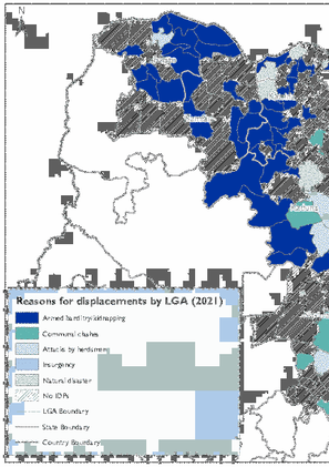
Reasons for Displacement 2021 Round 10 (October 2022)
IDPs per Year of Displacement Round 10 (October 2022)
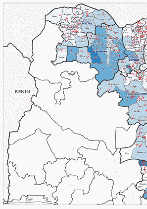
IDPs per LGA Round 10 (October 2022)

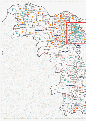
IDP Locations per State Round 10 (October 2022)

DTM API
Making global IDPs data accessible and reliable
The Displacement Tracking Matrix application programming interface (API) accelerates secure sharing of IDPs’ data, simplifying access to data across users and partners to support action, insight and foresight.