Share

Download

Share

Contact
DTM Sudan, DTMSudan@iom.int
Language
English
Location
Sudan
Snapshot Date
Sep 13 2023
Activity
  • Mobility Tracking
  • Baseline Assessment

Overview

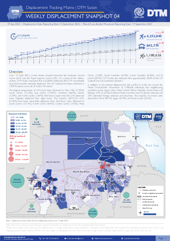
From 15 April 2023, armed clashes erupted between the Sudanese Armed Forces (SAF) and the Rapid Support Forces (RSF) in multiple cities across Sudan. Clashes initially took place in cities across Northern and Khartoum states, later spreading across the Darfur and Kordofan regions.

Highlights

  • DTM Sudan estimates that 4,232,840 Individuals (845,779 Households) have been recently internally displaced.
  • The IDP caseload has been observed in 3,929 locations across all of Sudan’s 18 states. 
  • The highest proportions of IDPs have been observed in River Nile (11.92%), South Darfur (11.53%), East Darfur (11.81%), Northern (8.64%), Sennar (7.59%), and North Darfur (7.69%).
  • Field teams report that the IDPs observed were originally displaced from eight states. The majority (2,875,125 IDPs (67.92%) have been reportedly displaced from Khartoum state; followed by South Darfur (15.11%), North Darfur (8.45%), Central Darfur (3.76%), West Darfur (3.70%), South Kordofan (0.59%), North Kordofan (0.46%), and Aj Jazirah (0.01%).
  • IOM DTM also reports that an estimated 1,180,626 mixed cross-border movements have been made into neighbouring countries.
Sep 19 2023 Print
Public Dataset

Share

Contact
Location
South Sudan
Activity
  • Event Tracking
Period Covered
Jan 01 2023 -
Dec 31 2023

IOM DTM employs Event Tracking as a more rapid and localized assessment tool complementing overall efforts to report IDP and Returnee figures nationally. IOM teams access IDP/Returnee locations and consult local key informants including community representatives, local authorities or humanitarian partners and triangulate findings to provide partners with the most accurate as possible, actionable and current data.

Population Groups

Survey Methodology

Unit of Analysis Or Observation

Type of Survey or Assessment

Keywords

Geographical Scope

Administrative boundaries with available data

The current dataset covers the following administrative boundaries

Download

Share

Map Type
Thematic Map
Published date
Tue, 09/19/2023 - 13:36
Activity
Mobility Tracking
Download

Share

Map Type
Thematic Map
Published date
Tue, 09/19/2023 - 13:33
Activity
Mobility Tracking
Download

Share

Map Type
Thematic Map
Published date
Tue, 09/19/2023 - 13:16
Activity
Mobility Tracking
Download

Share

Map Type
Thematic Map
Published date
Tue, 09/19/2023 - 13:13
Activity
Mobility Tracking
Download

Share

Map Type
Thematic Map
Published date
Tue, 09/19/2023 - 13:07
Activity
Mobility Tracking
Download

Share

Map Type
Thematic Map
Published date
Tue, 09/19/2023 - 13:04
Activity
Mobility Tracking