Map
Displaying 461 - 480 of 999
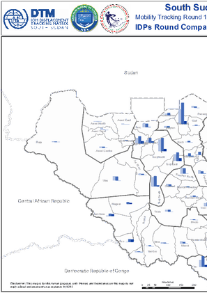
South Sudan - Mobility Tracking Round 11 - IDP Round Numbers Compared by County (September 2021)
This map compares the number of IDPs as assessed in different rounds of Mobility Tracking at the county level Mobility Tracking Round 11 September 2021
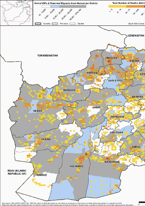
South Sudan - Mobility Tracking Round 11 - Arrivals of IDPs from Abroad at the County Level (September 2021)
This map displays the subset of IDPs who arrived at their counties in South Sudan from abroad by period of arrival Mobility Tracking Round 11 September 2021

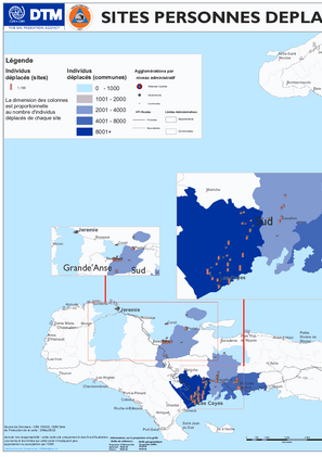
Haïti – Sites Personnes Déplacées Internes – Carte (Avril 2022)
Depuis juin 2021 une recrudescence dans les affrontements entre gangs armés a causé une situation dinsécurité généralisée dans plusieurs communes de la zone métropolitaine de PortauPrince et le déplacement de plus de 19 000 personnes Cette insécurité culminée par lassassinat du Président Jovenel Moïse en juillet 2021 aggrave la crise économique et politique qui continue daffecter Haiti Le 14 août…
Displacement Locations Maps - 14 August 2021 Earthquake (20 September 2021)
These maps show the location of displacement sites in the Southern departments of Haiti as of 20 September 2021 following the earthquake which struck on 14 August

DTM COVID-19 Regional Atlas Point Operational Status As Of 24 March 2022
The current outbreak of COVID19 has affected global mobility in complex and unprecedented ways in the form of various travel restrictions suspension of air travel and border closures To better understand this the International Organization for Migration IOM has developed a global mobility database to map these impacts on human mobility across global regional and country levels Furthermore COVID19…

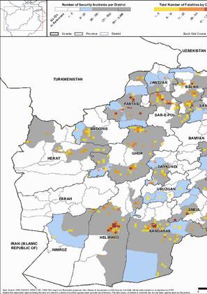
AFG_DTM_December2021_CBNA_Security_Incidents_and_Fatalities_in_Last_6_Months_Overview_By_District
This map provides information on total number of security incidents and fatalities in the last 6 months in villages assessed under Community Based Needs Assessment during the period from 2012 through December 2021
AFG_DTM_December2021_CBNA_Number_of_Deaths_in_Last_3_Months_Overview_By_District
This map provides information on total number of deaths in the last 3 months in villages assessed under Community Based Needs Assessment during the period from 2012 through December 2021
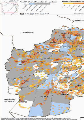
AFG_DTM_December2021_CBNA_Number_of_Unemployed_Adults_(18+)_Overview_By_District
This map provides information on number of unemployed adults 18 in villages assessed under Community Based Needs Assessment during the period from 2012 through December 2021
AFG_DTM_December2021_CBNA_No_Phone_&_No_Mobile_Network_Overview_By_District
This map provides information on individuals who do not have access to phone or mobile network in villages assessed under Community Based Needs Assessment during the period from 2012 through December 2021

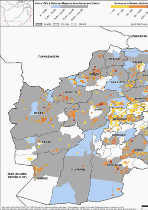
AFG_DTM_December2021_CBNA_No_Access_to_Markets_Overview_By_District
This map provides information on individuals who do not have access to markets in villages assessed under Community Based Needs Assessment during the period from 2012 through December 2021
AFG_DTM_December2021_CBNA_Individuals_Practicing_Open_Defection_Overview_By_District
This map provides information on individuals who do not have access to latrines in villages assessed under Community Based Needs Assessment during the period from 2012 through December 2021

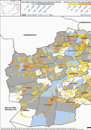
AFG_DTM_December2021_CBNA_No_Clinic_or_inaccessible _Overview_By_District
This map provides information on inaccessibility of clinics in villages assessed under Community Based Needs Assessment during the period from 2012 through December 2021
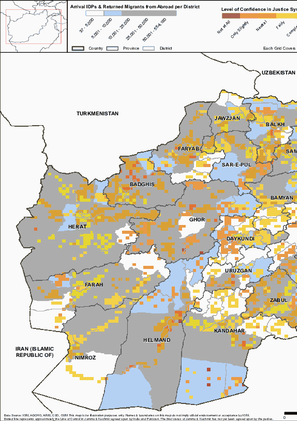
AFG_DTM_December2021_CBNA_Level_of_Confidence_in_Justice_System_Overview_By_District
This map provides information on level of confidence in justice system in villages assessed under Community Based Needs Assessment during the period from 2012 through December 2021
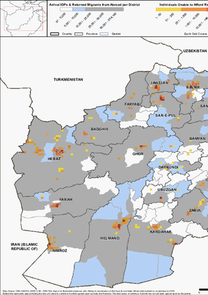
AFG_DTM_December2021_CBNA_Individual_Unable_to_Afford_Rent_Overview_By_District
This map provides information on individuals unable to afford rent in villages assessed under Community Based Needs Assessment during the period from 2012 through December 2021
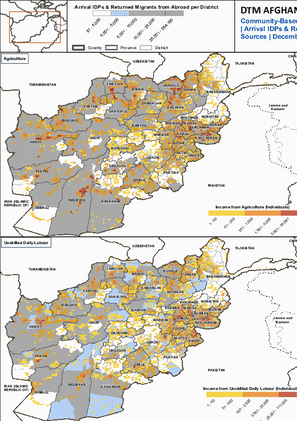
AFG_DTM_December2021_CBNA_Income_from_Unskilled_Daily_Labour_Overview_By_District
This map provides information on income from unskilled daily labour in villages assessed under Community Based Needs Assessment during the period from 2012 through December 2021

AFG_DTM_December2021_CBNA_Income_from_Unskilled_Daily_Labour_Overview_By_District
This map provides information on income from unskilled daily labour in villages assessed under Community Based Needs Assessment during the period from 2012 through December 2021

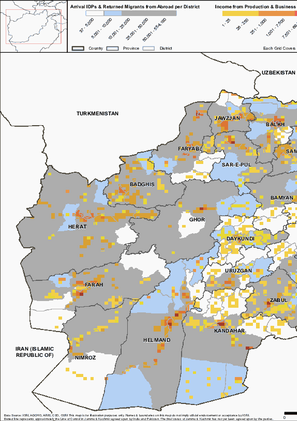
AFG_DTM_December2021_CBNA_Income_from_Production_Overview_By_District
This map provides information on income from production sources and businesses in villages assessed under Community Based Needs Assessment during the period from 2012 through December 2021
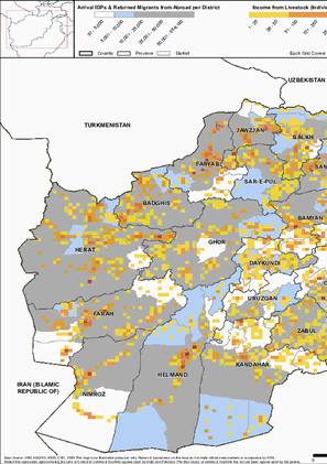
AFG_DTM_December2021_CBNA_Income_from_Livestock_Sources_Overview_By_District
This map provides information on income from livestock sources in villages assessed under Community Based Needs Assessment during the period from 2012 through December 2021
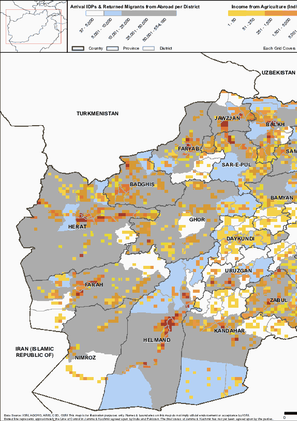
AFG_DTM_December2021_CBNA_Income_from_Agriculture_Sources_Overview_By_District&Villages
This map provides information on income from agriculture sources in villages assessed under Community Based Needs Assessment during the period from 2012 through December 2021
AFG_DTM_December2021_CBNA_Top 4_Income_Sources_Overview_By_District&Villages
This map provides information on Top 4 income sources of villages assessed under Community Based Needs Assessment during the period from 2012 through December 2021

DTM API
Making global IDPs data accessible and reliable
The Displacement Tracking Matrix application programming interface (API) accelerates secure sharing of IDPs’ data, simplifying access to data across users and partners to support action, insight and foresight.