Thematic Map
Focuses on a particular subject area
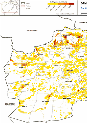
This map provides information on Out Migrants (Afghans who moved or fled abroad) During period of 2012 till December 2021.
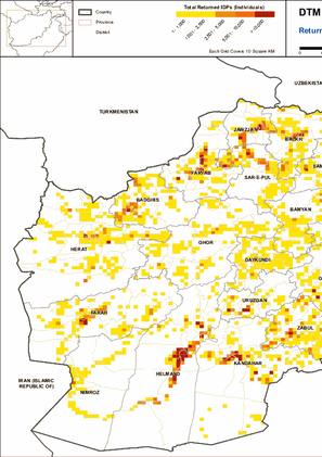
This map provides information on Returned IDPs (Afghans from an assessed village who had fled as IDPs in the past and have now returned home) During period of 2012 till December 2021.

This map provides information on Arrival IDPs (IDPs from other location currently residing in an assessed village) during period of 2012 till December 2021.
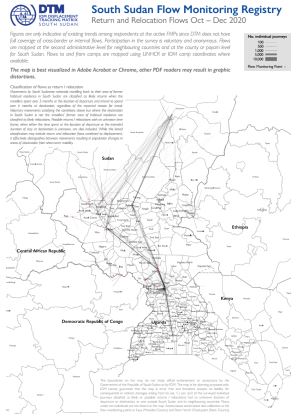
This map shows a picture of return and relocation flows tracked by DTM's Flow Monitoring Registry in South Sudan and between South Sudan and neighbouring countries, based on interviews carried out at 34 Flow Monitoring Points between October and December 2020. Figures are only indicative of existing trends among respondents at the active FMPs since DTM does not have full coverage of cross-border or internal flows. Participation in the survey is voluntary and anonymous.
Flows are mapped at the second administrative level for neighbouring countries and at the county or payam level for South Sudan. Flows to and from camps are mapped using UNHCR or IOM camp coordinates where available.
The map is best visualized in Adobe Acrobat or Chrome, other PDF readers may result in graphic distortions.

This map shows a picture of long / medium term migration flows tracked by DTM's Flow Monitoring Registry in South Sudan and between South Sudan and neighbouring countries, based on interviews carried out at 34 Flow Monitoring Points between October and December 2020. Figures are only indicative of existing trends among respondents at the active FMPs since DTM does not have full coverage of cross-border or internal flows. Participation in the survey is voluntary and anonymous.
Flows are mapped at the second administrative level for neighbouring countries and at the county or payam level for South Sudan. Flows to and from camps are mapped using UNHCR or IOM camp coordinates where available.
The map is best visualized in Adobe Acrobat or Chrome, other PDF readers may result in graphic distortions.
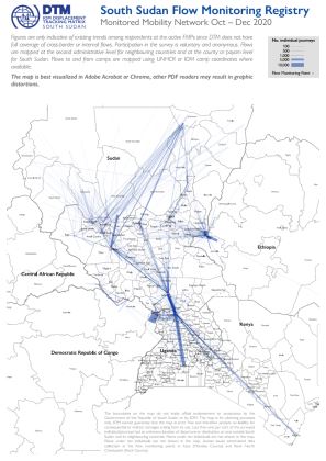
This map shows a picture of the human mobility network tracked by DTM's Flow Monitoring Registry in South Sudan and between South Sudan and neighbouring countries, based on interviews carried out at 34 Flow Monitoring Points between October and December 2020. Figures are only indicative of existing trends among respondents at the active FMPs since DTM does not have full coverage of cross-border or internal flows. Participation in the survey is voluntary and anonymous.
Flows are mapped at the second administrative level for neighbouring countries and at the county or payam level for South Sudan. Flows to and from camps are mapped using UNHCR or IOM camp coordinates where available.
The map is best visualized in Adobe Acrobat or Chrome, other PDF readers may result in graphic distortions.
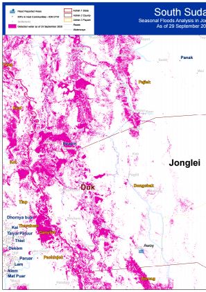
Seasonal Flood Analysis for Duk County in Jonglei State as of 29 September 2020.
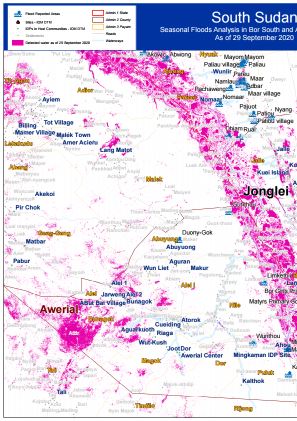
Seasonal Flood Analysis for Bor South County in Jonglei State and Awerial County in Lakes State as of 29 September 2020.

دا نقشه د ۲۰۱۲ کال څخه ۲۰۲۰ جون میاشتې اړوند ټولټال راغلیو کسانو په اړه ده (بهرنیو هېوادونو څخه راستنېدونکي + راغلي کورني بېځایه شوي).
دا نقشه د ۲۰۱۲ کال څخه ۲۰۲۰ جون میاشتې پورې اړوند بهرنیو هیوادونو څخه راستنېدونکو په اړه ده (هغه افغانان چې د ۶ میاشتو لپاره هېواد څخه بهر ته کډوال شوي ول او اوس بېرته افغانستان ته راستانه شوي دي).

DTM API
Making global IDPs data accessible and reliable
The Displacement Tracking Matrix application programming interface (API) accelerates secure sharing of IDPs’ data, simplifying access to data across users and partners to support action, insight and foresight.