Internal displacement
- Mobility Tracking
- Baseline Assessment
Dec 06 2023
A more detailed version of this dataset is available, to get access kindly click on the 'Request Access' button
Population Groups
IDPs
Migrants Present
Survey Methodology
Unit of Analysis Or Observation
Admin Area 2
Type of Survey or Assessment
Key Informant
Keywords
Geographical Scope Full Coverage
Administrative boundaries with available data
The current dataset covers the following administrative boundaries
- Mobility Tracking
- Event Tracking
Dec 09 2023
- Ma’rib (24 HHs) – Ma’rib City (19 HHs), Ma’rib (4 HHs), Raghwan (1 HHs) districts. Most displacements in the governorate originated from Ibb and Al Hodeidah.
- Al Hodeidah (8 HHs) – Al Khukhah (4 HHs), Hays (4 HHs) districts. All displacements in the governorate were internal.
- Ta’iz (8 HHs) – Al Makha (6 HHs), As Silw (2 HHs) districts. All displacements in the governorate were internal.
Population Groups
Survey Methodology
Unit of Analysis Or Observation
Type of Survey or Assessment
Keywords
Geographical Scope
Administrative boundaries with available data
The current dataset covers the following administrative boundaries
Dec 09 2023
- Mobility Tracking
- Event Tracking
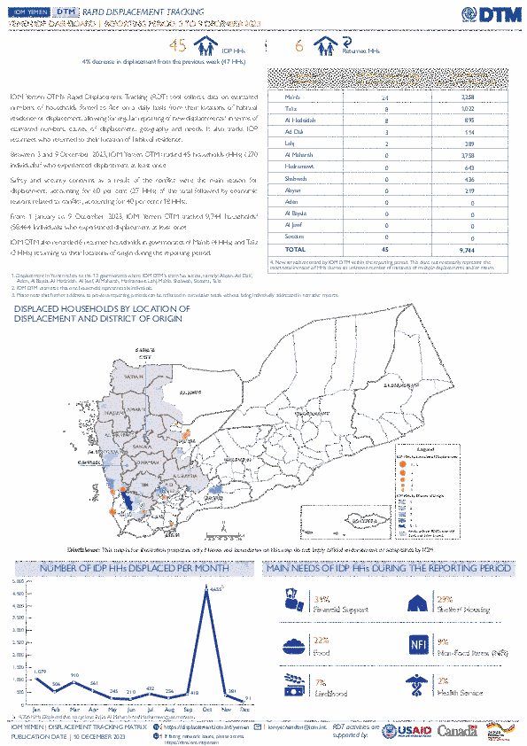
IOM Yemen DTM’s Rapid Displacement Tracking (RDT) tool collects data on estimated numbers of households forced to flee on a daily basis from their locations of origin or displacement, allowing for regular reporting of new displacements in terms of estimated numbers, geography, and needs. It also tracks returnees who returned to their location of origin.
From 1 January to 9 December 2023, IOM Yemen DTM tracked 9,744 households (HH) (58,464 Individuals) who experienced displacement at least once.
Between 3 and 9 December 2023, IOM Yemen DTM tracked 45 households (270 individuals) displaced at least once. The majority of people moved into/within the following governorates and districts:
- Ma’rib (24 HHs) – Ma’rib City (19 HHs), Ma’rib (4 HHs), Raghwan (1 HHs) districts. Most displacements in the governorate originated from Ibb and Al Hodeidah.
- Al Hodeidah (8 HHs) – Al Khukhah (4 HHs), Hays (4 HHs) districts. All displacements in the governorate were internal.
- Ta’iz (8 HHs) – Al Makha (6 HHs), As Silw (2 HHs) districts. All displacements in the governorate were internal.
The majority of people moved from the following governorates and districts:
- Al Hodeidah (14 HHs) – At Tuhayta (3 HHs), Jabal Ras (2 HHs), Al Marawiah (2 HHs) districts.
- Ta’iz (11 HHs) – Maqbanah (6 HHs), Al Mawasit (2 HHs), Sharab Ar Rawnah (1 HHs) districts.
Ibb (5 HHs) – Dhi As Sufal (2 HHs), An Nadirah (1 HHs), Hazm Al Odayn (1 HHs) districts.
Nov 18 2023
- Survey
- Site Assessment
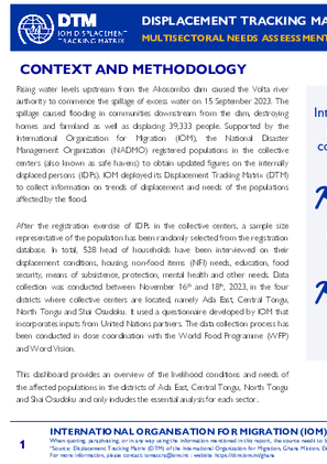
Rising water levels upstream from the Akosombo dam caused the Volta river authority to commence the spillage of excess water on 15 September 2023. The spillage caused flooding in communities downstream from the dam, destroying homes and farmland as well as displacing 39,333 people. Supported by the International Organization for Migration (IOM), the National Disaster Management Organization (NADMO) registered populations in the collective centers (also known as safe havens) to obtain updated figures on the internally displaced persons (IDPs). IOM deployed its Displacement Tracking Matrix (DTM) to collect information on trends of displacement and needs of the populations affected by the flood.
After the registration exercise of IDPs in the collective centers, a sample size representative of the population has been randomly selected from the registration database. In total, 528 head of households have been interviewed on their displacement conditions, housing, non-food items (NFI) needs, education, food security, means of subsistence, protection, mental health and other needs. Data collection was conducted between November 16th and 18th, 2023, in the four districts where collective centers are located, namely Ada East, Central Tongu, North Tongu and Shai Osudoku. It used a questionnaire developed by IOM that incorporates inputs from United Nations partners. The data collection process has been conducted in close coordination with the World Food Programme (WFP) and Word Vision.
This dashboard provides an overview of the livelihood conditions and needs of the affected populations in the districts of Ada East, Central Tongu, North Tongu and Shai Osudoku and only includes the essential analysis for each sector.
- Mobility Tracking
- Baseline Assessment
Nov 30 2023
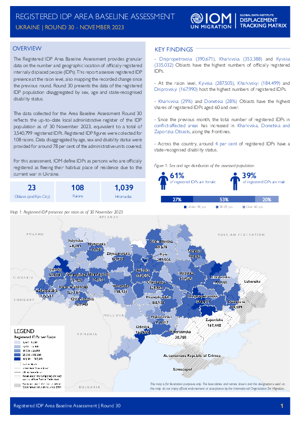
The data collected for the Area Baseline Assessment Round 30 reflects the up-to-date local administrative register of the IDP population as of 30 November 2023, equivalent to a total of 3,540,799 registered IDPs. Registered IDP figures were collected for 108 raions. Data disaggregated by age, sex and disability status were provided for around 78 per cent of the administrative units covered.
A more detailed version of this dataset at the Hromada level is available. To get access, kindly click on the 'Request Access' button.
Population Groups
IDPs
Survey Methodology
Unit of Analysis Or Observation
Admin Area 2
Type of Survey or Assessment
Key Informant
Keywords
Geographical Scope Full Coverage
Administrative boundaries with available data
The current dataset covers the following administrative boundaries
Dec 06 2023
- Mobility Tracking
- Baseline Assessment
Overview
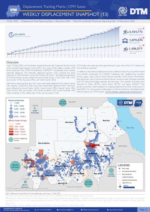
From 15 April 2023, armed clashes erupted between the Sudanese Armed Forces (SAF) and the Rapid Support Forces (RSF) in multiple cities across Sudan. Clashes initially took place in cities across Northern and Khartoum states, later spreading across the Darfur and Kordofan regions.
Dec 07 2023
- Mobility Tracking
- Event Tracking
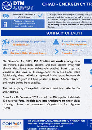
The objective of the Emergency Tracking Tool is to collect information on large and sudden population movements as well as on security and climate emergencies. Information is collected through key informant interviews or direct observation.
This dashboard presents information on a movement which occurred on 6 December 2023 in the town of Ounianga-Kébir, situated in the province of Ennedi Ouest, near the Libyan border.
Nov 30 2023
- Baseline Assessment
The Registered IDP Area Baseline Assessment provides granular data on the number and geographic location of officially registered internally displaced people (IDPs). This report assesses registered IDP presence at the raion level, also mapping the recorded change since the previous round. Round 30 presents the data of the registered IDP population disaggregated by sex, age and state-recognised disability status.
The data collected for the Area Baseline Assessment Round 30 reflects the up-to-date local administrative register of the IDP population as of 30 November 2023, equivalent to a total of 3,540,799 registered IDPs. Registered IDP figures were collected for 108 raions. Data disaggregated by age, sex and disability status were provided for around 78 per cent of the administrative units covered.
Dec 10 2023
- Mobility Tracking
- Event Tracking
Since 08 December 2023, armed clashes have broken out in the municipality of Tabarre, particularly in the nieghborhoods of HT Monquette, Truitier, Tapage and Dumornay. These clashes caused the displacement of approximately 317 households (1,240 individuals). These neighborhoods had suffered attacks in July 2023 (see ETT 20) and later experienced a relative lull inciting some people to return there. These people have therefore just been displaced again. Nearly half of these people (48%) took refuge in the site of Jean Marie Vincent which was created following the attacks of July 2023. This site had 923 people before the arrival of newly displaced people and now hosts 1,523 people with the latest arrivals.
- Mobility Tracking
- Baseline Assessment
Nov 29 2023
A more detailed version of this dataset is available, to get access kindly click on the 'Request Access' button
Population Groups
IDPs
Migrants Present
Survey Methodology
Unit of Analysis Or Observation
Admin Area 2
Type of Survey or Assessment
Key Informant
Keywords
Geographical Scope Full Coverage
Administrative boundaries with available data
The current dataset covers the following administrative boundaries

DTM API
Making global IDPs data accessible and reliable
The Displacement Tracking Matrix application programming interface (API) accelerates secure sharing of IDPs’ data, simplifying access to data across users and partners to support action, insight and foresight.