-
Countries
-
Data and Analysis
-
Special Focus
-
Crisis Responses
Internal displacement
Domain host
displacement.iom.int

Contact
abate@iom.int
Language
English
Location
Saint Vincent and the Grenadines
Period Covered
Jul 15 2024
Jul 16 2024
Activity
- Survey
- Return Intention
- Mobility Tracking
- Site Assessment
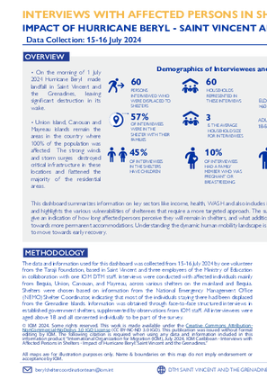
On1 July 2024, Hurricane Beryl struck Saint Vincent and the Grenadines, causing widespread devastation, particularly on Union Island, Canouan, and Mayreau, where the entire population was affected. This report provides an overview of the situation in shelters following the hurricane, highlighting key sectors such as income, health, WASH, and protection services.
Key Data Highlights:
-
48 out of 60 respondents (81%) were not able to return to their house and 11 respondents (19%) were returning home.
-
Among those returning home, 7 out of 11 (64%) were moving with family, one respondent was moving with some of their family members and the remaining 3 were moving alone.
-
Out of those 48 respondents unable to return home:
-
77% intend to stay in their shelters (All persons who intended to stay in the shelters also reported this was because their homes were destroyed)
-
13% intend to relocate
-
10% intend to move with family
-
This summary includes insights into the vulnerabilities of shelter residents and their movement intentions, providing crucial information as the response phase transitions to early recovery. The data, collected from 15-16 July 2024, involved structured interviews conducted in various government shelters.

Contact
abate@iom.int
Language
English
Location
Saint Vincent and the Grenadines
Period Covered
Jul 03 2024
Jul 05 2024
Activity
- Site Assessment
Hurricane Beryl made landfall in Grenada and Saint Vincent and the Grenadines on the morning of 1 July 2024, before passing along the southwest of Jamaica between 2 and 3 July 2024. Extreme winds and storm surges in Grenada and St. Vincent and the Grenadines prompted a national level 1 emergency response with collaboration from the Caribbean Disaster Emergency Management Agency (CDEMA). This report provides profiles on shelter and NFI-related needs in assessed locations in Saint Vincent and the Grenadines and Grenada. As this was a rapid assessment, not all shelters could be covered, so these profiles serve as a baseline for displaced persons' locations post-Hurricane Beryl. Given the fluid situation and ongoing relief efforts, this report offers a snapshot of needs at the time of data collection.

Contact
DTM DRC, iomdrcdtm@iom.int
Language
French
Location
Democratic Republic of the Congo
Period Covered
Apr 09 2024
May 20 2024
Activity
- Mobility Tracking
- Baseline Assessment
Ce tableau de bord présente les principaux résultats de suivi des mouvements de populations dans la province du Tanganyika à l’issue du onzième round d’évaluation conduit par l’unité de la Matrice de Suivi des Déplacements (Displacement Tracking Matrix, en anglais (DTM)) de l’Organisation Internationale pour les Migrations (OIM). Ces évaluations ont été réalisées à travers un exercice de collecte de données conduit du 9 avril au 20 mai 2024, en collaboration avec l’ONG locale, Promotion de Développement Humain et Protection de l’Environnement Social (PDHPES), et la Division Provinciale des Affaires Humanitaires (DIVAH). Lors de ce cycle, un total de 5 027 villages, couvrant 11 zones de santé (ZS), ont été évalués à travers des consultations avec 14 261 informateurs clé.

Contact
DTM DRC, iomdrcdtm@iom.int
Language
English
Location
Democratic Republic of the Congo
Period Covered
Jul 04 2024
Jul 25 2024
Activity
- Mobility Tracking
- Event Tracking
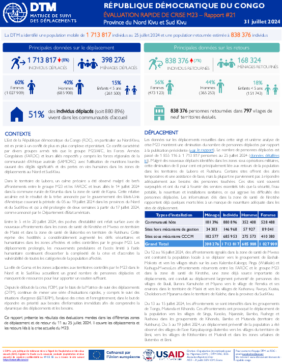
The east of the Democratic Republic of Congo (DRC), in particular North Kivu province, is in the grip of an increasingly complex and persistent conflict. This conflict is characterized by various armed groups such as the M23/AFC group, the congolese armed forces Forces Armées Congolaises (FARDC) and their respective allies including the Southern African Development Community Mission in the DRC (SAMIDRC), with the use of heavy munitions causing significant damage and loss of life in displacement areas of North and South Kivu.
In Lubero territory, a precarious calm was observed despite brief clashes between the M23 group and the FARDC and their allies on July 14, 2024 in the rural commune of Kirumba in the Kayna health zone. This relative lull is the result of the humanitarian truce announced by the government of the United States of America covering the period from July 5 to July 19, 2024 in the provinces of North and South Kivu, and which was extended by two weeks from July 17, 2024, as announced by the US State Department.
Between July 5 and July 20, 2024, pockets of instability resurfaced with new clashes in the Kirotshe and Mweso health zones in Masisi territory and in the Bukombo health zone in Rutshuru territory. This resumption of hostilities has considerably increased the security and humanitarian challenges in the affected areas and those controlled by the M23 group.
Prolonged displacement, commuting and limited access to humanitarian aid continue to exacerbate the complexity of the crisis and increase the vulnerability of all categories of the affected population.
The city of Goma and areas adjacent to M23-controlled territories in North and South Kivu are home to large numbers of displaced people, and lack the resources to provide them with sufficient support.
Since the start of the crisis, IOM, through the Displacement Tracking Matrix (DTM), has continued to conduct a series of rapid assessments, including emergency event tracking (EET/ERM), crisis analysis and registration, with the aim of prioritizing immediate information needs in order to understand displacement dynamics and needs.
This report presents the results of assessments carried out in the various displacement and return areas from July 11 to July 25, 2024. It covers displacements and returns linked to the current M23 crisis.

Contact
DTM DRC, iomdrcdtm@iom.int
Language
French
Location
Democratic Republic of the Congo
Period Covered
Jul 04 2024
Jul 25 2024
Activity
- Mobility Tracking
- Event Tracking
L’Est de la République démocratique du Congo (RDC), en particulier au Nord-Kivu, est en proie à un conflit de plus en plus complexe et persistant. Ce conflit caractérisé par divers groupes armés tels que le groupe M23/AFC, les Forces Armées Congolaises (FARDC) et leurs alliés respectifs y compris les forces régionales de la communauté d’Afrique australe (SAMIDRC) avec l'utilisation de munitions lourdes causant des dégâts significatifs et des pertes en vies humaines dans les zones de déplacements au Nord et Sud-Kivu.
Dans le territoire de Lubero, un calme précaire a été observé malgré de brefs affrontements entre le groupe M23 et les FARDC et leurs alliés le 14 juillet 2024 dans la commune rurale de Kirumba dans la zone de santé de Kayna. Cette relative accalmie est le résultat de la trêve annoncée par le gouvernement des Etats-Unis d'Amérique couvrant la période du 05 au 19 juillet 2024 dans les provinces du Nord et du Sud-Kivu et qui a été prolongée de deux semaines à partir du 17 juillet 2024, comme annoncé par le Département d'Etat américain.
Entre le 5 et le 20 juillet 2024, des poches d'instabilité ont refait surface avec de nouveaux affrontements dans les zones de santé de Kirotshe et Mweso en territoire de Masisi et dans la zone de santé de Bukombo en territoire de Rutshuru. Cette reprise des hostilités a considérablement augmenté les défis sécuritaires et humanitaires dans les zones affectées et celles contrôlées par le groupe M23. Les déplacements prolongés, les mouvements pendulaires et l'accès limité à l'aide humanitaire continuent d'exacerber la complexité de la crise et d'accroître la vulnérabilité de toutes les catégories de la population affectée.
La ville de Goma et les zones adjacentes aux territoires contrôlés par le M23 dans le Nord et le Sud-Kivu accueillent un grand nombre de personnes déplacées et manquent de ressources pour leur apporter un soutien suffisant.
Depuis le début de la crise, l'OIM, par le biais de la Matrice de suivi des déplacements (DTM), continue de mener une série d'évaluations rapides, y compris le suivi des situations d'urgence (EET/ERM), l'analyse des crises et l'enregistrement, dans le but de répondre en priorité aux besoins d'information immédiats afin de comprendre la dynamique des déplacements et les besoins.
Ce rapport présente les résultats des évaluations menées dans les différentes zones de déplacement et de retour du 11 au 25 juillet 2024. Il couvre les déplacements et les retours liés à la crise actuelle du M23.

Contact
iomkenyadru@iom.int
Language
English
Location
Kenya
Snapshot Date
Jul 30 2024
Activity
- Mobility Tracking
This report presents findings from the third round of Mobility Tracking. Mobility Tracking is a DTM methodology that aims to quantify the presence of population categories of interest, reasons for displacement, length of displacement and needs within defined geographical areas and locations, with a frequency that captures mobility dynamics.

Contact
DTM Somalia, IOMSomaliaDTM@iom.int
Language
English
Location
Somalia
Period Covered
Jul 20 2024
Jul 24 2024
Activity
- Mobility Tracking
- Baseline Assessment
This latest round of Emergency Trends Tracking was initiated in April 2024 to monitor displacements movements during the Gu rainy season. Districts covered in this round include Afgooye, Afmadow, Baardheere, Baidoa, Balcad, Belet Weyne, Belet Xaawo, Dayniile, Doolow, Gaalkacyo, Garoowe, Hodan, Jamaame, Jowhar, Kahda, Kismaayo, Luuq. ETT is a crisis-based tool that tracks sudden displacement triggered by specific events or emerging crises.
The objective of ETT is to help prioritize humanitarian response and to enable partners to deliver rapid assistance. Based on previous shock induced displacement patterns, the humanitarian community expects that people will continue to move toward urban areas in search of humanitarian services. Consequently, the ETT coverage focuses on the main urban centers and surrounding villages for each assessed district. The data is collected through Key Informant Interviews (KIIs) at the location level, from Sunday to Wednesday every week. It includes information on new arrivals, numbers and demographic of IDPs, reasons for displacement, intentions, humanitarian assistance and priority needs among others.
The ETT tool also adapts to regional contexts: because of the very high number of IDP sites in Khada and Daynile districts in Banadir region and in Baidoa district in Bay region, a zonal approach has been adopted for these areas. Each week, KIIs are first conducted at the zone level to indicate to the field teams which locations have received the most new arrivals and which need to be assessed.
To facilitate the joint analysis of the CCCM (Camp Coordination and Camp Management) Cluster’s New Arrivals Tracker (NAT) and ETT data, the assistance and needs indicators are identical in both tools.

Contact
iomnboim@iom.int
Language
English
Location
Kenya
Snapshot Date
Jul 30 2024
Activity
- Mobility Tracking
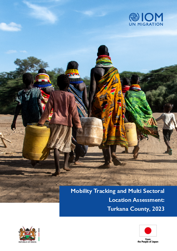
To assess drought-induced mobility and identify the most urgent sectoral needs experienced by the community, the IOM
Displacement Tracking Matrix (DTM) Mobility Tracking and Multi-Sectoral Location Assessment (MSLA) baseline assessment
was deployed in 2022 in Turkana County. A second round of data collection for mobility tracking took place between May
and June 2023, presented here. Key findings from this assessment included:
• Almost all arrival households (96% or 15,024 households) arrived at sub-locations in May 2023 that already
struggled with the severe effects of drought, resource-based conflict, and ethnic clashes.
• 78 per cent of returnees temporarily resided in Turkana in a location outside their immediate area of
origin, suggesting prevalent internal migration within the county.
• 19,515 child-headed households were identified. Of these, 1,622 (8%) had no relatives or community members
living near them and were separated from their legal or customary guardians.
• 6,216 children were without permanent sources of support.
• Almost half (48%) of the assessed sub-locations that reported loss of livestock reported child labour (whether
within or outside the ward) as a coping strategy, while around one quarter (24%) of sub-locations reported early
marriage of boys and girls as a key coping strategy.
Contact
DTM Ethiopia, DTMEthiopia@iom.int
Location
Ethiopia
Activity
- Mobility Tracking
- Village Assessment
Period Covered
Nov 23 2023 -Apr 28 2024
Between April and May 2024, IOM DTM deployed the SA round 36 and VAS round 19, in 11 regions across Ethiopia. The November - December 2023 data (Round 35 for SA and Round 18 for VAS) was compiled with the April - May 2024 data (Round 36 for SA and Round 19 for VAS) to consolidate national IDP and returning IDP figures updated to May 2024. The locations assessed during both rounds of data collection are not duplicated in the consolidated figures. SA is conducted in locations hosting a reported 20 or more IDP households, and the VAS is conducted in locations hosting a reported 20 or more returning IDP households that returned after 1 January 2022. It is to be noted that South Ethiopia region was not included due to operational constraints.
Population Groups
Returnee (Previously Internally Displaced)
Survey Methodology
Unit of Analysis Or Observation
Admin Area 2
Admin Area 3
Site or Location
Type of Survey or Assessment
Key Informant
Keywords
Geographical Scope Partial Coverage
Administrative boundaries with available data
The current dataset covers the following administrative boundaries
Contact
DTM Ethiopia, DTMEthiopia@iom.int
Location
Ethiopia
Activity
- Mobility Tracking
- Site Assessment
Period Covered
Nov 24 2023 -May 01 2024
Between April and May 2024, IOM DTM deployed the SA round 36 and VAS round 19, in 11 regions across Ethiopia. The November - December 2023 data (Round 35 for SA and Round 18 for VAS) was compiled with the April - May 2024 data (Round 36 for SA and Round 19 for VAS) to consolidate national IDP and returning IDP figures updated to May 2024. The locations assessed during both rounds of data collection are not duplicated in the consolidated figures. SA is conducted in locations hosting a reported 20 or more IDP households, and the VAS is conducted in locations hosting a reported 20 or more returning IDP households that returned after 1 January 2022. It is to be noted that South Ethiopia region was not included due to operational constraints.
Population Groups
IDPs
Survey Methodology
Unit of Analysis Or Observation
Admin Area 2
Admin Area 3
Site or Location
Type of Survey or Assessment
Key Informant
Keywords
Geographical Scope Partial Coverage
Administrative boundaries with available data
The current dataset covers the following administrative boundaries
Pagination
- Previous page
- Page 52
- Next page
