Mobility Tracking

Oct 30 2024
- Mobility Tracking
- Event Tracking
Since 20 October 2024, DTM monitored an escalation in clashes between the Sudanese Armed Forces (SAF) and Rapid Support Forces (RSF) across multiple localities in Aj Jazirah state. The Focused Flash Alert provides a numeric breakdown of displacement due the recent escalations in Aj Jazirah state from 20 to 30 October 2024.
All figures should be understood as preliminary estimates, pending further verification.
- Reported clashes displaced an estimated 135,405 individuals (27,081 households) between 20 and 30 October 2024.
- More than half (57%) of IDPs were displaced to localities in Gedaref state, including Al Butanah and Madeinat Al Gedaref localities.
- Among the individuals displaced, many were already displaced prior to the escalation and therefore experienced secondary displacement.
DTM Sudan releases Early Warning Flash Alerts to provide immediate updates on specific incidents or armed clashes that spurred displacement. Early Warning Flash Alerts are distributed via the DTM Sudan mailing list. For more granular information on displacement and mobility, see Sudan Mobility Update (10).

Jul 21 2024
- Mobility Tracking
- Event Tracking
Between 15 and 20 July 2024, a total of 1,648 new arrivals were recorded at locations in Benue State. The new arrivals were recorded in Agatu, Guma, Kwande, Markudi, Kwande, Logo and Ukum local government areas (LGAs) of Benue State.
- Mobility Tracking
- Baseline Assessment
Oct 27 2024
Since October 8 there has been an increase in cross-border incidents between Israel and Lebanon, resulting in the displacement of people both within the South and elsewhere within the country. Since October 10, the Displacement Tracking Matrix (DTM) has been conducting the daily monitoring of population movements. The objective of the exercise is to inform preparedness and response planning.
To get access kindly click on the 'Request Access' button. Please use your official work email, and specify the organisation name. Thank you.
Population Groups
IDPs
Survey Methodology
Unit of Analysis Or Observation
Admin Area 2
Admin Area 3
Type of Survey or Assessment
Key Informant
Keywords
Geographical Scope Full Coverage
Administrative boundaries with available data
The current dataset covers the following administrative boundaries
- Mobility Tracking
- Site Assessment
Mar 16 2024
In Round 47, a total of 2,271,987 Internally Displaced Persons (IDPs) were identified in 468,013 households. This signifies a slight decrease of one per cent (or 33,348 individuals) compared to Round 46 when 2,305,335 IDPs were recorded (December 2023). During Round 47, IDP assessments were conducted in 2,299 locations across the six states of north-east Nigeria. The assessed locations included 266 camps and camp-like settlements and 2,033 locations where internally displaced persons lived among host communities. Furthermore, 2,093,604 returnees were recorded in Borno, Adamawa and Yobe (BAY) states during the Round 47 assessment. This number represents an increase of 9,769 individuals or less than one per cent compared to Round 46 when 2,083,835 returnees were recorded in December 2023.
Population Groups
IDPs
Returnee (Previously Internally Displaced)
Survey Methodology
Unit of Analysis Or Observation
Admin Area 2
Site
Type of Survey or Assessment
Key Informant
Keywords
Geographical Scope Partial Coverage
Administrative boundaries with available data
The current dataset covers the following administrative boundaries
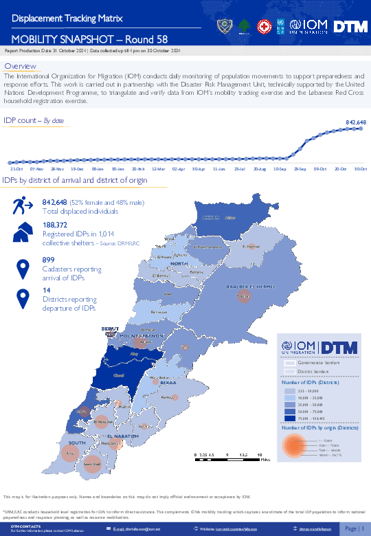
Oct 30 2024
- Mobility Tracking
- Baseline Assessment
Since October 8 there has been an increase in cross-border incidents between Israel and Lebanon, resulting in the displacement of people both within the South and elsewhere within the country. Since October 10, the Displacement Tracking Matrix (DTM) has been conducting the daily monitoring of population movements. The objective of the exercise is to inform preparedness and response planning.
- Mobility Tracking
- Baseline Assessment
Oct 22 2024
- An estimated total of 11,018,231 IDPs were displaced to 9,470 locations, in 184 localities, across all 18 states in Sudan.
- An estimated 8,268,984 individuals were displaced internally within Sudan since 15 April 2023.
- An estimated 28 per cent of IDPs who were initially displaced prior to the onset of the current conflict experienced secondary displacement since 15 April 2023.
- Approximately 3,128,939 individuals crossed borders into neighbouring countries since 15 April 2023.
- The top states of origin were Khartoum (33%), South Darfur (19%), and North Darfur (15%).
- The highest proportion of IDPs were hosted in South Darfur (17%), North Darfur (14%), and Gedaref (9%) states.
- Over half (53%) of IDPs were reportedly children under the age of 18-years-old.
A more detailed version of this dataset is available, to get access kindly click on the 'Request Access' button
Population Groups
IDPs
Survey Methodology
Unit of Analysis Or Observation
Admin Area 2
Type of Survey or Assessment
Key Informant
Keywords
Geographical Scope Full Coverage
Administrative boundaries with available data
The current dataset covers the following administrative boundaries

Sep 30 2024
- Flow Monitoring
- Flow Monitoring Registry
- Mobility Tracking
- Transhumance Tracking Tool
In September 2024, Transhumance Flow Monitoring tool identified 120 herders in Kaduna State and 182 herders in Katsina State. The animal count was estimated at 519 for Kaduna State and 1,328 for Katsina State. Notably, 85 per cent of the total number of herders departed from states within Nigeria, while the remaining 15 per cent departed from Niger.

Oct 23 2024
- Mobility Tracking
- Baseline Assessment
This latest round of Emergency Trends Tracking was initiated in April 2024 to monitor displacements movements during the Gu rainy season. From April to September 2024, DTM teams collected data in up to 22 districts: Afgooye, Afmadow, Baardheere, Baidoa, Balcad, Belet Weyne, Belet Xaawo, Cabudwaaq, Dayniile, Dhuusamarreeb, Doolow, Gaalkacyo, Garoowe, Hodan, Jamaame, Jowhar, Kahda, Kismaayo, Luuq, Waajid, Xudur and Hobyo. During weeks 28-30, data collection occurred in only 4 districts: Xudur, Waajid, Gaalkacyo and Hobyo districts.
The objective of ETT is to help prioritize humanitarian response and to enable partners to deliver rapid assistance. Based on previous shock induced displacement patterns, the humanitarian community expects that people will continue to move toward urban areas in search of humanitarian services. Consequently, the ETT coverage focuses on the main urban centers and surrounding villages for each assessed district. The data is collected through Key Informant Interviews (KIIs) at the location level, from Sunday to Wednesday every week. It includes information on new arrivals, numbers and demographic of IDPs, reasons for displacement, intentions, humanitarian assistance and priority needs among others.
To facilitate the joint analysis of the CCCM (Camp Coordination and Camp Management) Cluster’s New Arrivals Tracker (NAT) and ETT data, the assistance and needs indicators are identical in both tools.

Jun 30 2024
- Flow Monitoring
- Mobility Tracking
Ҳадафи ин гузориш пешниҳоди шарҳи намудҳои муҳоҷират ва ҳаракат дар Тоҷикистон бо истифода аз маълумотҳои охирини дастраси аз моҳи январ то моҳи июни соли 2024, ва аз маҷмӯаҳои маълумотҳои миллӣ ва байналмилалӣ оид ба ҳаракатҳои муҳоҷират бо тамаркуз ба вазъи охирини муҳоҷират дар Тоҷикистон мебошад. Ин гузориш додаҳо доир ба ҷараёнҳои муҳоҷират, шумораи иҷозатномаҳои истиқоматӣ, интиқоли маблағҳо ва инчунин сабабҳои муҳоҷиратро дар бар мегирад. Дар ин гузориш таъсири идомаи ҳамлаи кишвари Россия ба Украина ба долонҳои анъанавии муҳоҷиратӣ дар минтақа, тағйири ҷараёни муҳоҷирати меҳнатӣ, афзоиши сатҳи тағйирёбии иқлим ва нигарониҳои муҳоҷират, раванди афзояндаи шаҳрнишинӣ (урбанизатсия), вазъи иҷтимоиву иқтисодӣ ва дигар рӯйдодҳои муҳим, ҳамчун омилҳои асосии мусоидаткунанда ба ҳаракати одамон ва ҳаракатҳои муҳоҷират дар давраи мазкур дар кишвар тасвир шудаанд. Илова бар ин, гузориши мазкур ҳамчунин таъсири ҳодисаи фоҷеабори Крокус Сити Ҳолл, ки дар шаҳри Красногорск дар наздикии шаҳри Маскав, ки 22 марти соли 2024 аз ҷониби гурӯҳи Давлати Исломӣ-Хуросон (ДОИШ-К) ба вуқӯъ омада буд ва муҳоҷирони тоҷикро ба ҳайси омилони ҳаракатҳои муҳоҷират ҷалб намуда буд, дар бар мегирад.

Oct 22 2024
- Mobility Tracking
- Baseline Assessment
This report reflects data corresponding to Sudan Mobility Update (10) dataset. The dataset is available here.
Overview:
This report provides an overview of the total population of internally displaced persons (IDPs) in Sudan, including those displaced both before and after the onset of the conflict on 15 April 2023.
Key Findings:
- An estimated total of 11,018,231 IDPs were displaced to 9,470 locations, in 184 localities, across all 18 states in Sudan.
- An estimated 8,268,984 individuals were displaced internally within Sudan since 15 April 2023.
- An estimated 28 per cent of IDPs who were initially displaced prior to the onset of the current conflict experienced secondary displacement since 15 April 2023.
- Approximately 3,128,939 individuals crossed borders into neighbouring countries since 15 April 2023.
- The top states of origin were Khartoum (33%), South Darfur (19%), and North Darfur (15%).
- The highest proportion of IDPs were hosted in South Darfur (17%), North Darfur (14%), and Gedaref (9%) states.
- Over half (53%) of IDPs were reportedly children under the age of 18-years-old.
Annex 1 includes an operational matrix with a table of estimated IDPs per state, disaggregated by displacement before versus after 15 April 2023.
Note: The number of IDPs displaced post 15 April 2023 (8,268,984 IDPs) includes the estimated 1,071,525 IDPs who were initially displaced prior to 15 April 2023 and experienced secondary displacement since 15 April 2023. DTM Sudan defines an internally displaced person as any person who has been forced or obliged to flee from their habitual residence due to an event dating from 2003 onwards.

DTM Global Survey 2023
The Displacement Tracking Matrix (DTM) Global Survey 2023 is an annual stocktaking exercise which aims to present IOM DTM's operations and activities transparently. The Global Survey focuses on operations active from January 1 to December 31, 2023, with data collection occurring from February to April 2024.