Mobility Tracking
- Mobility Tracking
- Baseline Assessment
Oct 20 2024
Since October 8 there has been an increase in cross-border incidents between Israel and Lebanon, resulting in the displacement of people both within the South and elsewhere within the country. Since October 10, the Displacement Tracking Matrix (DTM) has been conducting the daily monitoring of population movements. The objective of the exercise is to inform preparedness and response planning.
To get access kindly click on the 'Request Access' button. Please use your official work email, specify the organisation name. Thank you.
Population Groups
IDPs
Survey Methodology
Unit of Analysis Or Observation
Admin Area 2
Admin Area 3
Household
Individual
Type of Survey or Assessment
Key Informant
Keywords
Geographical Scope Full Coverage
Administrative boundaries with available data
The current dataset covers the following administrative boundaries

Oct 23 2024
- Mobility Tracking
- Baseline Assessment
Since October 8 there has been an increase in cross-border incidents between Israel and Lebanon, resulting in the displacement of people both within the South and elsewhere within the country. Since October 10, the Displacement Tracking Matrix (DTM) has been conducting the daily monitoring of population movements. The objective of the exercise is to inform preparedness and response planning.

Aug 22 2024
- Mobility Tracking
- Baseline Assessment
Ce rapport présente une vue d'ensemble détaillée de la situation actuelle du déplacement au niveau du pays en République démocratique du Congo (RDC), collectée par la DTM RDC. Il contient une analyse des données déjà publiées par l'OIM en septembre 2024 et complète l'Aperçu du Déplacement Interne récemment publié.
Ce Rapport sur le Déplacement Interne combine des données provenant d'un Mobility Tracking (MT) ciblé dans les quatre provinces orientales du pays (mis en oeuvre entre juillet et août 2024) ainsi que d'un exercice séparé (déployé sous le nom de MT Light), couvrant les 22 provinces restantes, pour lesquelles les données ont été collectées entre juin et juillet 2024.
La RDC est confrontée à une situation complexe de déplacement interne avec un ensemble varié de facteurs et d’impacts. Dans les provinces de l’est du pays, les conflits armés et l’insécurité sont depuis longtemps les principaux facteurs des déplacements prolongés à grande échelle que connaît la région. En plus de la crise humanitaire à grande échelle dans l’est du pays, d’autres zones de la RDC ont connu des conflits, l’insécurité et des catastrophes naturelles. Une compréhension complète de la situation des déplacements dans l’ensemble de la RDC est vitale pour informer l’aide humanitaire à court terme, ainsi que pour engager un plus grand nombre d’acteurs impliqués dans la programmation à long terme.

Aug 22 2024
- Mobility Tracking
- Baseline Assessment
This report presents a detailed overview of the current country-level displacement situation in the Democratic Republic of the Congo (DRC), as collected by DTM DRC. It contains analysis of data already published by DTM in September 2024 and accompanies the recently published Internal Displacement Overview.
The Internal Displacement Report combines data from targeted Mobility Tracking (MT) in the country’s four eastern provinces (conducted between July and August 2024) as well as from a separate exercise (known as MT Light), covering the remaining 22 provinces, for which data was collected between June and July 2024.
The DRC has a complex internal displacement situation with a diverse set of drivers and impacts. In the country’s eastern provinces, armed conflict and insecurity have long been the primary drivers of the large-scale protracted displacement that the region experiences. On top of the large-scale humanitarian crisis in the east of the country, other regions of the DRC have experienced conflict, insecurity, and disasters such as floods and landslides.
A complete understanding of the displacement situation across the entire DRC is vital to inform both near-term humanitarian assistance, as well as engaging a wider array of stakeholders involved in long-term programming.

Sep 30 2024
- Mobility Tracking
- Event Tracking
In South Sudan, a multifaceted humanitarian crisis is currently unfolding, driven by a combination of factors including communal conflicts, land disputes, widespread insecurity, violence, natural disasters, and cross-border displacement. These elements have created a challenging environment for the population, exacerbating the already dire humanitarian situation. The ongoing instability has led to significant disruptions in livelihoods and access to basic services, leaving many communities vulnerable and in urgent need of assistance.
In the month of September 2024, Juba, Fangak, Fashoda, and Wau Counties witnessed the arrival of 7,481 returnees. All these individuals returned as a result of the ongoing crisis in Sudan. This movement highlights the impact of the ongoing Sudan conflict, forcing thousands to flee and seek safety. While returnees are hopeful about reintegrating into their communities, they might face significant challenges in rebuilding their lives.

Sep 30 2024
- Mobility Tracking
- Event Tracking
South Sudan is currently facing a complex humanitarian crisis characterized by extensive internal displacements. The underlying causes of these displacement dynamics are varied and include communal clashes, flooding, insecurity, violence, natural disasters, and cross-border movements.
In the month of September 2024, enumerators from the Displacement Tracking Matrix documented significant flood-induced displacements affecting 44,497 individuals. The majority of these displacements occurred in Northern Bahr el Ghazal where 14,455 individuals were displaced to Aweil East, 11,756 to Aweil West and 9,030 to Aweil North. Additionally, 11,930 individuals were displaced to Abyei Administrative Area, while Jonglei and Western Bahr el Ghazal saw 6,500 and 995 individuals displaced to Fangak and Jur River, respectively.
The effect of these displacements calls for urgent humanitarian intervention among the affected population. Those who have been displaced identified their most pressing requirements as being in dire need of food, health and shelter.
Oct 15 2024
- Mobility Tracking
- Event Tracking
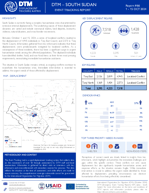
South Sudan is currently facing a complex humanitarian crisis characterized by extensive internal displacements. The underlying causes of these displacement dynamics are varied and include communal clashes, land disputes, insecurity, violence, natural disasters, and cross-border movements.
Between October 1 and 15, 2024, a series of localized conflicts resulted in the displacement of 4,945 individuals in Tonj East County and 2,573 in Tonj North County. Information gathered from key informants indicates that these displacements were predominantly instigated by localized conflicts. As a consequence of these incidents, there has been a significant surge in urgent humanitarian needs among the affected populations. The displaced individuals have identified shelter, food, and non-food items as their three most pressing requirements, necessitating immediate humanitarian assistance.
The situation in South Sudan remains critical, as ongoing conflicts continue to exacerbate the humanitarian crisis. Immediate intervention is essential to address the urgent needs of those affected by displacement.

Oct 15 2024
- Mobility Tracking
- Event Tracking
South Sudan is currently facing a complex humanitarian crisis characterized by extensive internal displacements. The underlying causes of these displacement dynamics are varied and include communal clashes, flooding, insecurity, violence, natural disasters, and cross-border movements.
Between 1st and 15th October 2024, enumerators from the Displacement Tracking Matrix documented significant disaster (flood) related displacements affecting 10,719 individuals. The majority of these displacements occurred in Northern Bahr el Ghazal where 7,775 individuals were displaced to Aweil West, 1,954 to Mayom County in Unity State, and 990 to Abyei Administrative Area.
The effect of these displacements calls for urgent humanitarian intervention among the affected population. Those who have been displaced identified their most pressing requirements as being in dire need of food, shelter, and non-food items.

Oct 23 2024
- Mobility Tracking
- Event Tracking
This report is an update of the one published on 20 October (ETT 51) following the armed attacks that have occurred since 17 October 2024 in the bordering areas of the municipalities of Port-au-Prince and Delmas on the one hand, particularly in the neighborhoods of Solino and Cité Numéro 2 and on the other hand in the municipality of Tabarre, precisely in the neighborhood of Tabarre 27. A total of 10,056 people were displaced following these attacks, including 8,361 due to the attacks in Port-au-Prince and Delmas and 1,695 due to those in Tabarre. The majority of people (55%), or 5,557 people, took refuge in 14 sites, including 10 that already existed before these incidents and 4 newly created following these incidents. The rest of the people (45%) took refuge with host families.

Oct 16 2024
- Mobility Tracking
- Baseline Assessment
This latest round of Emergency Trends Tracking was initiated in April 2024 to monitor displacements movements during the Gu rainy season. From April to September 2024, DTM teams collected data in up to 22 districts: Afgooye, Afmadow, Baardheere, Baidoa, Balcad, Belet Weyne, Belet Xaawo, Cabudwaaq, Dayniile, Dhuusamarreeb, Doolow, Gaalkacyo, Garoowe, Hodan, Jamaame, Jowhar, Kahda, Kismaayo, Luuq, Waajid, Xudur and Hobyo. During weeks 28 and 29, data collection occurred in only 4 districts: Xudur, Waajid, Gaalkacyo and Hobyo districts.
The objective of ETT is to help prioritize humanitarian response and to enable partners to deliver rapid assistance. Based on previous shock induced displacement patterns, the humanitarian community expects that people will continue to move toward urban areas in search of humanitarian services. Consequently, the ETT coverage focuses on the main urban centers and surrounding villages for each assessed district. The data is collected through Key Informant Interviews (KIIs) at the location level, from Sunday to Wednesday every week. It includes information on new arrivals, numbers and demographic of IDPs, reasons for displacement, intentions, humanitarian assistance and priority needs among others.
To facilitate the joint analysis of the CCCM (Camp Coordination and Camp Management) Cluster’s New Arrivals Tracker (NAT) and ETT data, the assistance and needs indicators are identical in both tools.

DTM Global Survey 2023
The Displacement Tracking Matrix (DTM) Global Survey 2023 is an annual stocktaking exercise which aims to present IOM DTM's operations and activities transparently. The Global Survey focuses on operations active from January 1 to December 31, 2023, with data collection occurring from February to April 2024.