-
Countries
-
Data and Analysis
-
Special Focus
-
Crisis Responses

Contact
DTM Nigeria, iomnigeriadtm@iom.int
Language
English
Location
Nigeria
Period Covered
Sep 04 2024
Sep 08 2024
Activity
- Mobility Tracking
- Event Tracking
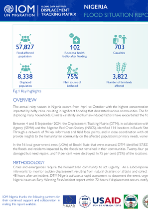
Between 4 and 8 September 2024, the Displacement Tracking Matrix (DTM), in collaboration with the National Emergency Management Agency (NEMA), the Bauchi State Emergency Management Agency (SEMA) and the Nigerian Red Cross Society (NRCS), identified 114 locations in Bauchi State that were impacted by floods or received internally displaced persons (IDPs) due to the flooding.
In the 16 local government areas (LGAs) of Bauchi State that were assessed, DTM identified 57,827 individuals in 9,620 households affected by the floods. These individuals included IDPs displaced by the floods and residents impacted by the floods but remained in their communities. Twenty-four per cent (24%) of the affected houses are habitable but need repair, repairs, 18 per cent were partially damaged but need repairs, and 19 per cent were destroyed. In 75 per cent (75%) of the locations assessed, crop farming was among the primary sources of income.

Contact
DTM Nigeria, iomnigeriadtm@iom.int
Language
English
Location
Nigeria
Period Covered
Sep 04 2024
Sep 08 2024
Activity
- Mobility Tracking
- Event Tracking
Between 4 and 8 September 2024, the Displacement Tracking Matrix (DTM), in collaboration with the National Emergency Management Agency (NEMA), the Niger State Emergency Management Agency (NSEMA), and the Nigerian Red Cross Society (NRCS), identified 71 locations in Niger State that were impacted by floods or received internally displaced persons (IDPs) due to the flooding.
In the eighteen (18) local government areas (LGAs) of Niger State that were assessed, DTM identified 16,559 individuals in 2,337 households affected by the floods. These individuals included IDPs displaced by the floods and residents impacted by the floods but remained in their communities. The affected population included 1,385 individuals and 272 displaced. Twenty-four per cent (24%) of the affected houses are habitable but need repair, sixteen per cent of the houses are partially damaged but need repairs and seven per cent are destroyed. In 86 per cent (86%) of the locations assessed, crop farming was among the primary sources of income.c

Contact
DTM Nigeria, iomnigeriadtm@iom.int
Language
English
Location
Nigeria
Period Covered
Sep 04 2024
Sep 08 2024
Activity
- Mobility Tracking
- Event Tracking
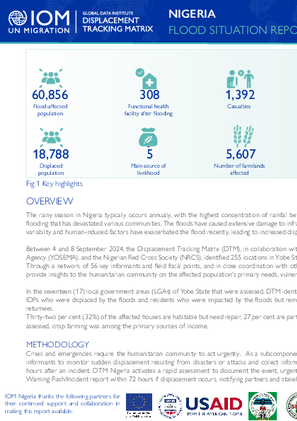
The rainy season in Nigeria typically occurs annually, with the highest concentration of rainfall between June and September. Many states have been impacted by hefty rains, resulting in significant flooding that has devastated various communities. The floods have caused extensive damage to infrastructure, crops, and shelters, severely affecting livelihoods and displacing many households. Climate variability and human-induced factors have exacerbated the flood recently, leading to increased displacement across Nigeria.
In the seventeen (17) local government areas (LGAs) of Yobe State that were assessed, DTM identified 60,856 individuals in 13,474 households affected by the floods. These individuals included both IDPs who were displaced by the floods and residents who were impacted by the floods but remained in their communities. The affected population included 18,788 displaced individuals and 567 returnees.
Thirty-two per cent (32%) of the affected houses are habitable but need repair, 27 per cent are partially damaged but need repairs, and 17 per cent are destroyed. In 75 per cent (75%) of the locations assessed, crop farming was among the primary sources of income.

Contact
DTM Nigeria, iomnigeriadtm@iom.int
Language
English
Location
Nigeria
Period Covered
Sep 04 2024
Sep 08 2024
Activity
- Mobility Tracking
- Event Tracking
The annual rainy season in Nigeria occurs from April to October with the highest concentration of rainfall. During July-August 2024, many states nationwide were impacted by hefty rains, resulting in significant flooding that devastated various communities. The floods caused extensive damage to infrastructure, crops, and shelters, severely affecting livelihoods and displacing many households. Climate variability and human-induced factors have exacerbated the flood recently, leading to increased displacement across Nigeria.
In the 20 local government areas (LGAs) of Jigawa State that were assessed, DTM identified 257,236 individuals in 42,603 households affected by the floods. These individuals included IDPs who were displaced by the floods and residents who were impacted by the floods but remained in their communities. The affected population included 94,893 displaced individuals.
Thirty-six per cent (36%) of the affected houses are habitable but need repair, forty-six per cent were partially damaged but need repairs, and 18 per cent were destroyed. In 96 per cent (96%) of the locations assessed, crop farming was among the primary sources of income.c

Contact
DTM Nigeria, iomnigeriadtm@iom.int
Language
English
Location
Nigeria
Period Covered
Sep 04 2024
Sep 12 2024
Activity
- Mobility Tracking
- Event Tracking
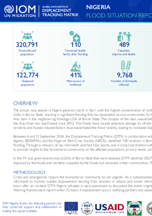
The annual rainy season in Nigeria generally starts in April, with the highest concentration of rainfall between June and September. Between August and September 2024, hefty rains affected many LGAs in Borno State, resulting in significant flooding that has devastated various communities. Furthermore, on 9 September 2024, Maiduguri was affected by a massive flood due to the collapse of Alau dam in the neighbouring Konduga LGA of Borno State. The collapse of the dam, exacerbated the flooding in Maiduguri in addition to the continuous heavy rainfall. This marks the first time the Alau Dam has overflowed since 2012. The floods have caused extensive damage to infrastructure, crops, and shelters, severely affecting livelihoods and displacing many households. Climate variability and human-induced factors have exacerbated the flood recently, leading to increased displacement across Nigeria.
In the 19 local government areas (LGAs) of Borno State that were assessed, DTM identified 320,791 individuals in 65,731 households affected by the floods. These individuals included IDPs displaced by the floods and residents impacted by the floods but remained in their communities. The affected population included 157,274 displaced individuals and 108 returnees.
Contact
dtmlebanon@iom.int
Location
Lebanon
Activity
- Mobility Tracking
- Baseline Assessment
Period Covered
Oct 10 2023 -Sep 03 2024
Since October 8 there has been an increase in cross-border incidents between Israel and Lebanon, resulting in the displacement of people both within the South and elsewhere within the country. Since October 10, the Displacement Tracking Matrix (DTM) has been conducting the daily monitoring of population movements. The objective of the exercise is to inform preparedness and response planning.
Aggregated data is available through the DTM API: https://dtm.iom.int/data-and-analysis/dtm-api
A more detailed version of this dataset is available, to get access kindly click on the 'Request Access' button
Population Groups
IDPs
Returnee (Previously Internally Displaced)
Survey Methodology
Unit of Analysis Or Observation
Admin Area 2
Admin Area 3
Household
Individual
Type of Survey or Assessment
Keywords
Geographical Scope Full Coverage
Administrative boundaries with available data
The current dataset covers the following administrative boundaries
Contact
DTMSudan@iom.int
Location
Sudan
Activity
- Mobility Tracking
- Baseline Assessment
Period Covered
Jul 01 2024 -Aug 27 2024
- DTM Sudan estimates that 10,834,382 individuals (2,186,855 households) are currently displaced in Sudan, as of 27 August 2024.
- An estimated 8,066,827 individuals were displaced since 15 April 2023.
- An estimated 2,344,904 individuals crossed borders into neighbouring countries since 15 April 2023.
A more detailed version of this dataset is available, to get access kindly click on the 'Request Access' button
Population Groups
IDPs
Survey Methodology
Unit of Analysis Or Observation
Admin Area 2
Household
Individual
Type of Survey or Assessment
Key Informant
Keywords
Geographical Scope Full Coverage
Administrative boundaries with available data
The current dataset covers the following administrative boundaries

Contact
dtmlebanon@iom.int
Language
English
Location
Lebanon
Period Covered
Oct 10 2023
Sep 10 2024
Activity
- Mobility Tracking
- Baseline Assessment
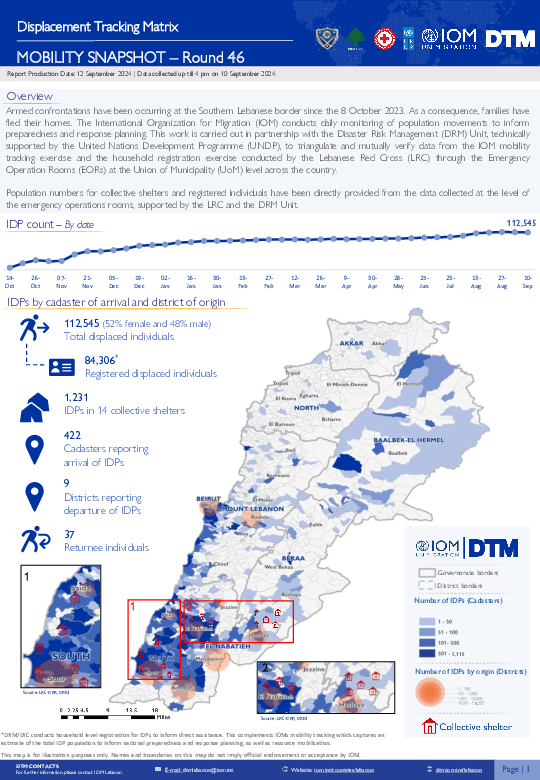
Since October 8 there has been an increase in cross-border incidents between Israel and Lebanon, resulting in the displacement of people both within the South and elsewhere within the country. Since October 10, the Displacement Tracking Matrix (DTM) has been conducting the daily monitoring of population movements. The objective of the exercise is to inform preparedness and response planning.
