
Dec 23 2021
- Event Tracking
- Mobility Tracking
L’évaluation rapide de l’OIM (Emergency Tracking Tool, ETT) est un outil mis en place dans le but de collecter des informations sur les mouvements importants et soudains de populations. Ces informations sont collectées à la suite de visites sur le terrain et ou d’entretiens téléphoniques avec les informateurs clés des sites de déplacement ou des communautés d’accueil. D’autres informations sont ensuite recueillies et analysées à partir des outils d’Evaluation Rapide Multisectorielle (ERM). Ce rapport synthétique présente les résultats de l’évaluation menée sur terrain du 21 au 23 décembre 2021.

Jan 23 2022
- Event Tracking
- Mobility Tracking
Between the 17th and 23rd of January 2022, a total of 3,409 movements were recorded in Adamawa and Borno States. The recorded movements consisted of 3,072 arrivals and 337 departures. Arrivals were recorded at locations in Askira/Uba, Bama, Biu, Damboa, Gwoza, Kala/Balge, Monguno and Ngala Local Government Areas (LGAs) of the most conflict-affected Borno State and in Fufore, Girei, Gombi, Hong, Lamurde, Maiha, Michika, Mubi South, Song, Yola North and Yola South LGAs of Adamawa State.
Departures were recorded in Konduga LGA of Borno, and Fufore, Gombi, Hong, Lamurde, Maiha, Mubi South, Song, and Yola South LGAs of Adamawa State.
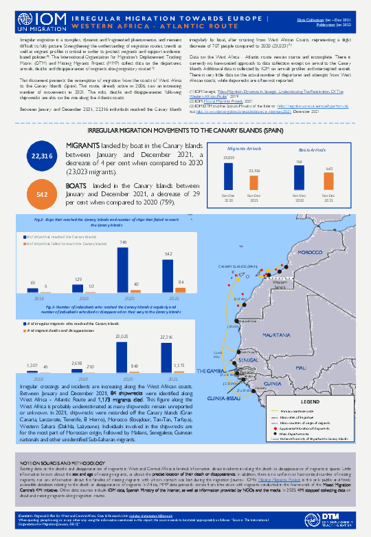
Irregular migration is a complex, dynamic and fragmented phenomenon, and remains difficult to fully picture. Strengthening the understanding of migration routes, trends as well as migrant profiles is critical in order to protect migrants and support evidence-based policies. The International Organization for Migration's Displacement Tracking Matrix (DTM) and Missing Migrants Project (MMP) collect data on the departures, arrivals, deaths and disappearances of migrants along migratory routes.
This document presents the resumption of migration from the coasts of West Africa to the Canary Islands (Spain). This route, already active in 2006, saw an increasing number of movements in 2021. The risks, deaths and disappearances following shipwrecks are also on the rise along the Atlantic coasts.
Between January and December 2021, 22,316 individuals reached the Canary Islands irregularly by boat, after crossing from West African Coasts, representing a slight decrease of 707 people compared to 2020 (23,023)
Dec 31 2021
- Flow Monitoring
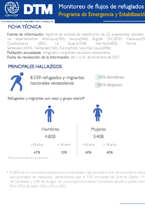
El 86% de los nacionales venezolanos entrevistados (as) durante el mes de noviembre indican que proceden de Venezuela, destacándose que el 15% provienen de Distrito Capital, 11% de Carabobo y 10% de Aragua. En una proporción menor provienen de otros países como: Perú (7%), Ecuador (5%) y Chile (2%).
Oct 22 2021
- Other
- Survey
- Flow Monitoring Survey
- Flow Monitoring
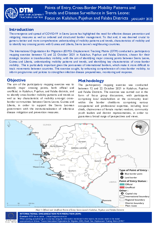
The emergence and spread of COVID-19 in Sierra Leone has highlighted the need for effective disease prevention and mitigating measures as well as ordered and structured border management. To that end, it was deemed crucial to garner a better and more comprehensive understanding of mobility patterns and trends, characteristics of mobility and to identify key crossing points with Guinea and Liberia, Sierra Leone’s neighbouring countries.
The International Organization for Migration (IOM)’s Displacement Tracking Matrix (DTM) conducted a participatory mapping exercise between 12 and 22 October 2021 in Kailahun, Pujehun and Falaba Districts, chosen for their strategic location in transboundary mobility, with the aim of identifying major crossing points between Sierra Leone, Guinea and Liberia, understanding mobility patterns and trends, and identifying key characteristics of cross-border mobility. This is particularly important given the porousness of international borders, which make it more difficult to track movements between countries. This exercise sought, by enhancing comprehension of cross-border mobility, to inform programmes and policies to strengthen infection disease preparedness, monitoring and response.

Nov 25 2021
- Site Assessment
- Mobility Tracking
From 3 to 25 November 2021, in close coordination with provincial government and INGD partners, the International Organization for Migration (IOM)’s Displacement Tracking Matrix (DTM) teams conducted Multi-Sectoral Location Assessments (MSLA) in 66 sites hosting 194,837 internally displaced persons (IDPs) in Cabo Delgado province, 1 site with 6,567 IDPs in Nampula province, and 2 sites with 285 IDPs in Niassa province, in response to the mass displacements caused by the insecurity situation in the north. In all sites, the majority of IDPs were displaced by the insecurity situation. Of the total 201,689 individuals in the assessed sites, 49,955 (or 25%) are women, 38,546 (19%) are men, and 113,188 (56%) are children.

Nov 05 2021
- Mobility Tracking
O aumento dos incidentes de segurança no norte de Moçambique desde 2017 resultou no deslocamento da população, bem como nas subsequentes necessidades humanitárias. Para melhor compreender o alcance das tendências e necessidades das populações deslocadas, a Organização Internacional para as Migrações (OIM) activou a DTM na província de Cabo Delgado em Fevereiro de 2019.
A DTM tem pontos focais e enumeradores em 277 localidades da província de Cabo Delgado e recolhe dados em estreita coordenação com o Governo. Esta 14ª ronda de avaliação abrangeu também as províncias vizinhas de Inhambane (2 localidades, contra 6 reportadas na ronda anterior; a diminuição foi atribuída à realocação) Nampula (53 localidades), Niassa (14 localidades), assim como as províncias da Zambézia (6 localidades), e Sofala (2 localidades).

Oct 23 2021
- Mobility Tracking
De 22 de Setembro a 23 de Outubro de 2021, em estreita coordenação com o governo provincial e os parceiros do INGD, as equipas da Matriz de Mointoria de Deslocamentos (DTM) da Organização Internacional para as Migrações (OIM) realizaram Avaliações Multisectoriais de Locais (MSLA) em 59 locais que acolhem 192.721 deslocados internos na província de Cabo Delgado, 1 local com 5.934 deslocados internos na província de Nampula, e 2 locais com 336 deslocados internos na província do Niassa, em resposta aos deslocamentos em massa causados pela situação de insegurança no norte. Em todos os locais, a maioria dos deslocados internos foram deslocados pela situação de insegurança. Do total de 198.991 indivíduos nos locais avaliados, 62.045 (ou 31%) são mulheres, 32.022 (16%) são homens, e 107.948 (53%) são crianças. Os dados demográficos nas Figuras 2 e 3 são uma amostra recolhida através da amostragem aleatória de vinte agregados familiares por local.
- Site Assessment
- Mobility Tracking
Nov 25 2021
Population Groups
Survey Methodology
Unit of Analysis Or Observation
Type of Survey or Assessment
Keywords
Geographical Scope
Administrative boundaries with available data
The current dataset covers the following administrative boundaries

The current outbreak of COVID-19 has affected global mobility in complex and unprecedented ways in the form of various travel restrictions, suspension of air travel, and border closures. To better understand this, the International Organization for Migration (IOM) has developed a global mobility database to map these impacts on human mobility, across global, regional, and country levels. Furthermore, COVID-19 has had a disproportionate impact on vulnerable populations in camps and camp-like settings as well as exacerbated the vulnerabilities of mobile populations who may now be stranded owing to COVID-19 related mobility restrictions. This data is particularly important when addressing specific needs faced by migrants and mobile populations.
IOM has developed a global mobility database mapping the status of different Points of Entry (PoE) and Key Locations of Internal Mobility, globally. These include airports, land border crossing points (could be rail or road), blue border crossing points (sea, river or lake), internal transit points, and areas of interest. For each point of entry, data is collected on the type of restriction, measured applied, and the timeframe, as well as the population category that may be affected by the restrictive measures. This workstream uses direct input from IOM missions and this dashboard displays regularly updated mobility restrictions at the location level.

DTM API
Making global IDPs data accessible and reliable
The Displacement Tracking Matrix application programming interface (API) accelerates secure sharing of IDPs’ data, simplifying access to data across users and partners to support action, insight and foresight.