
Dec 31 2021
- Event Tracking
- Flow Monitoring
La transhumance est une pratique de longue date en Mauritanie où elle a évolué au cours des dernières décennies telles que la raréfaction des ressources impliquant la redéfinition des routes empruntées par les troupeaux. Par conséquent, des conflits peuvent survenir lorsque les agriculteurs et les éleveurs transhumants. Dans le cadre du Suivi des Mouvements de Transhumance, l’OIM met en œuvre un système d’alerte qui a pour objectif de recenser les mouvements inattendus de bétail et les conflits ou catastrophes naturelles liés à l’utilisation des ressources naturelles et aux interactions entre agriculteurs et éleveurs, de comprendre les modes de résolution de conflits existants et d’informer les autorités compétentes, dans l’objectif de réduire les tensions dans les régions d’intervention. Ce tableau de bord présente les informations fournies par le biais de 21 informateurs clés, présents dans huit régions (Assaba, Brakna, Gorgol, Guidimakha, Hodh El Chargui, Hodh El Gharbi, Tagant et Trarza) pendant le mois de décembre 2021.
- Event Tracking
- Mobility Tracking
Feb 05 2022
Population Groups
Survey Methodology
Unit of Analysis Or Observation
Type of Survey or Assessment
Keywords
Geographical Scope
Administrative boundaries with available data
The current dataset covers the following administrative boundaries
- Mobility Tracking
- Baseline Assessment
Jan 31 2022
Population Groups
Survey Methodology
Unit of Analysis Or Observation
Type of Survey or Assessment
Keywords
Geographical Scope
Administrative boundaries with available data
The current dataset covers the following administrative boundaries

Feb 02 2022
- Event Tracking
Following these events, rapid assessments were conducted by the International Organization for Migration (IOM) in collaboration with the National Institute for Disaster Management and Risk Reduction (INGD), from the 25 January 2022. Rapid assessments are still ongoing with a focus on understanding the extent of initial displacements as well as damages to houses and facilities across all affected localities in Tete, Niassa, Sofala, Nampula and Zambezia Provinces.
As a result of the impact of Tropical Depression Ana, an estimate of 50,768 families had their houses completely/partially damaged in the districts assessed so far. Of these 72% are in Nampula (36,681 houses), 18% in Zambezia (8,913 houses), 8% in Sofala (4,279 households) and 0.2% in Niassa (83 households). Assessment teams have completed data collection in 2 locations across Tete Sede-recording 812 houses (2%) completely/partially damaged. Further assessments in Teteare ongoing to evaluate extent of displacements across Mutarara, Dia and Zambue districts. In addition, 21 tents and 16 emergency shelters were completely or partially destroyed due to the rain and strong winds.
IOM/INGD identified 437 latrines and 8 water points damaged. Moreover, localities assessed so far identify at least 181 schools reporting partial and major damaged. Affected schools are in Nampula (69), Zambezia (87), Sofala (25) provinces. A total of 444 classrooms were completely or partially damaged in the affected schools.
In assessed locations
- Other
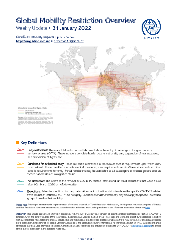
The current outbreak of COVID-19 has affected global mobility in the form of various travel disruptions and restrictions. To better understand how COVID-19 affects global mobility, DTM has developed a COVID-19 database mapping the different restrictions to provide a global overview. For this, DTM uses the IATA site as the primary source of restrictions with the information reported per country and territory, and to the country of application.
Data collected includes:
- Date of restriction
- Country, territory or area of restriction
- Countries, territories or areas on which restrictions were imposed
- Type of restriction- total restriction, or conditional restriction – such as medical/ and or visa restriction
This DTM COVID-19 Travel Restrictions Output presents an analysis based on country imposing, the country being imposed upon, and the aggregation of the restriction type. The aim of the data analysis is to provide an overview of the COVID-19 outbreak on global mobility and to help identify and develop responses.
Countries in this response
- Active DTM operation
- Past DTM operation
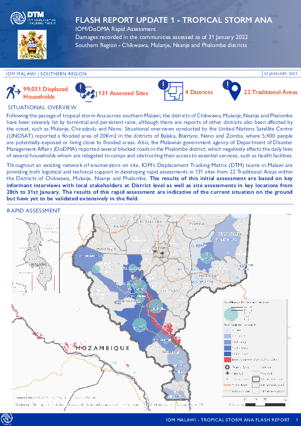
Jan 31 2022
- Event Tracking
Following the passage of tropical storm Ana across southern Malawi, the districts of Chikwawa, Mulanje, Nsanje and Phalombe have been severely hit by torrential and persistent rains, although there are reports of other districts also been affected by the onset, such as Mulanje, Chiradzulu and Neno. Situational overviews conducted by the United Nations Satellite Centre (UNOSAT) reported a flooded area of 20Km2 in the districts of Balaka, Blantyre, Neno and Zomba, where 5,400 people are potentially exposed or living close to flooded areas. Also, the Malawian government agency of Department of Disaster Management Affairs (DoDMA) reported several blocked roads in the Phalombe district, which negatively affects the daily lives of several households whom are relegated to camps and obstructing their access to essential services, such as health facilities.
Throughout an existing network of enumerators on site, IOM’s Displacement Tracking Matrix (DTM) teams in Malawi are providing both logistical and technical support in developing rapid assessments in 131 sites from 22 Traditional Areas within the Districts of Chikwawa, Mulanje, Nsanje and Phalombe. The results of this initial assessment are based on key informant interviews with local stakeholders at District level as well as site assessments in key locations from 28th to 31st January. The results of this rapid assessment are indicative of the current situation on the ground but have yet to be validated extensively in the field.
Jan 30 2022
- Event Tracking
- Mobility Tracking
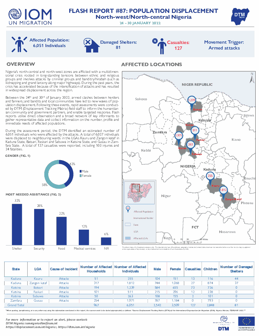
Nigeria's north-central and north-west zones are afflicted with a multidimensional crisis rooted in long-standing tensions between ethnic and religious groups and involves attacks by criminal groups and banditry/hirabah (such as kidnapping and grand larceny along major highways). During the past years, the crisis has accelerated because of the intensification of attacks and has resulted
in widespread displacement across the region.
Between the 24th and 30th of January 2022, armed clashes between herders and farmers; and bandits and local communities have led to new waves of population displacement. Following these events, rapid assessments were conducted by DTM (Displacement Tracking Matrix) field staff to inform the humanitarian community and government partners, and enable targeted response. Flash reports utilise direct observation and a broad network of key informants to gather representative data and collect information on the number, profile and immediate needs of affected populations.

Jan 31 2022
- Mobility Tracking
- Baseline Assessment
- Points of Entry (PoE)
During the COVID-19 pandemic, IOM's Displacement Tracking Matrix (DTM), in collaboration with the World Health Organization (WHO), monitors the movements to and from Nigeria's Adamawa and Borno States in the North East Nigeria. Assessments are conducted at Points of Entry located along the border with Cameroon.
During the period 01 - 31 January 2022, 1,063 movements were observed at three Points of Entry in Borno state. Of the total movements recorded, 541 were incoming from the Far North Region in Cameroon while 15 were incoming from Bol, three from Adre and six from Ndjamena in Chad republic. Additionally, 492 outgoing movements were recorded from Borno State to the
Far North Region in Cameroon and six outgoing movement to Lai and Bol in Chad republic.

Jan 28 2022
- Mobility Tracking
- Baseline Assessment
- Points of Entry (PoE)
During the COVID-19 pandemic, IOM's Displacement Tracking Matrix (DTM), in collaboration with the World Health Organization (WHO), monitors the movements to and from Nigeria's Adamawa and Borno States in north-east Nigeria. Assessments are conducted at Points of Entry located along the border with Cameroon.
During the period 22 - 28 January 2022, 242 movements were observed at three Points of Entry in Borno state. Of the total movements recorded, 107 were incoming from the Far North Region in Cameroon, while 135 outgoing movements were recorded from Borno State to the Far North Region in Cameroon.

DTM API
Making global IDPs data accessible and reliable
The Displacement Tracking Matrix application programming interface (API) accelerates secure sharing of IDPs’ data, simplifying access to data across users and partners to support action, insight and foresight.