- Mobility Tracking
- Event Tracking
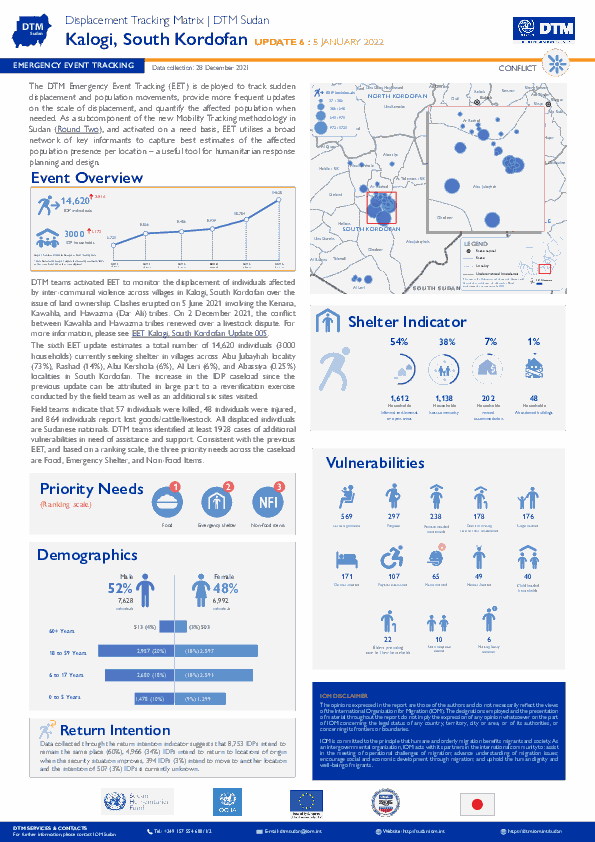
The DTM Emergency Event Tracking (EET) is deployed to track sudden displacement and population movements, provide more frequent updates on the scale of displacement, and quantify the affected population when needed. As a subcomponent of the new Mobility Tracking methodology in Sudan (Round Two), and activated on a needs basis, EET utilises a broad network of key informants to capture best estimates of the affected population presence per location – a useful tool for humanitarian response planning and design.
- Event Tracking
- Mobility Tracking
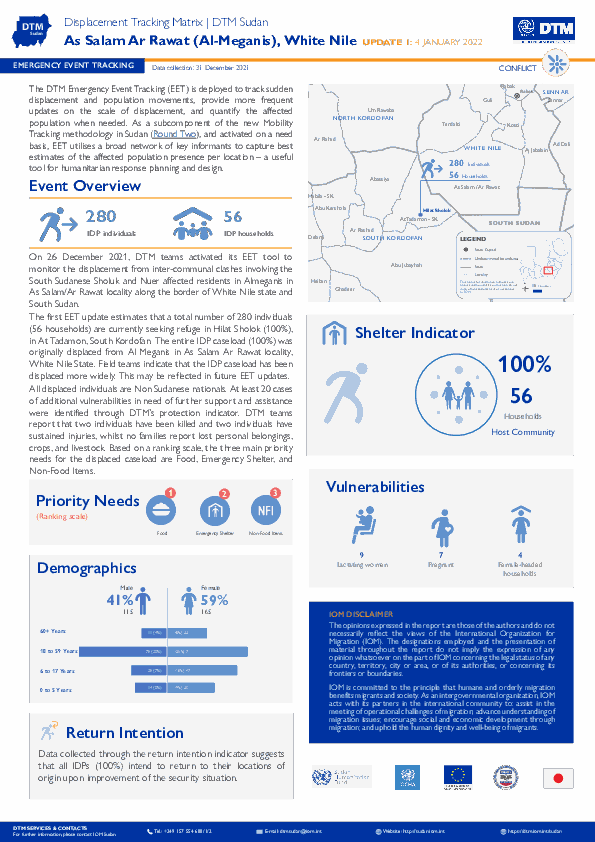
The DTM Emergency Event Tracking (EET) is deployed to track sudden displacement and population movements, provide more frequent updates on the scale of displacement, and quantify the affected population when needed. As a subcomponent of the new Mobility Tracking methodology in Sudan (Round Two), and activated on a needs basis, EET utilises a broad network of key informants to capture best estimates of the affected population presence per location – a useful tool for humanitarian response planning and design.

Jan 01 2022
- Rapid Emergency Registration
- Mobility Tracking
IOM Yemen DTM’s Rapid Displacement Tracking (RDT) tool collects data on numbers of households forced to flee on a daily basis from their locations of origin or displacement, allowing for regular reporting of new displacements in terms of numbers, geography, and needs. It also tracks Returnees who returned to their location of origin.
From 01 January 2021 to 1 January 2022, IOM Yemen DTM estimates that 26,227 households (HH) (157,362 Individuals) have experienced displacement at least once.
Since the beginning of 2021, DTM also identified 4,440 displaced households who left their locations of displacement and either moved back to their place of origin or another location.
Between 26 December 2021 and 01 January 2022, IOM Yemen DTM tracked 466 households (2,796 individuals) displaced at least once. The top three governorates and districts where people moved into/within are:
- Al Jawf (200 HH) – Khab wa Ash Shaf (200 HH) district. All displacements in the governorate were internal.
- Al Hodeidah(121 HH) – Hays (78 HH), Al Khukhah (43 HH) districts. Most displacements in the governorate originated from Al Hodeidah and Taiz.
- Marib (86 HH) – Marib City (75 HH), Marib (11 HH) districts. Most displacements in the governorate originated from Marib and Ad Dali.
Most displacements resulted from the increased conflict in the following governorates and districts.
- Al Jawf (202 HH) – Khab wa Ash Shaf (202 HH) district.
- Al Hodeidah (77 HH) – Hays (64 HH), At Tuhayta (6 HH( districts.
- Marib (61 HH) – Marib (23 HH), Al Jubah (20 HH), Marib City (11 HH) districts.
- Event Tracking
- Mobility Tracking
Jan 01 2022
Population Groups
Survey Methodology
Unit of Analysis Or Observation
Type of Survey or Assessment
Keywords
Geographical Scope
Administrative boundaries with available data
The current dataset covers the following administrative boundaries

Oct 31 2021
- Survey
- Flow Monitoring
La transhumance est une pratique de longue date en Mauritanie où elle a évolué au cours des dernières décennies telles que la raréfaction des ressources impliquant la redéfinition des routes empruntées par les troupeaux. Par conséquent, des conflits peuvent survenir lorsque les agriculteurs et les éleveurs transhumants. Dans le cadre du Suivi des Mouvements de Transhumance, l’OIM met en œuvre un système d’alerte qui a pour objectif de recenser les mouvements inattendus de bétail et les conflits ou catastrophes naturelles liés à l’utilisation des ressources naturelles et aux interactions entre agriculteurs et éleveurs, de comprendre les modes de résolution de conflits existants et d’informer les autorités compétentes, dans l’objectif de réduire les tensions dans les régions d’intervention. Ce tableau de bord présente les informations fournies par le biais de 37 relais communautaires, présents dans sept régions (Trarza, Brakna, Gorgol, Guidimakha, Assaba, Hodh El Chargui et Hodh El Gharbi) pendant le mois d’octobre 2021.

Dec 28 2021
- Event Tracking
- Mobility Tracking
During the reporting period (23 to 28 December 2021), a total of 16 movements were recorded - 6 transits (115 individuals), 2 departures (33 individuals), 4 arrivals (26 individuals), and 4 intended return movements (74 individuals). The largest individual arrival was recorded in Ancuabe (19 individuals). The largest intended return movements were observed in Nanagde (74 individuals). The largest transit was recorded in Nangade (115 individuals). The largest departures were recorded in Balama (24 individuals). Of the total population 9 per cent were displaced for the first time, and 91 per cent of reported IDPs had been displaced more than once prior to this latest movement.
Dec 28 2021
- Event Tracking
- Site Assessment
- Mobility Tracking
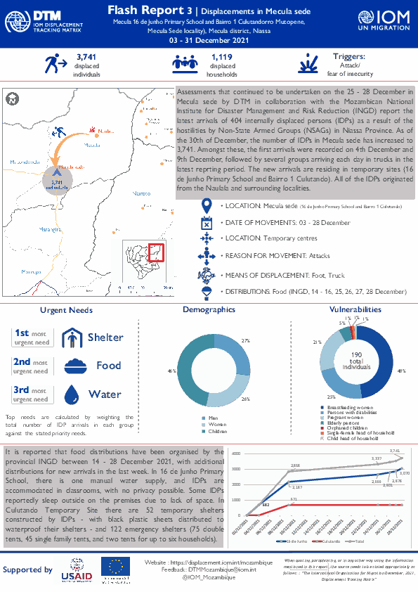
Assessments that continued to be undertaken on the 25 - 28 December in Mecula sede by DTM in collaboration with the Mozambican National Institute for Disaster Management and Risk Reduction (INGD) report the latest arrivals of 404 internally displaced persons (IDPs) as a result of the hostilities by Non-State Armed Groups (NSAGs) in Niassa Province. As of the 30th of December, the number of IDPs in Mecula sede has increased to 3,741. Amongst these, the first arrivals were recorded on 4th December and 9th December, followed by several groups arriving each day in trucks in the latest reprting period. The new arrivals are residing in temporary sites (16 de Junho Primary School and Bairro 1 Culutando). All of the IDPs originated from the Naulala and surrounding localities.

Dec 26 2021
- Event Tracking
- Mobility Tracking
The DTM Emergency Tracking Tool (ETT) is deployed to track and collect information on large and sudden population movements, provide frequent updates on the scale of displacement and quantify the affected population when needed. As a subcomponent of the Mobility Tracking methodology in Nigeria, ETT utilizes direct observation and a broad network of key informants to capture best estimates of the affected population per location, enabling targeted humanitarian response planning.
Between 20 and 26 December 2021, a total of 3,875 movements were recorded in the states of Adamawa and Borno. The recorded movements consisted of 3,381 arrivals and 494 departures. Arrivals were recorded at locations in Askira/Uba, Bama, Gwoza, Kala/Balge, Monguno and Ngala Local Government Areas (LGAs) of the most conflict-affected state of Borno and in Fufore, Gombi, Hong, Maiha, Michika, Mubi South, Yola North and Yola South LGAs of Adamawa.
Departures were recorded in Askira/Uba, Kala/Balge and Konduga LGAs of Borno, and Fufore, Lamurde, Maiha, Michika, Song and Yola North LGAs of Adamawa.
ETT assessments identified the following movement triggers: voluntary relocation (1,498 individuals or 39%), conflicts/attacks (944 individuals or 24%), camp closure/government-assisted relocation (877 individuals or 23%), poor living conditions (349 individuals or 9%), improved security (112 individuals or 3%), fear of attacks (59 individuals or 1%) and seasonal farming (36 individuals or 1%).
- Other
- Mobility Tracking
- Site Assessment
Oct 15 2021
Population Groups
Survey Methodology
Unit of Analysis Or Observation
Type of Survey or Assessment
Keywords
Geographical Scope
Administrative boundaries with available data
The current dataset covers the following administrative boundaries
- Other
- Mobility Tracking
- Site Assessment
Oct 15 2021
Population Groups
Survey Methodology
Unit of Analysis Or Observation
Type of Survey or Assessment
Keywords
Geographical Scope
Administrative boundaries with available data
The current dataset covers the following administrative boundaries

DTM API
Making global IDPs data accessible and reliable
The Displacement Tracking Matrix application programming interface (API) accelerates secure sharing of IDPs’ data, simplifying access to data across users and partners to support action, insight and foresight.