
- Other
The current outbreak of COVID-19 has affected global mobility in the form of various travel disruptions and restrictions. To better understand how COVID-19 affects global mobility, DTM has developed a COVID-19 database mapping the different restrictions to provide a global overview. For this, DTM uses the IATA site as the primary source of restrictions with the information reported per country and territory, and to the country of application.
Data collected includes:
- Date of restriction
- Country, territory or area of restriction
- Countries, territories or areas on which restrictions were imposed
- Type of restriction- total restriction, or conditional restriction – such as medical/ and or visa restriction
This DTM COVID-19 Travel Restrictions Output presents an analysis based on country imposing, the country being imposed upon, and the aggregation of the restriction type. The aim of the data analysis is to provide an overview of the COVID-19 outbreak on global mobility and to help identify and develop responses.
Jan 31 2022
- Mobility Tracking
- Baseline Assessment
This IOM Displacement Tracking Matrix (DTM) report presents the data and findings on internally displaced persons (IDPs) and returnees between December 2021 – January 2022, representing round 40 of the DTM Mobility Tracking in Libya. Consistent with the trend observed throughout 2021, in this round of reporting, the numbers of IDPs within the country continued decreasing, with a parallel increase in the number of returnees. As compared to 661,892 returnees identified in round 39, the number of those identified during round 40 increased to 673,554 individuals. This indicates a slight increase in the percentage of those returning (2%), accounting for a total increase of 19 per cent since October 2020 ceasefire in Libya.
Jan 31 2022
- Mobility Tracking
- Baseline Assessment
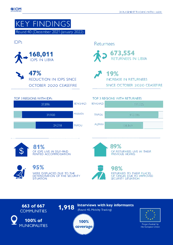
This infographic presents the key findings of Round 40 of the mobility tracking component of the Displacement Tracking Matrix (DTM) programme in Libya.
- Mobility Tracking
- Baseline Assessment
Jan 31 2022
Population Groups
Survey Methodology
Unit of Analysis Or Observation
Type of Survey or Assessment
Keywords
Geographical Scope
Administrative boundaries with available data
The current dataset covers the following administrative boundaries
Mar 06 2022
- Event Tracking
- Mobility Tracking
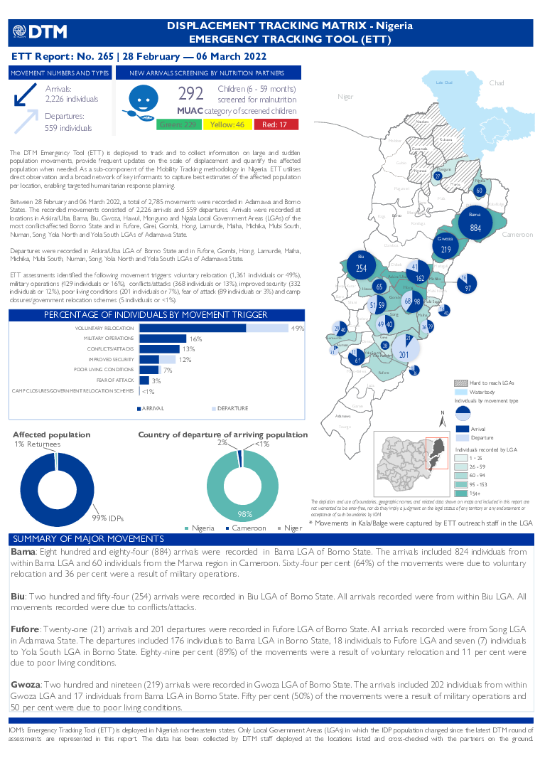
The DTM Emergency Tracking Tool (ETT) is deployed to track and to collect information on large and sudden population movements, provide frequent updates on the scale of displacement and quantify the affected population when needed. As a subcomponent of the Mobility Tracking methodology in Nigeria, ETT utilizes direct observation and a broad network of key informants to capture best estimates of the affected population per location, enabling targeted humanitarian response planning.
Between 28 February and 06 March 2022, a total of 2,785 movements were recorded in Adamawa and Borno States. The recorded movements consisted of 2,226 arrivals and 559 departures. Arrivals were recorded at locations in Askira/Uba, Bama, Biu, Gwoza, Hawul, Monguno and Ngala Local Government Areas (LGAs) of the most conflict-affected Borno State and in Fufore, Girei, Gombi, Hong, Lamurde, Maiha, Michika, Mubi South, Numan, Song, Yola North and Yola South LGAs of Adamawa State.
Departures were recorded in Askira/Uba LGA of Borno State and in Fufore, Gombi, Hong, Lamurde, Maiha, Michika, Mubi South, Numan, Song, Yola North and Yola South LGAs of Adamawa State.
ETT assessments identified the following movement triggers: voluntary relocation (1,361 individuals or 49%), military operations (429 individuals or 16%), conflicts/attacks (368 individuals or 13%), improved security (332 individuals or 12%), poor living conditions (201 individuals or 7%), fear of attack (89 individuals or 3%) and camp closures/government relocation schemes (5 individuals or <1%).

Dec 30 2021
- Mobility Tracking
- Baseline Assessment
This factsheet presents key findings from the period 16 November to 30 December 2021, this represents the results from the Round 40 of Displacement Tracking Matrix (DTM) assessments carried out by the International Organization for Migration (IOM) in North-east Zone.
During Round 40, DTM identified 2,171,652 IDPs (446,740 households) as well as 1,960,558 Returnees (317,885 households).
Dec 31 2021
- Mobility Tracking
- Baseline Assessment
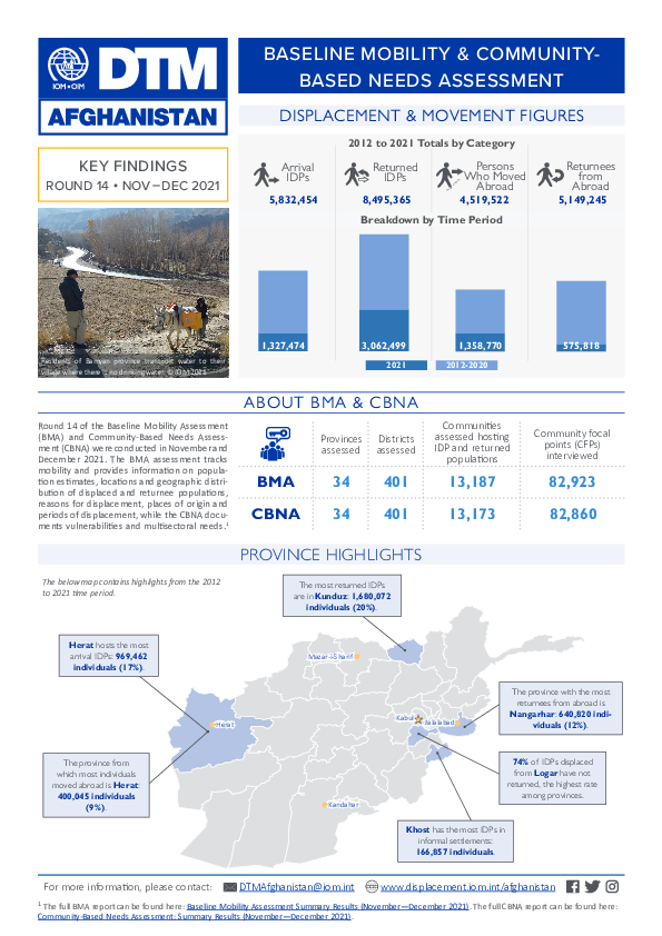
Round 14 of the Baseline Mobility Assessment (BMA) and Community-Based Needs Assessment (CBNA) were conducted in November and December 2021. The BMA assessment tracks mobility, provide information on population estimates, locations and geographic distribution of displaced, return and migrant populations, reasons for displacement, places of origin and periods of displacement, while the CBNA documents vulnerabilities and multisectoral needs.
The full BMA report can be found here: Baseline Mobility Assessment Summary Results (November—December 2021).
The full CBNA report can be found here:
Community-Based Needs Assessment: Summary Results (November—December 2021).
- Flow Monitoring Survey
- Flow Monitoring
Jan 31 2022
Population Groups
Survey Methodology
Unit of Analysis Or Observation
Type of Survey or Assessment
Keywords
Geographical Scope
Administrative boundaries with available data
The current dataset covers the following administrative boundaries
- Flow Monitoring Survey
- Flow Monitoring
Dec 31 2021
Population Groups
Survey Methodology
Unit of Analysis Or Observation
Type of Survey or Assessment
Keywords
Geographical Scope
Administrative boundaries with available data
The current dataset covers the following administrative boundaries
- Flow Monitoring Survey
- Flow Monitoring
Nov 30 2021
Population Groups
Survey Methodology
Unit of Analysis Or Observation
Type of Survey or Assessment
Keywords
Geographical Scope
Administrative boundaries with available data
The current dataset covers the following administrative boundaries

DTM API
Making global IDPs data accessible and reliable
The Displacement Tracking Matrix application programming interface (API) accelerates secure sharing of IDPs’ data, simplifying access to data across users and partners to support action, insight and foresight.