
Jun 30 2022
- Other
- Survey
- Flow Monitoring Survey
- Flow Monitoring
- Mobility Tracking
- Baseline Assessment
Ce rapport est composé d’un ensemble d’infographies et de cartes des différentes tendances migratoires au Mali. Il traite d’un grand nombre des mouvements de population recensés depuis, vers et au sein du territoire malien et dresse une vue générale des populations en mouvements.
Plusieurs types de mobilités sont traitées sur ce document: les mouvements économiques internes ou vers l’étranger, les transhumances, les déplacements internes forcés, les retours, etc. Il est intéressant de remarquer que, très souvent, ces différentes mobilités se croisent. Ce rapport tente de faire ce lien (par exemple entre la migration vers les sites d’orpaillage et la migration vers le Nord du Mali) mais de plus amples recherches seraient nécessaires afin de mieux saisir ces dynamiques.
Ce rapport est le résultat d’une compilation de diverses bases de données et rapports provenant de différentes sources d’informations qui sont indiquées dans chacune des pages dans l’encadré « Détails et Sources ». Certaines informations et tracés sont également tirés de discussions avec des informateurs clés.

he DTM Emergency Tracking Tool (ETT) is deployed to track and to collect information on large and sudden population movements, provide frequent updates on the scale of displacement and quantify the affected population when needed. As a sub-component of the Mobility Tracking methodology in Nigeria, ETT utilises direct observation and a broad network of key informants to capture best estimates of the affected population per location, enabling targeted humanitarian response planning.
Between 15 and 21 August 2022, a total of 2,562 new arrivals were recorded in locations in Adamawa and Borno States. The new arrivals were recorded at locations in Askira/Uba, Bama, Dikwa, Damboa, Gwoza, Kala Balge, Monguno and Ngala Local Government Areas (LGAs) of the most conflict-affected state of Borno and in Demsa, Fufore, Girei, Gombi, Hong, Lamurde, Maiha, Michika, Mubi South, Mubi North, Song and Yola South LGAs of Adamawa State.

Aug 14 2022
- Mobility Tracking
- Event Tracking
he DTM Emergency Tracking Tool (ETT) is deployed to track and to collect information on large and sudden population movements, provide frequent updates on the scale of displacement and quantify the affected population when needed. As a sub-component of the Mobility Tracking methodology in Nigeria, ETT utilises direct observation and a broad network of key informants to capture best estimates of the affected population per location, enabling targeted humanitarian response planning.
Between 08 and 14 August 2022, a total of 3,327 new arrivals were recorded in locations in Adamawa and Borno States. The new arrivals were recorded at locations in Askira/Uba, Bama, Dikwa, Gwoza, Kala Balge, and Monguno Local Government Areas (LGAs) of the most conflict-affected state of Borno and in Fufore, Girei, Gombi, Hong, Lamurde, Maiha, Michika, Mubi South, Numan, Song, Yola North and Yola South LGAs of Adamawa State.

Aug 28 2022
- Mobility Tracking
- Event Tracking
On 23 August armed bandits reportedly attacked Soron Yamma community in Soron Yamma ward in Binji LGA of Sokoto state. This attack affected 315 individuals and led to the displacement of 314 individuals from Soron Yamma community to Behind Ubandoma House Gwaiwa Ekka community in Arkilla ward of Wamako LGA. In the attack, one fatality was reported and 2 individuals were injured.
On 28 August, windstorm was reported in the Kofar Yandaka community of Wakilin Arewa (B) ward . The windstorm affected 179 individuals and led to displacement of 178 individuals in Kofar Yandaka community to Bayan Government Day community in same ward. One fatality was reported and 3 individuals were injured.
Following these events, rapid assessments were conducted by DTM (Displacement Tracking Matrix) field staff to inform the humanitarian community and government partners to enable targeted response. Flash reports utilise direct observation and a broad network of key informants to gather representative data and collect information on the number, profile and immediate needs of affected populations.

The Horn of Africa and Yemen is one of the busiest and riskiest migration corridors in the world travelled by hundreds of thousands of migrants, the majority of whom travel in an irregular manner, often relying on smugglers to facilitate movement along the Eastern Route. This regional report provides monthly updates on the complex migratory dynamics through Djibouti, Somalia, Yemen and Ethiopia based on diverse data sources and consultations with key informants in the four countries. Moreover, it provides information on the main protection concerns for migrants along the journey, information on the spill over effects of the conflict in Northern Ethiopia observed at the border between Ethiopia, Kenya and Sudan, a specific focus on children and information on the returns from Saudi Arabia to Ethiopia, Somalia and Yemen.

Aug 28 2022
- Mobility Tracking
- Event Tracking
L’objectif de l’outil de suivi des urgences est de rassembler des informations sur les mouvements significatifs et soudains de populations. Ce tableau de bord présente des informations sur des mouvements de personnes des localités de Tchika, Balgaram, Goretal, Goutoum arrondissement de Hilé-Alifa et Karema, Naga, Gore Tchandji arrondissement de Darak, vers les localités de Hilé –Alifa Centre, Hilé Alifa 2 et Abassouni survenus le 29 août 2022 dans l’arrondissement de Hilé-Alifa
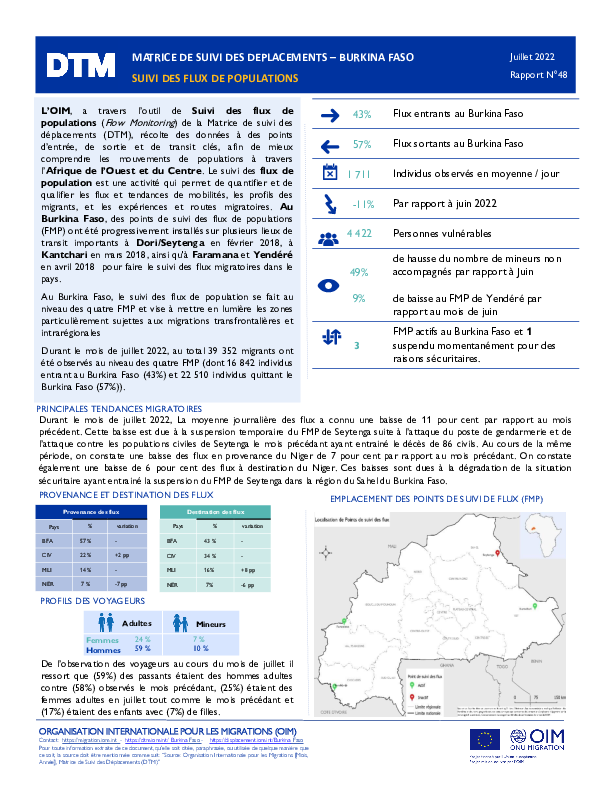
Jul 31 2022
- Flow Monitoring
Afin de mieux comprendre les mouvements et tendances migratoires en Afrique de l’Ouest et du Centre, l’OIM, à travers la Matrice de suivi des déplacements (Displacement Tracking Matrix, DTM), met en œuvre l’activité de Suivi des flux de populations (Flow Monitoring, FM).
Au Burkina Faso, la DTM recueille des données au niveau de 4 Points de suivi des flux (Flow Monitoring Points, FMP) que sont Dori/Seytenga, Kantchari, Faramana et Yendéré répartis dans 4 régions afin d’obtenir une meilleure compréhension de l’ampleur, des tendances, des caractéristiques socio-démographiques et des parcours des flux de voyageurs traversant ces différents points.
Ce rapport présente les données recueillies dans le cadre des activités d’enregistrement des flux durant le mois de Juillet 2022.

Aug 26 2022
- Event Tracking
690 nouveaux déplacements et 1 411 nouvelles arrivées de personnes déplacées internes ont été rapportés pendant la période d’évaluation dans les 316 quartiers évalués. La plupart de ces déplacements ont eu lieu dans les communes de Cité Soleil (quartiers de Projet Drouillard et Brouklin) et Croix-Des-Bouquets (quartier de Corail - Jerusalem). En matière de sécurité, la situation reste toujors tendue, avec 29 quartiers affectés par des violences généralisées et sept par des violences ciblées. 30 quartiers ont été touchés par des innondations, une situation aggravée par le mauvais état des infrastructures de canalisation dans la ZMPP. Durant la période d’évaluation du 13 au 19 août, la DTM estimait 283 nouveaux déplacements et 723 nouvelles arrivées de personnes déplacées dans les 341 quartiers évalués.
- Mobility Tracking
- Event Tracking
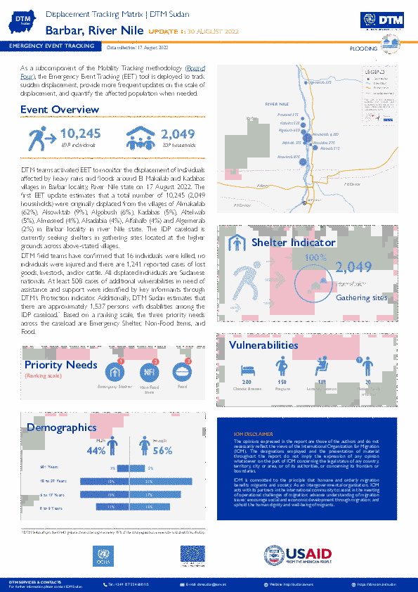
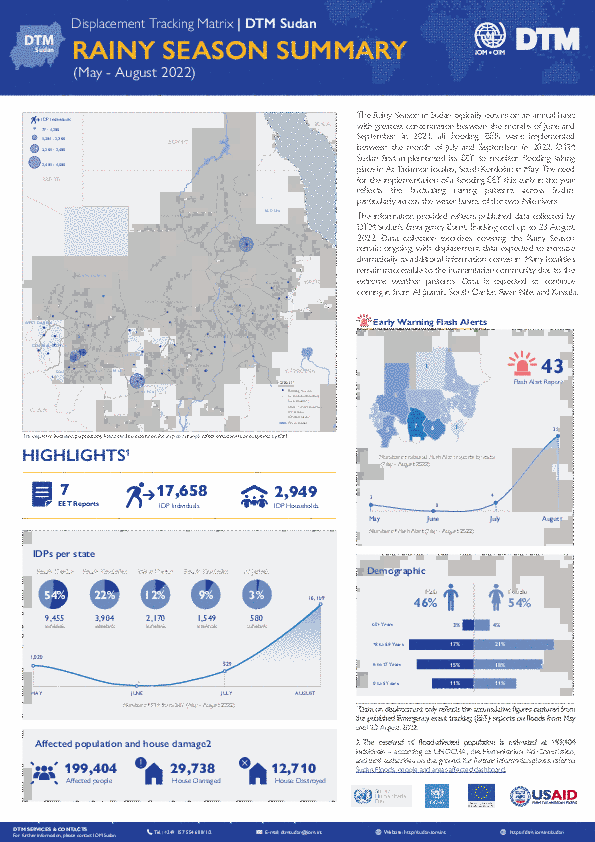
The DTM Emergency Event Tracking (EET) is deployed to track sudden displacement and population movements, provide more frequent updates on the scale of displacement, and quantify the affected population when needed. As a subcomponent of the new Mobility Tracking methodology in Sudan (Round Four), and activated on a need basis, EET utilises a broad network of key informants to capture best estimates of the affected population presence per location – a useful tool for humanitarian response planning and design.
Aug 22 2022
- Mobility Tracking
- Event Tracking
The Rainy Season in Sudan typically occurs on an annual basis with greatest concentration between the months of June and
September. In 2021, all flooding EETs were implemented between the month of July and September. In 2022, DTM Sudan first implemented its EET to monitor flooding taking place in At Tadamon locality, South Kordofan in May. The need for the implementation of a flooding EET this early in the year reflects the fluctuating raining patterns across Sudan, particularly across the water basins of the two Nile rivers.
The information provided reflects published data collected by DTM Sudan’s Emergency Event Tracking tool up to 23 August
2022. Data collection exercises covering the Rainy Season remain ongoing, with displacement data expected to increase
dramatically as additional information comes in. Many localities remain inaccessible to the humanitarian community due to the
extreme weather patterns. Data is expected to continue coming in from Al Jazirah, South Darfur, River Nile, and Kassala.

DTM API
Making global IDPs data accessible and reliable
The Displacement Tracking Matrix application programming interface (API) accelerates secure sharing of IDPs’ data, simplifying access to data across users and partners to support action, insight and foresight.