Dec 31 2023
- Other
The assessment of community coping mechanisms conducted during the El Niño period of 2023 sought to evaluate the strategies employed by communities impacted by flooding along River Juba and Shabelle. The study specifically aimed to evaluate the coping strategies utilized by communities in the flood-prone districts of Baardheere, Balcad, Beledweyne, Bulo Burto, Doolow, and Jowhar districts during previous flood events and the El Niño of 2023. The analysis examined how these communities leveraged various economic, physical, structural, social, and institutional factors to cope with and adapt to the impacts of recurrent natural disasters like floods as part of a broader effort to enhance the understanding of disaster mitigation measures within Somalia’s Disaster Preparedness and Disaster Risk Reduction (DRR) framework. The findings underscored the urgent need for targeted interventions to bolster disaster resilience and strengthen community coping strategies amidst the challenges posed by the recurring flood cycles in Somalia.
Dec 31 2023
- Other
The primary objective of this assessment was to evaluate the existence and effectiveness of early warning systems for enhanced disaster risk monitoring and reduction across 6 flood-prone districts in Somalia; Balcad, Baardheere, Beledweyne, Bulo Burto, Doolow and Jowhar. The assessment examined the status of the early warning systems, focusing on key components such as risk knowledge, monitoring and early warning, dissemination and communication, and response capabilities during the El Niño 2023 floods. By providing valuable insights into the current state of early warning capabilities within the evaluated districts, the assessment highlighted the critical gaps and areas requiring strengthening. This is crucial to ensure that communities are better prepared and able to respond effectively to the escalating climate-driven hazards, such as floods which have been exacerbated by the ongoing climate crisis in Somalia.
Jun 30 2024
- Flow Monitoring
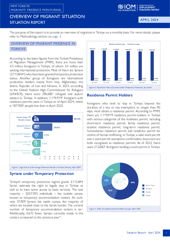
According to the latest figures from the Turkish Presidency of Migration Management (PMM), there are more than 4.5 million foreigners in Türkiye, of whom 3.4 million are seeking international protection. Most of them are Syrians (3,115,8441) who have been granted temporary protection status. Another group of foreigners are international protection holders mainly from Iraq, Afghanistan, the Islamic Republic of Iran and Ukraine.
In 2023, according to the United Nations High Commissioner for Refugees (UNHCR), there were 296,6852 refugees and asylum seekers in Türkiye. In addition, 1,119,9193 foreigners with residence permits were in Türkiye as of April 2024, which is 187,9284 people less than in April 2023.
Jun 16 2024
- Registration
- Mobility Tracking
- Event Tracking
Between 10 and 16 June 2024, a total of 3,013 new arrivals were recorded at locations in Adamawa, Borno, and Yobe states. The new arrivals were recorded at locations in Askira/Uba, Bama, Gwoza, Kaga, Mafa, and Ngala Local Government Areas (LGAs) of the most conflict-affected Borno State, in Demsa, Fufore, Girei, Gombi, Hong, Lamurde, Madagali, Maiha, Mayo Belwa, Michika, Mubi South, Numan, Song, Yola North and Yola South LGAs of Adamawa State and in Bade, Damaturu, Geidam, Potiskum, Tarmua and Yunusari LGAs of Yobe State.
ETT assessments identified the following movement triggers: fear of attack (1,176 individuals or 39%), military operations (576 individuals or 19%), poor living conditions (507 individuals or 17%), improved security (390 individuals or 13%), family re-unification (194 individuals or 6%) and seasonal farming (170 individuals or 6%).
- Mobility Tracking
- Event Tracking
Jun 22 2024
From 1 January to 22 June 2024, IOM Yemen DTM tracked 1,564 households (HH) (9,384 Individuals) who experienced displacement at least once.
Between 16 and 22 June 2024, IOM Yemen DTM tracked 7 households (42 individuals) displaced at least once. The majority of people moved into/within the following governorates and districts:
- Ma’rib (7 HHs) – Marib City (4 HHs), Marib (3 HHs) districts. Most displacements in the governorate originated from Al Hodeidah and Dhamar.
The majority of people moved from the following governorates and districts:
- Al Hodeidah (2 HHs) – At Tuhayta (1 HHs), Ad Durayhimi (1 HHs) districts.
- Dhamar (2 HHs) – Otmah (2 HHs) district.
- Ta’iz (1 HH) – Al Qahirah (1 HHs) district.
Population Groups
IDPs
Returnee (Previously Internally Displaced)
Survey Methodology
Unit of Analysis Or Observation
Admin Area 2
Type of Survey or Assessment
Household
Key Informant
Keywords
Geographical Scope Partial Coverage
Administrative boundaries with available data
The current dataset covers the following administrative boundaries
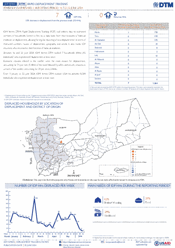
Jun 22 2024
- Mobility Tracking
- Event Tracking
IOM Yemen DTM’s Rapid Displacement Tracking (RDT) tool collects data on estimated numbers of households forced to flee on a daily basis from their locations of origin or displacement, allowing for regular reporting of new displacements in terms of estimated numbers, geography, and needs. It also tracks returnees who returned to their location of origin.
From 1 January to 22 June 2024, IOM Yemen DTM tracked 1,564 households (HH) (9,384 Individuals) who experienced displacement at least once.
Between 16 and 22 June 2024, IOM Yemen DTM tracked 7 households (42 individuals) displaced at least once. The majority of people moved into/within the following governorates and districts:
- Ma’rib (7 HHs) – Marib City (4 HHs), Marib (3 HHs) districts. Most displacements in the governorate originated from Al Hodeidah and Dhamar.
The majority of people moved from the following governorates and districts:
- Al Hodeidah (2 HHs) – At Tuhayta (1 HHs), Ad Durayhimi (1 HHs) districts.
- Dhamar (2 HHs) – Otmah (2 HHs) district.
- Ta’iz (1 HH) – Al Qahirah (1 HHs) district.
May 31 2024
- Survey
- Mobility Tracking
- Event Tracking
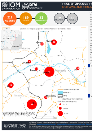
Conflicts between farmers and herders in North-East Nigeria and other Sahel regions are driven by a combination of environmental and demographic factors, including desertification, climate change impacts, and low rainfall which reduces the availability of suitable land for farming and transhumance activities. Rapid population growth further exacerbates these issues by increasing the demand for food, shelter, and security for both humans and livestock. This heightened competition for scarce natural resources often leads to incidents like farming on cattle routes, crop destruction, farm damage, and water pollution, which often escalate into violent confrontations between farming and herding communities.
The Transhumance Tracking Tool (TTT), a component of IOM's Displacement Tracking Matrix (DTM with the support of community key informants) operationalized the Early Warning System in nine selected Local Government Areas (LGAs) in Adamawa and Taraba states. This system collects alerts related to farmer-herder conflicts.Of the 212 alerts recorded in May, 180 alerts (85%) were event-related, while 32 (15%) were related to movements. In Demsa, Lamurde, Girei, Shelleng, and Numan LGAs in Adamawa state, all instances of alerts were event-related. In Mayo-Belwa LGA, 92 per cent were event-related and 8 per cent were movement-related. Also, Guyuk LGA reported 17 per cent event-related alerts and 83 per cent movement-related. In Taraba state, Zing and Lau LGAs reported 83 per cent and 55 per cent event-related alerts, and 17 per cent and 45 per cent movement-related alerts, respectively. Disaggregated ward-level data indicates that Zing ward in Zing LGA in Taraba state and Kodompti ward in Numan LGA of Adamawa state reported the highest percentage of events, 8 and 7 per cent of the total alerts respectively.
- Mobility Tracking
- Event Tracking
Jun 15 2024
From 1 January to 15 June 2024, IOM Yemen DTM tracked 1,557 households (HH) (9,342 Individuals) who experienced displacement at least once.
Between 9 and 15 June 2024, IOM Yemen DTM tracked 15 households (90 individuals) displaced at least once. The majority of people moved into/within the following governorates and districts:
- Ma’rib (15 HHs) – Ma’rib (10 HHs), Ma’rib City (4 HHs), Harib (1 HH) districts. Most displacements in the governorate originated from Al Hodeidah and Hajjah.
The majority of people moved from the following governorates and districts:
- Al Hodeidah (10 HHs) – Hays (3 HHs), Az Zaydiah (2 HHs), Al Mansuriyah (1 HH) districts.
- Hajjah (2 HHs) – Aflah Ash Sham (1 HH), Harad (1 HH) districts.
- Sana’a (1 HH) – Arhab (1 HH) district.
Population Groups
IDPs
Survey Methodology
Unit of Analysis Or Observation
Admin Area 2
Type of Survey or Assessment
Household
Key Informant
Keywords
Geographical Scope Partial Coverage
Administrative boundaries with available data
The current dataset covers the following administrative boundaries
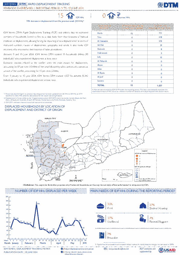
Jun 15 2024
- Mobility Tracking
- Event Tracking
IOM Yemen DTM’s Rapid Displacement Tracking (RDT) tool collects data on estimated numbers of households forced to flee on a daily basis from their locations of origin or displacement, allowing for regular reporting of new displacements in terms of estimated numbers, geography, and needs. It also tracks returnees who returned to their location of origin.
From 1 January to 15 June 2024, IOM Yemen DTM tracked 1,557 households (HH) (9,342 Individuals) who experienced displacement at least once.
Between 9 and 15 June 2024, IOM Yemen DTM tracked 15 households (90 individuals) displaced at least once. The majority of people moved into/within the following governorates and districts:
- Ma’rib (15 HHs) – Ma’rib (10 HHs), Ma’rib City (4 HHs), Harib (1 HH) districts. Most displacements in the governorate originated from Al Hodeidah and Hajjah.
The majority of people moved from the following governorates and districts:
- Al Hodeidah (10 HHs) – Hays (3 HHs), Az Zaydiah (2 HHs), Al Mansuriyah (1 HH) districts.
- Hajjah (2 HHs) – Aflah Ash Sham (1 HH), Harad (1 HH) districts.
- Sana’a (1 HH) – Arhab (1 HH) district.
IOM identified 12 additional households displaced in the previous reporting period, which covered 02 - 08 June 2024, in the governorates of Al Hodeidah (6 HHs), Ma’rib (4 HHs), Ta’iz (2 HHs). These figures have been added to the cumulative displacement total recorded since the beginning of the year.
- Mobility Tracking
- Baseline Assessment
Jun 11 2024
Since October 8 there has been an increase in cross-border incidents between Israel and Lebanon, resulting in the displacement of people both within the South and elsewhere within the country. Since October 10, the Displacement Tracking Matrix (DTM) has been conducting the daily monitoring of population movements. The objective of the exercise is to inform preparedness and response planning.
Population Groups
IDPs
Returnee (Previously Internally Displaced)
Survey Methodology
Unit of Analysis Or Observation
Admin Area 2
Admin Area 3
Household
Individual
Type of Survey or Assessment
Key Informant
Keywords
Geographical Scope Full Coverage
Administrative boundaries with available data
The current dataset covers the following administrative boundaries

DTM API
Making global IDPs data accessible and reliable
The Displacement Tracking Matrix application programming interface (API) accelerates secure sharing of IDPs’ data, simplifying access to data across users and partners to support action, insight and foresight.