Share

Download

Share

Contact
DTM Nigeria, AllUsersInDTMNigeria@iom.int
Language
English
Location
Nigeria
Period Covered
Oct 28 2022
Nov 01 2022
Activity
  • Other
  • Event Tracking

The rainy season in Nigeria typically occurs annually with the greatest concentration of precipitation between the months of June and September. Many states in Nigeria have been affected by unprecedented heavy rainfalls and floods have devastated various communities. Infrastructure, crops, and shelters have been damaged which led to decimated livelihoods and the displacement of numerous households.
Between 28 October and 1 November 2022, DTM, in collaboration with the National Emergency Management Agency (NEMA), the Plateau State Emergency Management Agency (SEMA) and the Nigerian Red Cross Society (NCRS) identified 42 locations in Plateau State that were affected by the floods and/or received IDPs that are currently displaced as a result of the floods. Through a network of 39 key informants and field focal points, and in close coordination with other humanitarian partners and local authorities on the ground, DTM conducted assessments in these locations to inform the humanitarian community of the main needs, vulnerabilities and mobility intentions of the affected population.

Download

Share

Contact
DTM Nigeria, AllUsersInDTMNigeria@iom.int
Language
English
Location
Nigeria
Period Covered
Oct 28 2022
Nov 01 2022
Activity
  • Other
  • Event Tracking

The rainy season in Nigeria typically occurs annually with the greatest concentration of precipitation between the months of June and September. Many states in Nigeria have been affected by unprecedented heavy rainfalls and floods have devastated various communities. Infrastructure, crops, and shelters have been damaged which led to decimated livelihoods and the displacement of numerous households. Over the past months, climate variability and the release of excess water from the Lagdo dam in northern Cameroon, have worsened the flood situation and has resulted in a renewed situation of widespread displacement across Nigeria.
Between 2 and 8 November 2022, DTM, in collaboration with the National Emergency Management Agency (NEMA), the Borno State Emergency Management Agency (BOSEMA) and the Nigerian Red Cross Society (NCRS) identified 111 locations in Borno State that were affected by the floods and/or received IDPs that are currently displaced as a result of the floods.2 Through a network of 95 key informants and field focal points, and in close coordination with other humanitarian partners and local authorities on ground, DTM conducted assessments in these locations to inform the humanitarian community on the main needs, vulnerabilities and mobility intentions of the affected population

Download

Share

Contact
DTM Yemen, iomyemendtm@iom.int
Language
English
Location
Yemen
Period Covered
Dec 11 2022
Dec 17 2022
Activity
  • Mobility Tracking

IOM Yemen DTM’s Rapid Displacement Tracking (RDT) tool collects data on estimated numbers of households forced to flee on a daily basis from their locations of origin or displacement, allowing for regular reporting of new displacements in terms of estimated numbers, geography, and needs. It also tracks returnees who returned to their location of origin.


From 1 January to 17 December 2022, IOM Yemen DTM tracked 10,006 households (HH) (60,036 Individuals) who experienced displacement at least once.


Between 11 and 17 December 2022, IOM Yemen DTM tracked 109 households (654 individuals) displaced at least once. The majority of people moved into/within the following governorates and districts:


  • Marib (68 HHs) – Marib City (56 HHs), Marib (10 HHs), Harib (2 HHs) districts. Most displacements in the governorate originated from Raymah and Al Hodeidah.
  • Taiz (14 HHs) – Al Qahirah (9 HHs), Al Maafer (4 HHs), Ash Shamayatayn (1 HH) districts.      Most displacements in the governorate were internal.
  • Ad Dali (10 HHs) – Qatabah (8 HHs), Ad Dali (2 HHs) districts. Most displacements in the governorate were internal.


The majority of people moved from the following governorates and districts:   

  • Taiz (31 HHs) – Mawiyah (11 HHs), At Taiziyah (9 HHs), Maqbanah (4 HHs) districts.
  • Al Hodeidah (15 HHs) – Al Marawiah (6 HHs), Hays (3 HHs), As Sukhnah (2 HHs) districts.
  • Raymah (11 HHs) – As Salafiyyah (5 HHs), Al Jafariyyah (3 HHs), Kusmah (2 HHs) districts.
Public Dataset

Share

Contact
DTM Yemen, iomyemendtm@iom.int
Location
Yemen
Activity
  • Mobility Tracking
Period Covered
Dec 11 2022 -
Dec 17 2022
From 1 January to 17 December 2022, IOM Yemen DTM tracked 10,006 households (HH) (60,036 Individuals) who experienced displacement at least once.

Between 11 and 17 December 2022, IOM Yemen DTM tracked 109 households (654 individuals) displaced at least once. The majority of people moved into/within the following governorates and districts:

  • Marib (68 HHs) – Marib City (56 HHs), Marib (10 HHs), Harib (2 HHs) districts. Most displacements in the governorate originated from Raymah and Al Hodeidah.
  • Taiz (14 HHs) – Al Qahirah (9 HHs), Al Maafer (4 HHs), Ash Shamayatayn (1 HH) districts. Most displacements in the governorate were internal.
  • Ad Dali (10 HHs) – Qatabah (8 HHs), Ad Dali (2 HHs) districts. Most displacements in the governorate were internal.
The majority of people moved from the following governorates and districts:

  • Taiz (31 HHs) – Mawiyah (11 HHs), At Taiziyah (9 HHs), Maqbanah (4 HHs) districts.
  • Al Hodeidah (15 HHs) – Al Marawiah (6 HHs), Hays (3 HHs), As Sukhnah (2 HHs) districts.
  • Raymah (11 HHs) – As Salafiyyah (5 HHs), Al Jafariyyah (3 HHs), Kusmah (2 HHs) districts.
Population Groups

Survey Methodology

Unit of Analysis Or Observation

Type of Survey or Assessment

Keywords

Geographical Scope

Administrative boundaries with available data

The current dataset covers the following administrative boundaries

Public Dataset

Share

Contact
DTM Yemen, DTMYemen@iom.int
Location
Yemen
Activity
  • Mobility Tracking
  • Baseline Assessment
Period Covered
Oct 01 2022 -
Nov 30 2022
This summary presents the findings of the first round of Area Assessment (Mobility Tracking) undertaken by IOM’s Displacement Tracking Matrix to establish a new baseline on the number of Internally Displaced Persons (IDPs), IDP returnees and migrants in Yemen. Findings are currently limited to the country’s south controlled by the internationally recognized government (IRG). Data was collected by 153 enumerators through an extensive network of Key Informants (KIs) within the operational area. In the Yemen context, the practice for field teams is to select KI representatives of both the host and target communities while adhering to the humanitarian principles of humanity, neutrality, impartiality and operational independence. This ensures that the selected KIs are the most relevant and appropriate individuals to ensure the successful implementation of the exercise. This round 3,633 KIs were interviewed to collect the data, of whom seven per cent or 270 were female and 93 per cent or 3,363 were male. Among the main outputs of the Sub-Area Assessment, is a list of locations where IDPs, returnees and / or migrants are present that can be used to inform more detailed assessments at the location level, including the annual Multi-Cluster Location Assessment (MCLA). DTM field staff, along with KIs, use the Sub-Area Assessment tool to capture locations, which are matched to the identified locations in the OCHA Common Operational Dataset (P-Codes). Using a standardized and structured approach to the selection of KIs is a key step to ensuring that data collected in the Sub-Area Assessment is comprehensive and comparable across the different teams. The Sub-Area Assessment tool is used to verify and update the baseline information in regular intervals (rounds). Deployed DTM staff, called enumerators, are in regular communication with their KI network throughout each month and work continuously to maintain and expand this network to further triangulate the displacement statistics collected. The forms and definitions used can be accessed here. Please note that findings represent the results of a pilot round in this new format. Findings for Aden Governorate are not supported by Yemen’s Central Statistical Organization (CSO) and the Executive Unit for IDP Camps Management (ExU) for this round but will be further verified in the subsequent round of the Area Assessment in 2023. The ExU maintains that the current number of IDPs living in Aden stands at 145,857 individuals.
Population Groups

Survey Methodology

Unit of Analysis Or Observation

Type of Survey or Assessment

Keywords

Geographical Scope

Administrative boundaries with available data

The current dataset covers the following administrative boundaries

Download

Share

Contact
DTM Mali, DTMMali@iom.int
Language
French
Location
Mali
Period Covered
Jul 01 2022
Sep 30 2022
Activity
  • Survey
  • Flow Monitoring Survey
  • Flow Monitoring

Ce rapport met en exergue les principaux résultats issus de l’enregistrement de flux de migrants et des enquêtes individuelles effectués par la DTM auprès des migrants transitant aux différents points de suivi de flux (FMP) du Mali au cours du troisième trimestre de l’année 2022.

Les différents résultats témoignent du fait que le Mali soit l’une des principales routes empruntées par les migrants en Afrique de l’Ouest. En effet, la diversité des nationalités observées (23 nationalités), des routes empruntées, des pays de provenance et de destination, démontrent la place prépondérante qu’occupe le Mali dans les mobilités en Afrique de l’Ouest et du Centre.

Les problématiques de la traite des personnes, du trafic illicite de migrants, de vulnérabilités, ainsi que l’insécurité observée de jour en jour sur les routes migratoires, auxquelles sont exposées les migrants restent des facteurs sur lesquels peu d’information sont fournies. La forme d’exploitation observée au cours de ce trimestre était le travail forcé des migrants sur la route migratoire.

Download

Share

Contact
RO Dakar, RODakar-DataResearch@iom.int
Language
English
Location
Period Covered
Jan 01 2022
Sep 30 2022
Activity
  • Other
  • Flow Monitoring

This document presents key figures relating to maritime migration from the coasts of West Africa to Mauritania, Morocco and the Canary Islands (Spain). This route, already active in 2006, has seen exponential growth in movements since its 'reactivation' in 2019. The risks, deaths and disappearances following shipwrecks are also on the rise along the West African Atlantic Route (WAAR).

Between January and September 2022, 12,506 individuals reached the Canary Islands irregularly after crossing by boat from the coasts of West Africa, a decrease of 5 per cent i.e. 612 people per compared to 2021 (13,118)(3). This is the first time since the increase in crossings was first recorded in 2019 that this number has shrunk. Nevertheless, the risks and hazards along the West African Atlantic Route remain, and 32 shipwrecks were recorded along that route in 2022, leading to the death or disappearance of 350 migrants.

Download

Share

Contact
DTMMozambique@iom.int
Language
English
Location
Mozambique
Period Covered
Dec 07 2022
Dec 13 2022
Activity
  • Mobility Tracking
  • Event Tracking

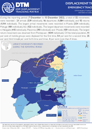
During the reporting period (7 December to 13 December 2022), a total of 52 movements were recorded - 21 arrivals (539 individuals), 16 departures (1,084 individuals), and 15 returns (1,114 individuals). The largest arrival movements were recorded in Mueda (254 individuals), Metuge (181 individuals), Ibo (122 individuals).. The largest departure movements were recorded in Nangade (415 individuals), Macomia (393 individuals) and Mueda (159 individuals). The largest return movement was observed from Montepuez (1041 individuals). Of the total population, 11 per cent of mobile groups were displaced for the first time, 54 per cent for a second time, 25 per cent third time,6 per cent forth time and times. 4 per cent more than 4 times.