Government of Japan
Global
No

This report details the site profiles as determined by Multi-Sectoral Location Assessments (MSLA). A summary overview can be accessed here.
Cyclone Freddy made landfall in Malawi’s Southern Region on 12 March 2023, bringing torrential rainfall, and causing devasting floods and mudslides in Southern Malawi. Assessments are still ongoing, led by the Department of Disaster Management Affairs (DoDMA) but critical infrastructure (roads, houses and hospitals) have been damaged or destroyed. As of 20 March 2023, DoDMA estimates over 508,000 people have been displaced across Nsanje, Chikwawa, Phalombe, Mulanje, Blantyre, Thyolo, Chiradzulu, Blantyre City, Mangochi, Machinga and Balaka districts. An estimated 534 evacuation centers/Internally Displaced People (IDP) sites have been established with over 70 per cent of the IDPs being hosted in public buildings such as schools and churches. The Government of Malawi (GoM) announced a state of disaster in 14 districts on 13 March in response to the floods and landslides, and rescue teams were deployed to the affected areas to provide humanitarian assistance to those most affected. IOM deployed teams on 3 April to conduct a Multi-Sectoral Location Assessment (MSLA) at camp/collective sites level to assist the Government and partners with their response efforts. The first update of the report covers the 168 sites assessed from 31 March - 27 April and provides a snapshot of the current number of displaced households and persons residing in the worst affected three districts (Nsanje, Chikwawa and Blantyre). The assessments also provide an overview of the types of IDP sites, NFI needs, intentions, services provided and other key information.
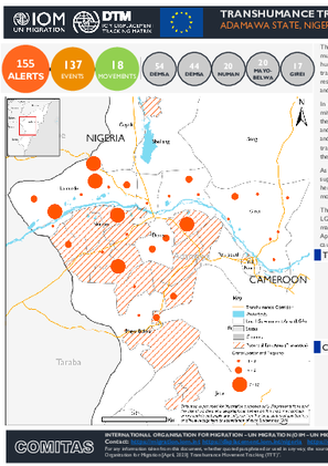
As a component of the IOM's Displacement Tracking Matrix (DTM), the Transhumance Tracking Tools supported by a network of community key informants, collected information on events relating to herders and farmers conflicts. The triangulated alerts comprises of 137 (88%) events and 18 (12%) movement alerts across 31 wards in the 5 LGAs.
The largest number of alerts occurred in Demsa LGA (35%) followed by Lamurde LGA (28%), Numan LGA (13%), Mayo-belwa (13%) and Girei (11%). The disaggregated alerts show the highest reports were made in Kodompti (9%) and Demsa (8%) wards located respectively in Numan and Demsa LGAs. Approximately 2 per cent of events alerts resulted in population displacement, while 27 per cent lead to causality or injuries.
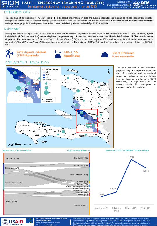
The objective of the Emergency Tracking Tool (ETT) is to collect information on large and sudden population movements as well as security and climatic emergencies. Information is collected through phone interviews with key informants and direct observation. This dashboard presents information on important population displacements that occurred during the month of April 2023 in Haiti.
During this month, several violent events led to massive population displacements in the Western district in Haiti. In total, 8,919 individuals (2,261 households) were displaced, representing 19 percent less compared to March 2023 when 11,036 people were displaced. The municipalities of Cabaret (42%) and Port-au-Prince (27%) were the main origins of IDPs. And locations located in the municipalities of Arcahaie (34%) and Port-au-Prince (24%) were their main destinations. The majority of IDPs (76%) took refuge in host communities and the rest (24%) in sites.
Le suivi des flux de populations est un travail de collecte des données qui vise à identifier des zones sujettes aux migrations internes et transfrontalières et à mettre en lumière les caractéristiques et les parcours des personnes passant par ces zones. Il est mis en œuvre en étroite collaboration avec les autorités et des partenaires nationaux et locaux, à travers deux outils: l’enregistrement des flux (Flow Monitoring Registry, FMR) et les enquêtes individuelles (Flow Monitoring Survey, FMS).
L'outil récolte des données clés sur l’amplitude des flux migratoires, les profils des voyageurs ainsi que leurs parcours et intentions, afin de fournir une meilleure compréhension des flux migratoires dans la région et contribuer à l’élaboration des politiques migratoires basées sur des évidences.
À cet effet, plusieurs points de suivi des flux de population (Flow Monitoring Point, FMP) sont installés dans des zones de transit importantes. Durant le quatrième trimestre de 2022, avec l’implication de l’Institut National de la Statistique et des Etudes Economiques et Démographiques (INSEED), quatre FMP ont été actifs a Faya, Ounianga Kébir, Gouro et Zouarké, respectivement situés dans les provinces du Borkou, de l’Ennedi Ouest et du Tibesti, au nord du Tchad. Ce rapport présente les données clés collectées entre octobre et décembre 2022 au niveau de ces quatre FMP. Le rapport est subdivisé en deux sections:
Une section présentant les données obtenues lors de l’enregistrement des flux (FMR).
Une autre section présentant les résultats des enquêtes individuelles effectuées auprès des voyageurs (FMS).

Ce tableau de bord présente les résultats d'évaluations menées entre le 29 Novembre 2022 – 9 Janvier 2023 dans 245 lieux de déplacement. Une légère augmentation du nombre des personnes déplacées, a été observé durant ce round 19 par rapport au round précédent (+6%). Ceci s’explique principalement par les déplacements dus aux inondations et à l'insécurité durant cette période. C’est à noter que ces évaluations prennent en compte les chiffres issus des enregistrements biométriques menés par l’Institut national des statistiques et des études économiques et démographiques (INSEED), la Commission Nationale d’Accueil de Réinsertion des Réfugiés et des Rapatriées (CNARR), le Programme alimentaire mondial (PAM) et l’Organisation internationale pour les migrations (OIM), dans 11 localités en décembre 2022 et janvier 2023, qui a contribué à une baisse de 5 pour cent dans la sous-préfecture de Baga-Sola. Comme pour le round précédent de collecte de données, le round 19 a été réalisé en partenariat avec la CNARR et l’association pour l’Action Humanitaire et le Développement Durable (ACHDR), en appliquant une méthodologie de vérification ainsi que le renforcement de l'observation physique et de la sensibilisation des informateurs clés et les autorités administratifs pour éviter les doubles comptages ou la surestimation des informateurs clés.
Unit of Analysis Or Observation
Type of Survey or Assessment
Administrative boundaries with available data
The current dataset covers the following administrative boundaries
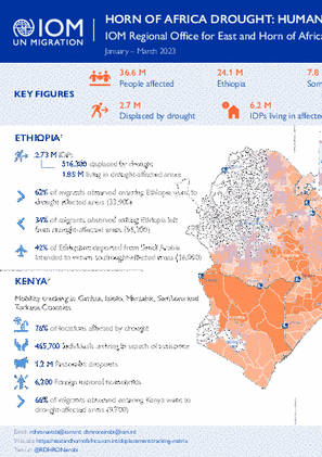
This snapshot provides an overview of the impact of drought on human mobility in the region, with a focus on Djibouti, Ethiopia, Kenya and Somalia.
Unit of Analysis Or Observation
Type of Survey or Assessment
Administrative boundaries with available data
The current dataset covers the following administrative boundaries

DTM API
Making global IDPs data accessible and reliable
The Displacement Tracking Matrix application programming interface (API) accelerates secure sharing of IDPs’ data, simplifying access to data across users and partners to support action, insight and foresight.