East and the Horn of Africa
DTM East and the Horn of Africa
DTM Operations in the region
- Active DTM operation
- Past DTM operation
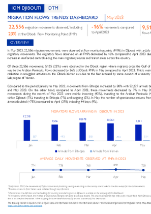
En mai 2023, 22 556 mouvements migratoires ont été observés aux points de suivi des flux (FMP) à Djibouti soit une moyenne journalière de 728 mouvements migratoires.
In May 2023, 22,556 migratory movements were observed at flow monitoring points (FMPs) in Djibouti with a daily average of 728 migratory movements.
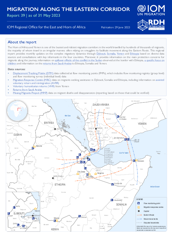
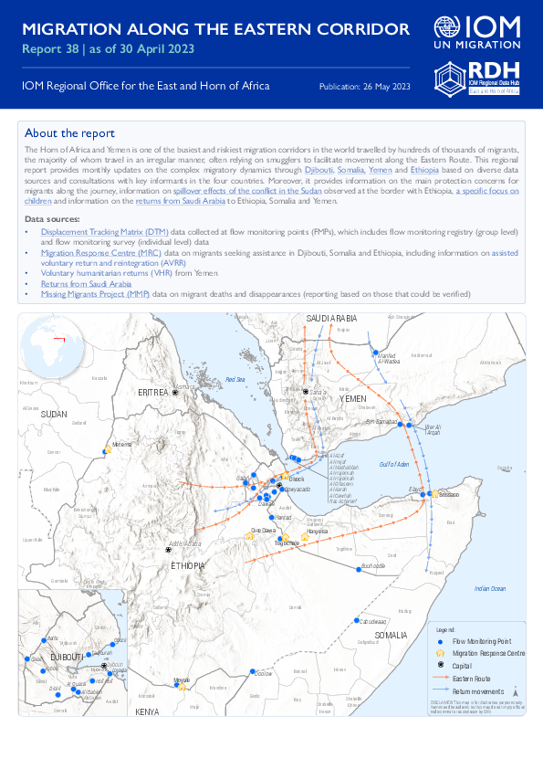
The Horn of Africa and Yemen is one of the busiest and riskiest migration corridors in the world travelled by hundreds of thousands of migrants, the majority of whom travel in an irregular manner, often relying on smugglers to facilitate movement along the Eastern Route.
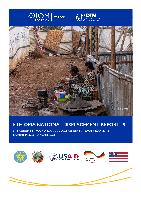
Between August and September 2022, the International Organization for Migration (IOM), through its Displacement Tracking Matrix (DTM) methodology, deployed the Site Assessment (SA) and Village Assessment Survey (VAS) tools to assess the mobility, needs and vulnerabilities of Internally Disp

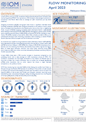
In April 2023, a total of 41,787 movements were observed across five of Ethiopia's flow monitoring points (FMPs). This represents a 14% increase in daily average movements in comparison with March 2023 when an average of 1,221 movements per day were observed.
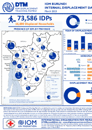
DTM has identified 73,586 internally displaced persons (IDPs) in 16,690 households. Almost all displacements were due to natural disasters (89%), while 11% were due to other reasons.
There are 370,390 individuals currently displaced by drought in Gedo region. Since round 65 an estimated 3,726 IDPs arrived at the assessed settlements.

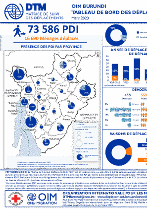
La DTM a identifié 73 586 personnes déplacées à l'intérieur du pays (PDI) dans 16 690 ménages. Presque tous les déplacements étaient dus à des catastrophes naturelles (89 %), tandis que 11 % étaient dus à d'autres raisons.
There are 366,819 individuals currently displaced by drought in Gedo region. Since round 64 an estimated 4,077 IDPs arrived at the assessed settlements.

In order to capture the displacement and return dynamics in Ethiopia, DTM Ethiopia's National Displacement Report combines findings from its Site Assessment (SA) in Section 1 and findings from the Village Assessment Survey (VAS) in Section 2.
En mai 2020, le Burundi a organisé ses premières élections générales depuis 2015. Depuis l'inauguration du nouveau gouvernement en juin 2020, le pays a connu des améliorations notables en termes de sécurité et de situation politique et socio-économique.

The overall objective of the 2022 humanitarian Inter-Sectoral Needs Assessment (ISNA) is to collect and analyze data on household needs and vulnerabilities, displacement and migration history, shelter and non-food items (SNFI), water, sanitation and hygiene (WASH), health, education, protection -

In May 2020, Burundi held its first general elections since 2015. Since the inauguration of the new government in June 2020, the country has seen significant improvements in security, political and socio-economic conditions.
In January 2023, 58,629 movements were tracked at nine Flow Monitoring Points (FMPs) at the Ugandan border with Kenya, the Democratic Republic of Congo, the United Republic of Tanzania, Rwanda and South Sudan.

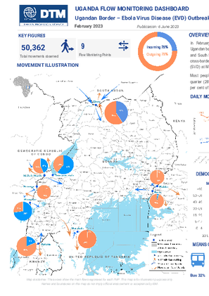
In February 2023, 50,362 movements were tracked at nine Flow Monitoring Points (FMPs) at the Ugandan border with Kenya, the Democratic Republic of Congo, the United Republic of Tanzania, Rwanda and South Sudan.
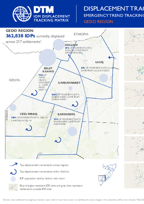
There are 362,838 individuals currently displaced by drought in Gedo region.
As per March 2023 population count findings, the Bentiu Town Sites (A, B, C, D, and E) population stands at 71,424 individuals / 9,976 households (on average 7 individuals per households). This represents a twelve per cent decrease (8,402 individuals/887 households) compared to January 2023.

The Horn of Africa and Yemen is one of the busiest and riskiest migration corridors in the world travelled by hundreds of thousands of migrants, the majority of whom travel in an irregular manner, often relying on smugglers to facilitate movement along the Eastern Route.
As per March 2023 population count findings, the Bentiu IDP camp population stands at 102,436 individuals (17,440 households) in 12,038 inhabited shelters (on average of 6 individuals per shelter). This represents a two per cent increase compared to January 2023.

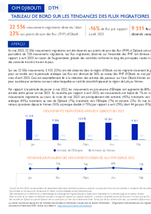
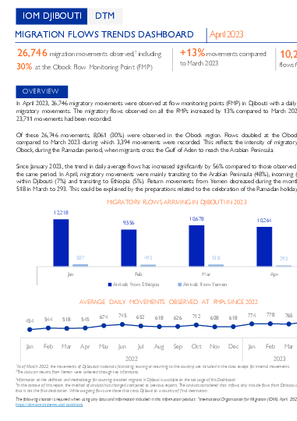
En avril 2023, 26 746 mouvements migratoires ont été observés aux points de suivi des flux (FMP) à Djibouti avec une moyenne quotidienne de 892 mouvements migratoires.

In April 2023, 26,746 migratory movements were observed at flow monitoring points (FMP) in Djibouti with a daily average of 892 migratory movements. The migratory flows observed on all the FMPs increased by 13% compared to March 2023 during which 23,711 movements had been recorded.
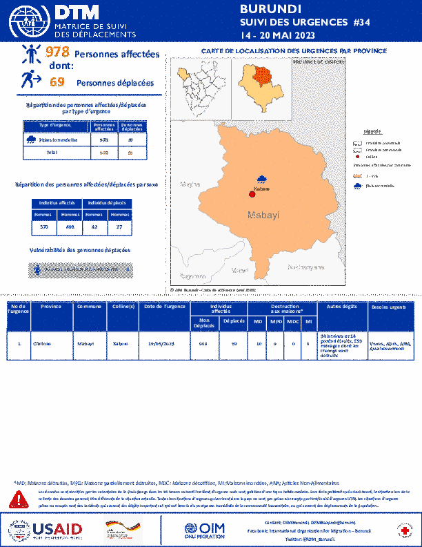
La DTM a identifié 978 personnes affectées dont 69 personnes déplacées par les pluies torrentielles et les vents violents dans le province de Cibitoke.
There are 358,620 individuals currently displaced by drought in Gedo region.

There are 355,360 individuals currently displaced by drought in Gedo region.
Ethiopia - Site Assessment Round 23
Dec 10 2020
A site assessment is a sub-component of mobility tracking. It aims to collect data on population presence, living conditions and needs in a particular displacement site or community. *The displacement figures for Tigray region are subject to verification from the Regional Disaster Risk Management…
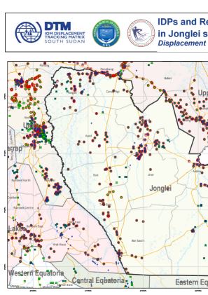
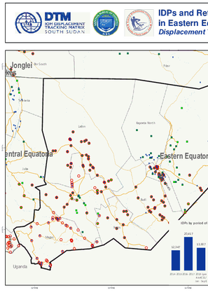
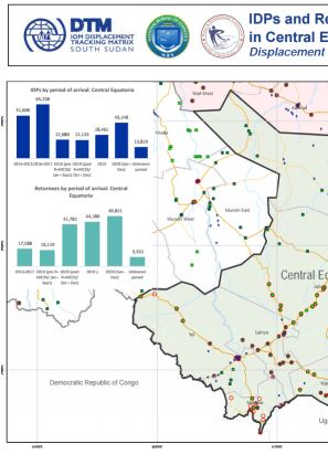
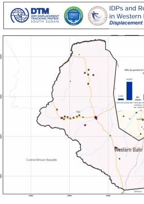
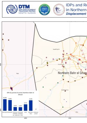
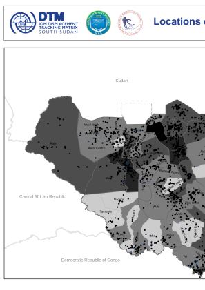
South Sudan - Baseline Locations Round 9
Dec 01 2020
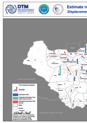
A baseline assessment is a sub-component of mobility tracking. It aims to collect data on IDP, migrant or returnee population presence in a defined administrative area of the country. During Round 9 DTM covered 2,854 locations.
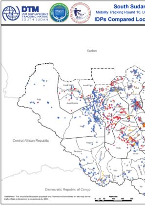
South Sudan — Flow Monitoring Registry — August 2020
Oct 27 2020
Flow monitoring aims to derive quantitative estimates of the flow of individuals through specific locations, to collect information about the profile, intentions and mobility history of the people moving, and to quantify highly mobile populations by providing a picture of complex mobility dynamics.
Burundi — Baseline Assessment — Round 55
Oct 26 2020
A baseline assessment is a sub-component of mobility tracking. It aims to collect data on IDP, migrant or returnee population presence in a defined administrative area of the country.
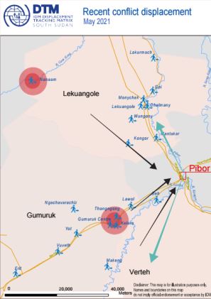
South Sudan - Event Tracking (January - June 2020)
Oct 25 2020
<p>IOM DTM employs Event Tracking as a more rapid and localized assessment tool complementing overall efforts to report on IDP and returnee figures nationally. IOM teams access IDP/returnee locations and consult local key informants including community representatives, local authorities or…
Uganda — Baseline Assessment — May 2020 — Round 1
Oct 19 2020
A baseline assessment is a sub-component of mobility tracking. It aims to collect data on IDP, migrant or returnee population presence in a defined administrative area of the country.
Ethiopia - Site Assessment Round 22
Sep 25 2020
A site assessment is a sub-component of mobility tracking. It aims to collect data on population presence, living conditions and needs in a particular displacement site or community. A total of 1,297 IDPs sites were assessed this round.
Burundi — Baseline Assessment — Round 54
Sep 23 2020
A baseline assessment is a sub-component of mobility tracking. It aims to collect data on IDP, migrant or returnee population presence in a defined administrative area of the country.
Somalia - Baseline Assessment (B2) - Pilot Round 0
Sep 15 2020
A baseline assessment is a sub-component of mobility tracking. It aims to collect data on IDP, migrant or returnee population presence in a defined administrative area of the country.
South Sudan — Flow Monitoring Registry — July 2020
Sep 01 2020
Flow monitoring aims to derive quantitative estimates of the flow of individuals through specific locations and to collect information about the profile, intentions and vulnerabilities of the people moving. It aims to quantify highly mobile populations by providing a picture of complex mobility…
South Sudan — COVID-19 Mobility Update 15 (27 July - 9 August 2020)
Aug 25 2020
Dataset for COVID-19 Mobility Update 15
South Sudan - Village Assessment Survey - Wau, Rubkona, Bor South, Aweil Centre, Malakal, Magwi and Torit, Boma Multisectoral Service Availability (August 2019 - March 2020)
Aug 25 2020
Since the beginning of the exercise in the last quarter of 2019, IOM’s Displacement Tracking Matrix (DTM) conducted Village Assessment Survey (VAS) across 7 counties covering 182 out of 219 bomas (achieving 83 per cent coverage) in Wau, Rubkona, Bor South, Torit, Magwi, Aweil Centre and Malakal…
South Sudan - Village Assessment Survey - Wau, Rubkona, Bor South, Aweil Centre, Malakal, Magwi and Torit, FIS (August 2019 - March 2020)
Aug 25 2020
Since the beginning of the exercise in the last quarter of 2019, IOM’s Displacement Tracking Matrix (DTM) conducted Village Assessment Survey (VAS) across 7 counties covering 182 out of 219 bomas (achieving 83 per cent coverage) in Wau, Rubkona, Bor South, Torit, Magwi, Aweil Centre and Malakal…
South Sudan - Village Assessment Survey - Wau, Rubkona, Bor South, Aweil Centre, Malakal, Magwi and Torit, Education Facility Assessment (August 2019 - March 2020)
Aug 25 2020
Since the beginning of the exercise in the last quarter of 2019, IOM’s Displacement Tracking Matrix (DTM) conducted Village Assessment Survey (VAS) across 7 counties covering 182 out of 219 bomas (achieving 83 per cent coverage) in Wau, Rubkona, Bor South, Torit, Magwi, Aweil Centre and Malakal…
South Sudan - Village Assessment Survey - Wau, Rubkona, Bor South, Aweil Centre, Malakal, Magwi and Torit, Health Facility Assessment (August 2019 - March 2020)
Aug 25 2020
Since the beginning of the exercise in the last quarter of 2019, IOM’s Displacement Tracking Matrix (DTM) conducted Village Assessment Survey (VAS) across 7 counties covering 182 out of 219 bomas (achieving 83 per cent coverage) in Wau, Rubkona, Bor South, Torit, Magwi, Aweil Centre and Malakal…
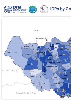
South Sudan — Site Assessment - Round 8
Aug 03 2020
A site assessment is a sub-component of mobility tracking. It aims to collect data on population presence, living conditions and needs in a particular displacement site or community.
South Sudan — Flow Monitoring Registry — June 2020
Aug 03 2020
Flow monitoring aims to derive quantitative estimates of the flow of individuals through specific locations and to collect information about the profile, intentions and needs of the people moving and to quantify highly mobile populations by providing a picture of complex mobility dynamics.
South Sudan — COVID-19 Mobility Update 13 (29 June - 12 July 2020)
Aug 01 2020
Dataset for COVID-19 Mobility Update 13
Burundi — Baseline Assessment — Round 53
Jul 27 2020
A baseline assessment is a sub-component of mobility tracking. It aims to collect data on IDP, migrant or returnee population presence in a defined administrative area of the country.

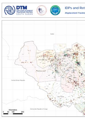


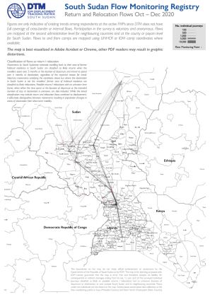
This map shows a picture of return and relocation flows tracked by DTM's Flow Monitoring Registry in South Sudan and between South Sudan and neighbouring countries, based on interviews carried out at 34 Flow Monitoring Points between October and December 2020. Figures are only indicative of existing trends among respondents at the active FMPs since DTM does not have full coverage of cross-border or internal flows. Participation in the survey is voluntary and anonymous.Flows are mapped at the second administrative level for neighbouring countries and at the county or payam level for South Sudan. Flows to and from camps are mapped using UNHCR or IOM camp coordinates where available.The map is best visualized in Adobe Acrobat or Chrome, other PDF readers may result in graphic distortions.
This map shows a picture of long / medium term migration flows tracked by DTM's Flow Monitoring Registry in South Sudan and between South Sudan and neighbouring countries, based on interviews carried out at 34 Flow Monitoring Points between October and December 2020. Figures are only indicative of existing trends among respondents at the active FMPs since DTM does not have full coverage of cross-border or internal flows. Participation in the survey is voluntary and anonymous.Flows are mapped at the second administrative level for neighbouring countries and at the county or payam level for South Sudan. Flows to and from camps are mapped using UNHCR or IOM camp coordinates where available.The map is best visualized in Adobe Acrobat or Chrome, other PDF readers may result in graphic distortions.

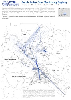
This map shows a picture of the human mobility network tracked by DTM's Flow Monitoring Registry in South Sudan and between South Sudan and neighbouring countries, based on interviews carried out at 34 Flow Monitoring Points between October and December 2020. Figures are only indicative of existing trends among respondents at the active FMPs since DTM does not have full coverage of cross-border or internal flows. Participation in the survey is voluntary and anonymous.Flows are mapped at the second administrative level for neighbouring countries and at the county or payam level for South Sudan. Flows to and from camps are mapped using UNHCR or IOM camp coordinates where available.The map is best visualized in Adobe Acrobat or Chrome, other PDF readers may result in graphic distortions.
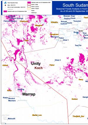
Seasonal Flood Analysis for Koch County in Unity State as of 28 and 29 December 2020.
Seasonal Flood Analysis for Panyijar County in Unity State as of 29 September 2020.


DTM API
Making global IDPs data accessible and reliable
The Displacement Tracking Matrix application programming interface (API) accelerates secure sharing of IDPs’ data, simplifying access to data across users and partners to support action, insight and foresight.