East and the Horn of Africa
DTM East and the Horn of Africa
DTM Operations in the region
- Active DTM operation
- Past DTM operation
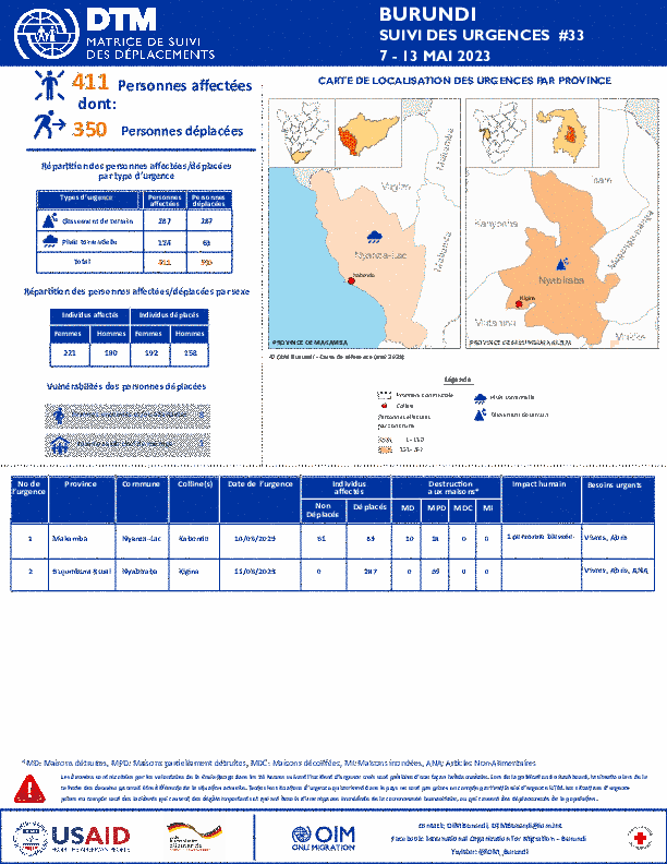
La DTM a identifié 411 personnes affectées dont 350 personnes déplacées par les pluies torrentielles et les glissements de terrain dans les provinces de Makamba et Bujumbura Rural.
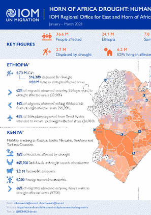
This snapshot provides an overview of the impact of drought on human mobility in the region, with a focus on Djibouti, Ethiopia, Kenya and Somalia.
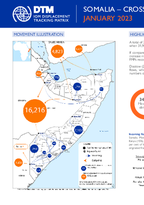
A total of 34,554 movements were observed in January 2023, representing a 8% increase compared to 2022 when 31,960 movements were observed during the same period.
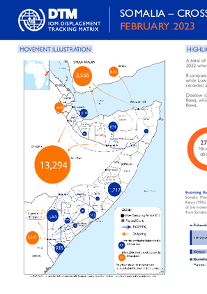
A total of 27,201 movements were observed in February 2023, representing a -5% decrease compared to 2022 when 28,717 movements were observed during the same period.
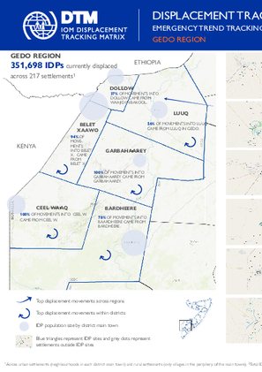
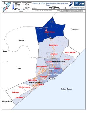
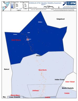
There are 351,698 individuals currently displaced by drought in Gedo region.
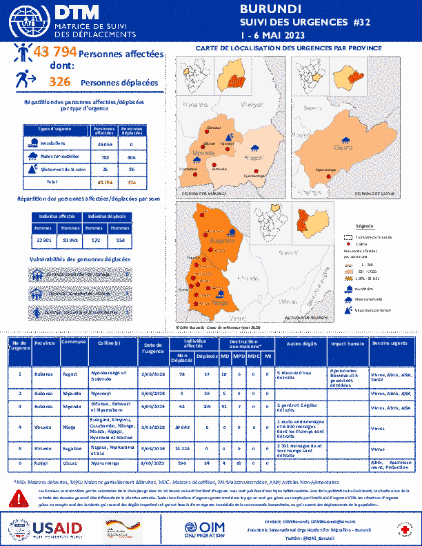
La DTM a identifié 43 794 personnes affectées dont 326 personnes déplacées par les inondations, les pluies torrentielles et les glissements de terrain dans les provinces de Bubanza, Kirundo et Ruyigi.
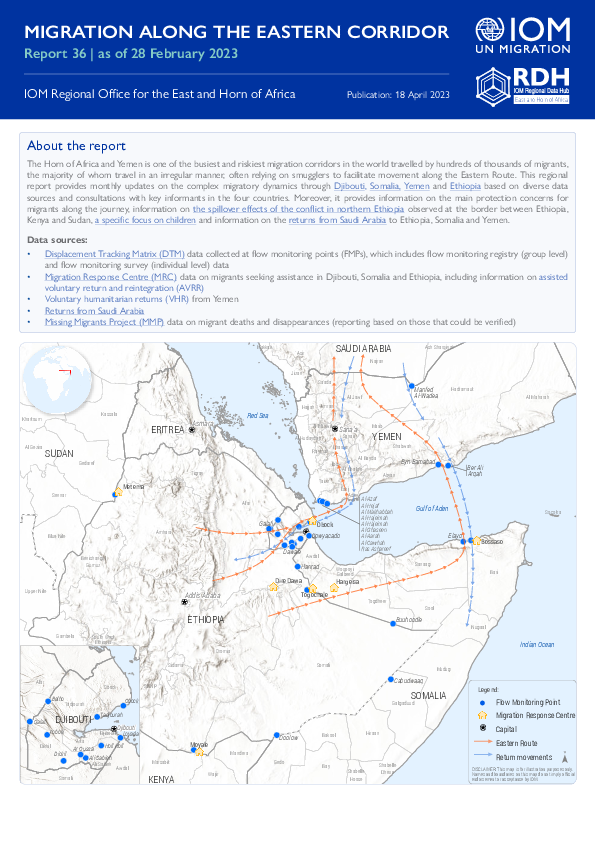
The Horn of Africa and Yemen is one of the busiest and riskiest migration corridors in the world travelled by hundreds of thousands of migrants, the majority of whom travel in an irregular manner, often relying on smugglers to facilitate movement along the Eastern Route.

In March 2023, a total of 37,846 movements were observed across five of Ethiopia's flow monitoring points (FMPs). This represents a 10% increase in daily average movements in comparison with February 2023 when an average of 1,114 movements per day were observed.

Floods, accidents, drought, landslides and heavy winds accompanied by hailstorms were the major hazard events reported in the month of April. The disasters affected a total of 19,311 individuals, representing 3,857 households while 552 individuals from 394 households were interna
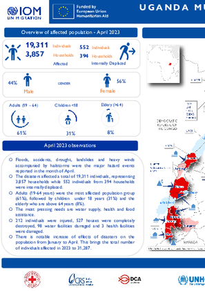
Floods, accidents, drought, landslides and heavy winds accompanied by hailstorms were the major hazard events reported in the month of April. The disasters affected a total of 19,311 individuals, representing 3,857 households while 552 individuals from 394 households were internally displaced.

La DTM a identifié 6 742 personnes affectées dont 327 personnes déplacées par les pluies torrentielles et les vents violents dans les provinces de Cibitoke, Muyinga et Kirundo.

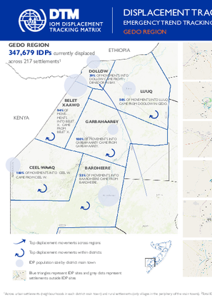
There are 347,679 individuals currently displaced by drought in Gedo region. Since round 59 an estimated 4,985 IDPs arrived at the assessed settlements.
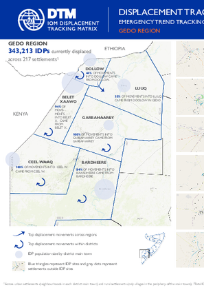
There are 343,213 individuals currently displaced by drought in Gedo region.
La DTM a identifié 805 personnes affectées par les pluies torrentielles et les vents violents dans les provinces de Makamba, Giteha et Cankuzo.

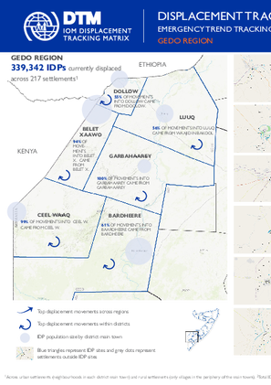
There are 339,342 individuals currently displaced by drought in Gedo region. Since round 57 an estimated 3,437 IDPs arrived at the assessed settlements.
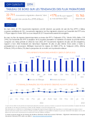
En mars 2023, 23 711 mouvements migratoires ont été observés aux points de suivi des flux (FMP) à Djibouti avec une moyenne quotidienne de 765 mouvements migratoires.
There are 340,375 individuals currently displaced by drought in Gedo region. Since round 56 an estimated 7,598 IDPs arrived at the assessed settlements.

In March 2023, 23,711 migratory movements were observed at flow monitoring points (FMP) in Djibouti with a daily average of 765 migratory movements. The migratory flows observed in all FMPs increased by 17% compared to February 2023 during which 20,237 movements were recorded.

The Horn of Africa and Yemen is one of the busiest and riskiest migration corridors in the world travelled by hundreds of thousands of migrants, the majority of whom travel in an irregular manner, often relying on smugglers to facilitate movement along the Eastern Route.
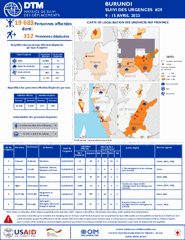
La DTM a identifié 19 683 personnes affectées (3 616 ménages) dont 312 personnes déplacées (57 ménages) par la grêle, les pluies torrentielles et les vents violents dans les provinces de Bubanza, Rumonge, Ngozi, Muyinga et Kirundo.
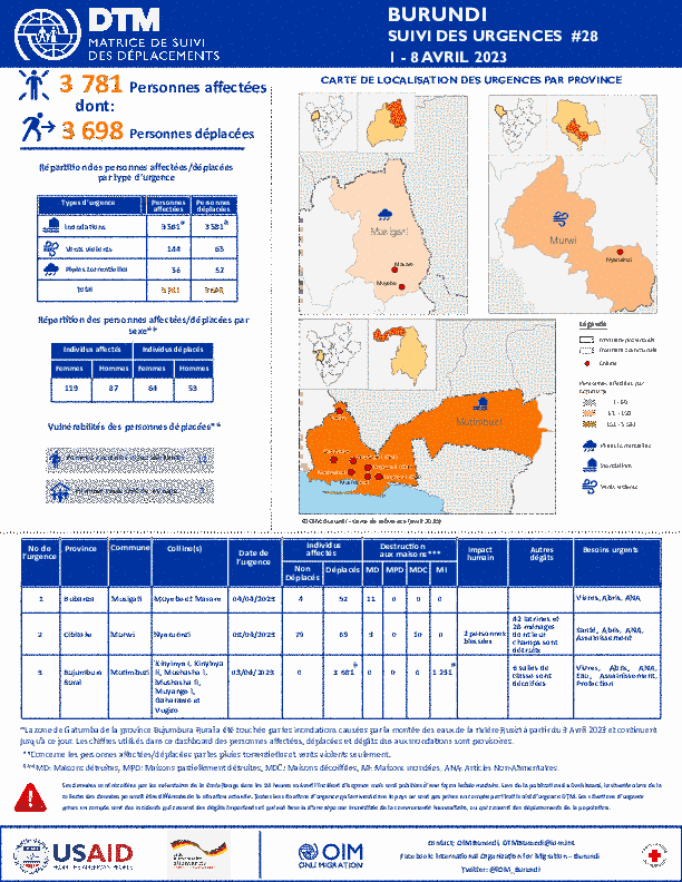
La DTM a identifié 3 781 personnes affectées (1 270 ménages) dont 3 698 personnes déplacées (1 254 ménages) par les inondations, les pluies torrentielles et les vents violents dans les provinces de Bujumbura Rural, Cibitoke et Bubanza.
This Aweil South Village Assessment Survey covers a period from 26 March to 30 April 2021. Notably, it was found that 89% of education facilities are functional, and 72% of water points are functional.

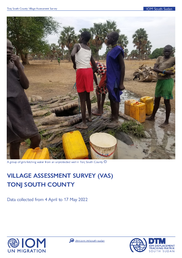
This Tonj South Village Assessment Survey covers a period from 4 April to 17 May 2022. Notably, it was found that 94% of administrative buildings, 90% of religious buildings, and 88% water points are functional.
Samburu County is the tenth largest county in Kenya covering 21,000 square kilometers (km)2, located in the upper Northern region of Kenya and is among the 29 counties identified as ASAL area. The county has three sub-counties with headquarters located at Maralal Town.
South Sudan — Flow Monitoring Registry — May 2020
Jul 15 2020
Flow monitoring aims to derive quantitative estimates of the flow of individuals through specific locations and to collect information about the profile, intentions and vulnerabilities of the people moving. It aims to quantify highly mobile populations by providing a picture of complex mobility…
South Sudan — COVID-19 Mobility Update 12 (15-28 June 2020)
Jul 03 2020
Dataset for COVID-19 Mobility Update 12 (15-28 June 2020)
South Sudan — COVID-19 Mobility Update 11 (1-14 June 2020)
Jun 26 2020
Dataset for COVID-19 Mobility Update 11 (1-14 June 2020)
South Sudan — COVID-19 Mobility Update Week 10 (25-31 May 2020)
Jun 17 2020
Dataset for COVID-19 Mobility Update 10
South Sudan — COVID-19 Mobility Update Week 9 (18-24 May 2020)
Jun 11 2020
Dataset for COVID-19 Mobility Update 9
South Sudan - Round 8 Summaries: Periods of Arrival, Reasons for Displacement, Returnee Shelter Status
Jun 10 2020
The workbook includes summaries on periods of arrival, reasons for displacement and returnee shelter status for DTM mobility tracking round 8 in South Sudan.
South Sudan - Baseline Locations Round 8
Jun 10 2020
The dataset contains mobility tracking round 8 data on 2,747 locations.
Ethiopia — Site Assessment Round 9
Mar 23 2018
A site assessment is a sub-component of mobility tracking. It aims to collect data on population presence, living conditions and needs in a particular displacement site or community.
South Sudan — Flow Monitoring Registry — April 2020
Jun 04 2020
Flow monitoring aims to derive quantitative estimates of the flow of individuals through specific locations and to collect information about the profile, intentions and vulnerabilities of the people moving. It aims to quantify highly mobile populations by providing a picture of complex mobility…
Burundi — Baseline Assessment — Round 52
Jun 03 2020
A baseline assessment is a sub-component of mobility tracking. It aims to collect data on IDP, migrant or returnee population presence in a defined administrative area of the country.
South Sudan — COVID-19 Mobility Update Week 8 (11-17 May 2020)
May 26 2020
Dataset for COVID-19 Mobility Update 8
South Sudan — COVID-19 Mobility Update Week 7 (4-10 May 2020)
May 20 2020
Dataset for COVID-19 Mobility Update 7
South Sudan — Flow Monitoring Registry — March 2020
May 13 2020
Flow monitoring aims to derive quantitative estimates of the flow of individuals through specific locations and to collect information about the profile, intentions and vulnerabilities of the people moving. It aims to quantify highly mobile populations by providing a picture of complex mobility…
South Sudan — Flow Monitoring Registry — February 2020
May 13 2020
Flow monitoring aims to derive quantitative estimates of the flow of individuals through specific locations and to collect information about the profile, intentions and vulnerabilities of the people moving. It aims to quantify highly mobile populations by providing a picture of complex mobility…
South Sudan — COVID-19 Mobility Update Week 6 (27 April - 3 May 2020)
May 08 2020
Dataset for COVID-19 Mobility Update 6
Ethiopia - Site Assessment Round 21
May 07 2020
A site assessment is a sub-component of mobility tracking. It aims to collect data on population presence, living conditions and needs in a particular displacement site or community.
Ethiopia — Village Assessment Survey 4
May 07 2020
A village assessment survey (VAS) is a sub-component of mobility tracking. It collects data on returning IDPs, IDPs, returned migrants and host community members. VAS evaluates the absorption capacity of villages to receive returning IDPs with a focus on accessibility of services, livelihoods and…
South Sudan - Village Assessment Survey - Wau, Rubkona and Bor South, Boma Questionnaire (August - November 2019)
May 06 2020
Between August and November 2019, IOM’s Displacement Tracking Matrix (DTM) conducted Village Assessment Survey (VAS) in Rubkona, Wau and Bor South Counties assessing a total of 63 bomas (13 in Bor South, 11 in Rubkona and 39 in Wau) and carrying key informant interviews at 191 educational…
South Sudan - Village Assessment Survey - Wau, Rubkona and Bor South, Education (August - November 2019)
May 06 2020
Between August and November 2019, IOM’s Displacement Tracking Matrix (DTM) conducted Village Assessment Survey (VAS) in Rubkona, Wau and Bor South Counties assessing a total of 63 bomas (13 in Bor South, 11 in Rubkona and 39 in Wau) and carrying key informant interviews at 191 educational…
South Sudan - Village Assessment Survey - Wau, Rubkona and Bor South, Health (August - November 2019)
May 06 2020
Between August and November 2019, IOM’s Displacement Tracking Matrix (DTM) conducted Village Assessment Survey (VAS) in Rubkona, Wau and Bor South Counties assessing a total of 63 bomas (13 in Bor South, 11 in Rubkona and 39 in Wau) and carrying key informant interviews at 191 educational…
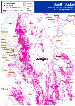
Seasonal Flood Analysis for Ayod County in Jonglei State as of 29 September 2020.
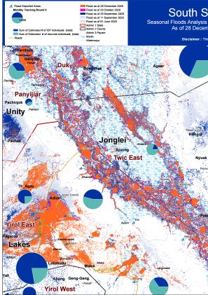
Seasonal Flood Analysis for Twic East County in Jonglei State as of 28 December 2020.
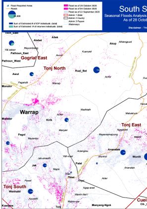
Seasonal Flood Analysis for Tonj East County in Warrap State as of 29 October 2020.
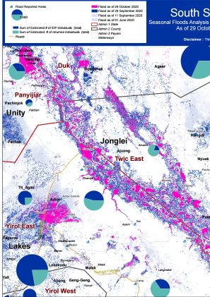
Seasonal Flood Analysis for Twic East County in Jonglei State as of 29 October 2020.
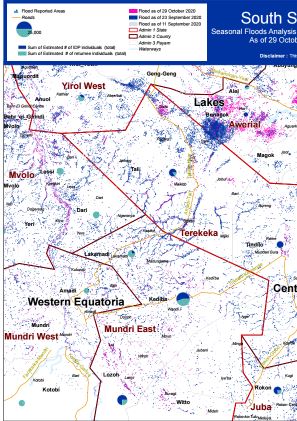
Seasonal Flood Analysis for Terekeka County in Central Equatoria State as of 29 October 2020.
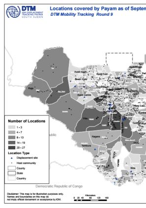
This document contains country-level overview of location types assessed during Mobility Tracking Round 9 conducted between July and September 2020.
This document contains payam/sub-area level overview of assessed locations with confirmed presence of IDPs and returnees (Mobility Tracking Round 9, September 2020).
This document contains state-level maps with indicated location types (IDP, returnee) as per Mobility Tracking Round 9 assessment (September 2020).
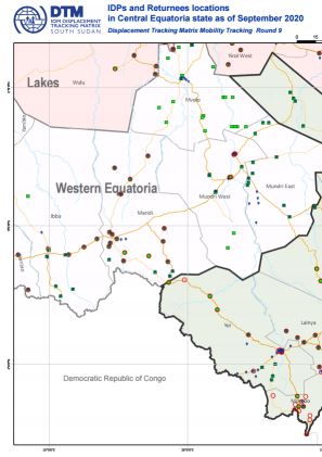
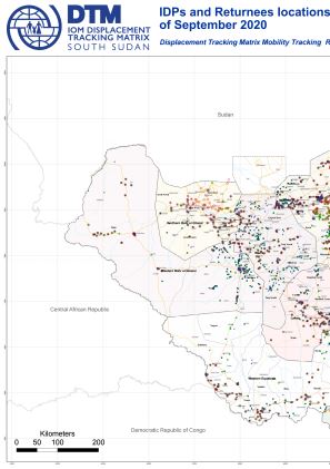
This map displays assessed locations with confirmed presence of IDPs and Returnees (Mobility Tracking Round 9, September 2020).
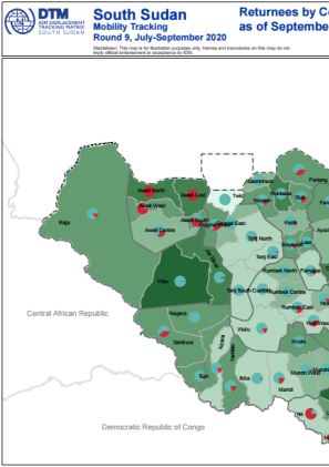
This map displays the number of returnees by county as of September 2020, Round 9 of Mobility Tracking.
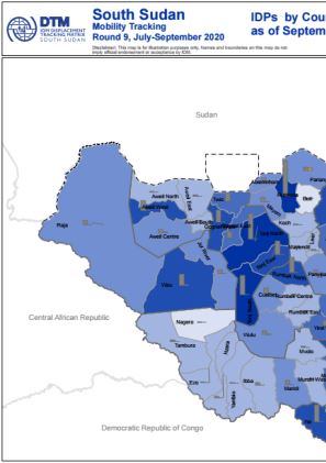
This map displays the number of IDPs by county as of September 2020, Round 9 of Mobility Tracking.
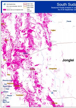
Seasonal Flood Analysis for Duk County in Jonglei State as of 29 September 2020.
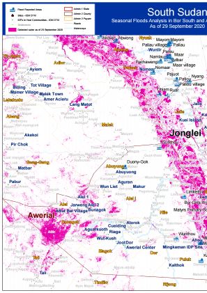
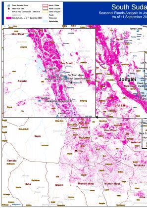
Seasonal Flood Analysis for Bor South County in Jonglei State and Awerial County in Lakes State as of 29 September 2020.
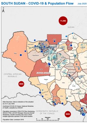
IOM DTM, UNHCR and REACH combined their flow monitoring data for South Sudan with geographically disaggregated data about COVID-19 cases in South Sudan and neighbouring countries compiled by UNICEF. This indicative map of population inflows aims to inform public health measures to reduce the risk of COVID-19 transmission and enable safe mobility. The map shows the total number of incoming individual movements recorded across all flow monitoring points.Data reflects the situation as of 31 July.
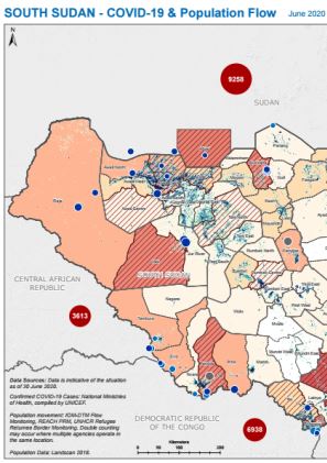
IOM DTM, UNHCR and REACH combined their flow monitoring data for South Sudan with geographically disaggregated data about COVID-19 cases in South Sudan and neighbouring countries compiled by UNICEF. This indicative map of population inflows aims to inform public health measures to reduce the risk of COVID-19 transmission and enable safe mobility. The map shows the total number of incoming individual movements recorded across all flow monitoring points.Data reflects the situation as of 30 June.
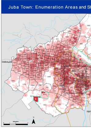
IOM DTM has ben collaborating with South Sudan's National Bureau of Statistics to develop updated enumeration areas for Juba Town and map shelter density using remote sensing data. The aim of this work is to inform the COVID-19 response and enable the roll-out of representative household surveys in collaboration with humanitarian and development partners.
Seasonal Floods Analysis for Twic East and Duk, Jonglei State, with imagery as of 11 September 2020.


DTM API
Making global IDPs data accessible and reliable
The Displacement Tracking Matrix application programming interface (API) accelerates secure sharing of IDPs’ data, simplifying access to data across users and partners to support action, insight and foresight.