Uganda
Suivi des PDI
Mouvements de déplacement
cycle de collecte de données


À propos Uganda
In view of the political and conflict situation in neighboring countries of South Sudan and the Democratic Republic of Congo (DRC), there has been an increasing number of people moving into Uganda. In response to the need for timely and accurate information on the movements and needs of the displaced population, the International Organization for Migration (IOM) in Uganda began implementing the Displacement Tracking Matrix (DTM) in March 2018. The DTM activities conducted in Uganda include Flow Monitoring Registry (FMR) and Flow Monitoring Surveys (FMS), which aim at providing disaggregated data on the movements volume and trends as well as qualitative information on individuals’ educational and vocational backgrounds of travelers, their intended destinations, the routes taken, and the challenges faced along the way. IOM Uganda is currently monitoring population flows at twenty-one points of entry (POE), fifteen on the Ugandan border with DRC and six along the border with South Sudan. The data collected is shared with relevant governmental stakeholders and other humanitarian partners to develop adequate interventions and provide the necessary assistance.
Contacter
DTM Uganda
dtmuganda@iom.int
Bailleurs de fonds
- European Union
The baseline assessment was conducted in 2 Districts (Kisoro & Isingiro) and 1 City (Mbarara City) in Southwestern sub-region of Uganda at the sub county level (19 sub-counties/Admin 2).

Random rains experienced in the Western Region of Uganda triggered hazardous events in the districts of Kasese, Ntoroko, Bundibugyo and in Kampala Capital City in the Central region.

Scattered rains experienced during the months of June and July triggered flash floods and heavy storms. Lightning was reported in the Karamoja region in Amudat district, land conflicts in Wakiso and Amuru while public riots in Kamwenge.

IOM Uganda is pleased to share with you it’s the third Refugee Flow Monitoring report (FMR) for the period between 20 April to 20 May 2024 which is under the EU funded project aiming at “Strengthening Uganda’s national and sub-national institutions and systems to address the challenges of forced

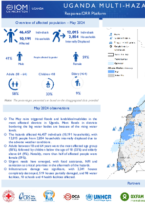
The May rains triggered floods and landslides/mudslides in the most affected districts in Uganda. Most floods in districts bordering the big water bodies are because of the rising water levels.
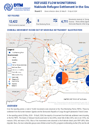
Over the reporting period, a total of 12,422 movements were observed at five Flow Monitoring Points (FMPs).
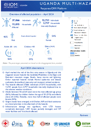
April marked the mid of the first rainy season in Uganda and this triggered natural hazards like landslides/Mudslides in the Elgon and Rwenzori mountain ranges, floods, heavy storms and lightning.
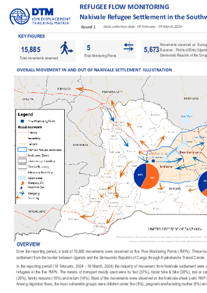
Over the reporting period, a total of 15,885 movements were observed at five Flow Monitoring Points (FMPs) through random interviews with travelers.
In March there were reports of affected people due to Heavy Storms or Hailstorms in the districts of Kanungu (8,620), Namisindwa (825), Bunyangabu (580), Buikwe (262), Mubende (40) and Wakiso (25).

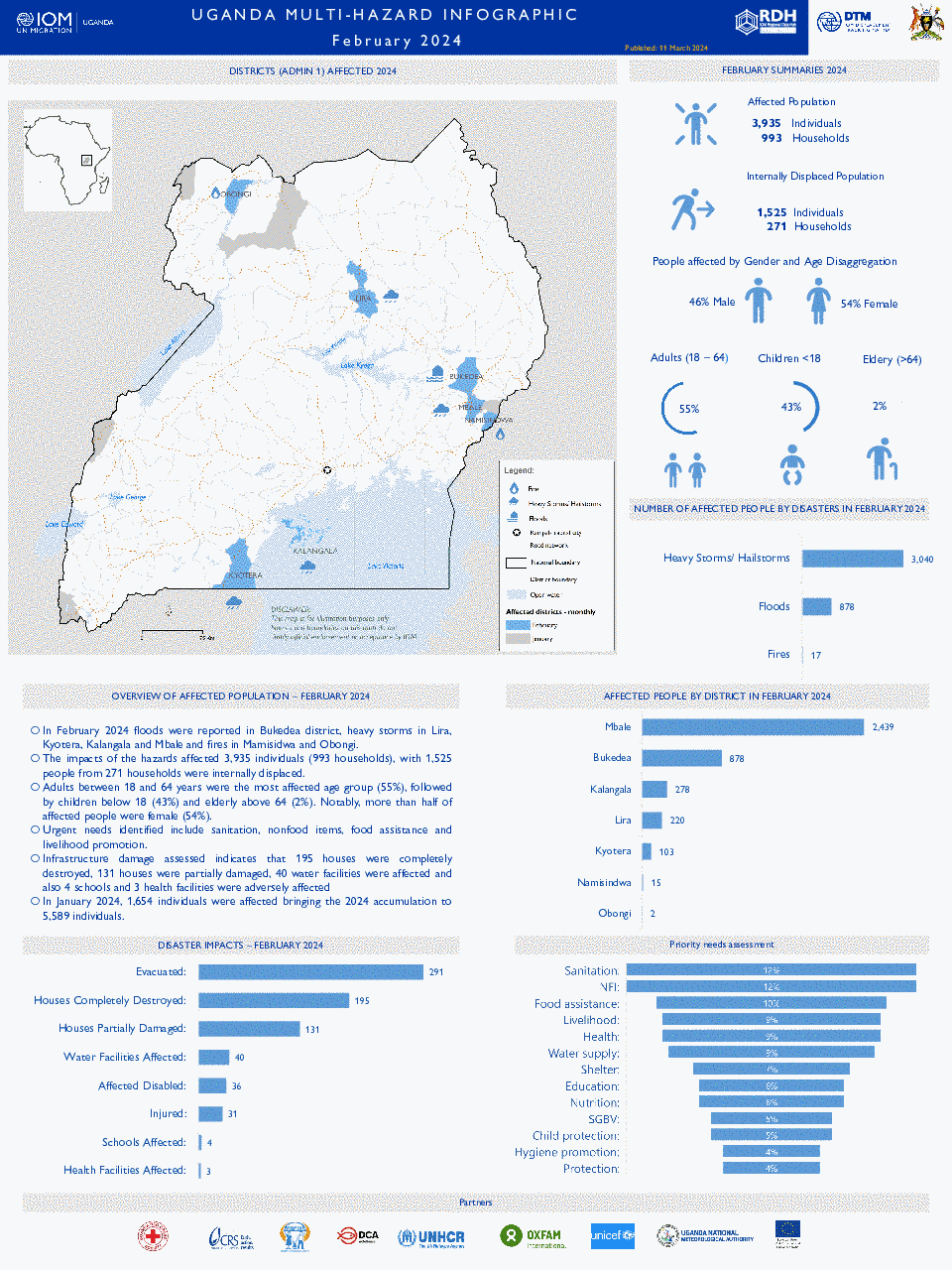
In February 2024, floods were reported in the Bukedea district, heavy storms in Lira, Kyotera, Kalangala and Mbale and fires in Mamisidwa and Obongi. The impacts of the hazards affected 3,935 individuals (993 households) with 1,525 people from 271 households were internally displ
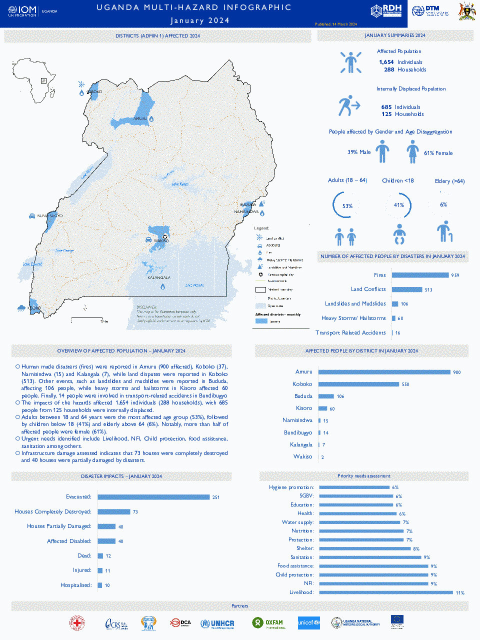
Human made disasters (fires), land disputes and extreme weather events such as landslides, mudslides as well as heavy storms and hailstorms have led to significant devastation in the districts of Amuru, Koboko, Bududa, Kisoro, Namisindwa, Bundibugyo, Kalangala and Wakiso.
As the September to December (SOND) rainfall season winds down, extreme weather events, specifically floods, landslides, hailstorms, and heavy winds have led to significant devastation in the affected districts.

In September 2023, the Prime Minister Office’s, in conjunction with Ministry of Water & Environment and Uganda National Meteorological Authority published an alert on the potential impacts of floods related to el niño during the September – December rainy season.

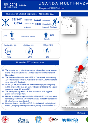
The ongoing heavy rains in the nation triggered extreme weather events which include floods and heavy storms in the month of November.
The month of September marked the beginning of the SOND rainfall season and also the beginning of the El-Nino impact as forecasted by UNMA. These climatic events triggered heavy storms/Hailstorms in the different parts of the nation, floods and landslides/Mudslides.

Disasters have so far affected 95,170 individuals and displaced over 7,662 people as reported from January to August 2023.

In the month of July 2023, floods were reported in Kapelebyong & Gulu, human epidemics outbreaks (Cholera) in Kayunga, Namayingo & Nakaseke (rift valley fever) and road accidents in Kagadi and Kampala.

There was a notable reduction on the impacts, extent and intensity of disaster in the month of June. Floods were reported in Kasese, Bukedea and Kapelabyong. Heavy storms occurred in Namisindwa and Manafwa while landslides in Bududa.

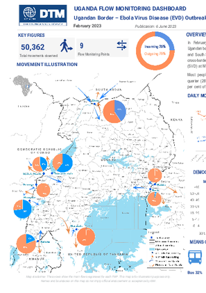
In February 2023, 50,362 movements were tracked at nine Flow Monitoring Points (FMPs) at the Ugandan border with Kenya, the Democratic Republic of Congo, the United Republic of Tanzania, Rwanda and South Sudan.
In January 2023, 58,629 movements were tracked at nine Flow Monitoring Points (FMPs) at the Ugandan border with Kenya, the Democratic Republic of Congo, the United Republic of Tanzania, Rwanda and South Sudan.

Floods, accidents, drought, landslides and heavy winds accompanied by hailstorms were the major hazard events reported in the month of April. The disasters affected a total of 19,311 individuals, representing 3,857 households while 552 individuals from 394 households were interna
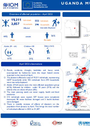
Floods, accidents, drought, landslides and heavy winds accompanied by hailstorms were the major hazard events reported in the month of April. The disasters affected a total of 19,311 individuals, representing 3,857 households while 552 individuals from 394 households were internally displaced.

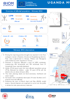
During the reporting period, drought was reported in the Teso subregion mainly in Katakwi, Amuria and Kapelabyong districts. Fires were experienced in Amuria, Wakiso and Ntungamo while hailstorms were reported in Tororo. Disasters in February affected a total of 2,890 i

During the reporting period, drought was reported in the Teso subregion mainly in Katakwi, Amuria and Kapelabyong districts. Fires were experienced in Amuria, Wakiso and Ntungamo while hailstorms were reported in Tororo.
Uganda – Multi-Hazard Response/DRR Platform (Sep - Oct 2024)
2024-10-31
<p>- As of November 10, 2024, the Ministry of Health reported 443 Mpox cases across 37 districts. Males accounted for 56% of cases, with females making up the remaining 44%. Additionally, September and October saw widespread extreme weather events, including floods, landslides, heavy storms,…
Uganda - Multi-Hazard Response/DRR Platform (June & July 2024)
2024-07-21
<p>Scattered rains experienced during the months of June and July triggered flash floods and heavy storms. Lightning was reported in the Karamoja region in Amudat district, land conflicts in Wakiso and Amuru while public riots in Kamwenge. The hazards affected <strong>12,446</strong…
Uganda - Multi-Hazard Response/DRR Platform (May 2024)
2024-05-28
<p>The May rains triggered floods and landslides/mudslides in the most affected districts in Uganda. Most floods in districts bordering the big water bodies are because of the rising water levels. The hazards affected <strong>46,457</strong> individuals (<strong>10,191</…
Uganda - Multi-Hazard Response/DRR Platform (April 2024)
2024-05-03
<p>In April 2024, the hazards affected <strong>37,866</strong> individuals (<strong>11,015</strong> households), with <strong>12,731</strong> people from <strong>3,717</strong> households internally displaced due to the adverse weather…
Uganda - Multi-Hazard Response/DRR Platform (March 2024)
2024-03-29
<p>In March, the impacts of the hazards affected <strong>10,390</strong> individuals (<strong>2,387</strong> households), with 426 people from 91 households were internally displaced. Children below the age of 18 were the most affected age group (67%), followed by…
Uganda - Multi-Hazard Response/DRR Platform (February 2024)
2024-02-29
<p>In February 2024, the impacts of the hazards affected <strong>3,935 </strong>individuals (<strong>993</strong> households), with <strong>1,525</strong> people from<strong> 271</strong> households were internally displaced.</p>
Uganda - Multi-Hazard Response/DRR Platform (January 2024)
2024-02-01
<p>In January, the impacts of the hazards affected <strong>1,654 </strong>individuals (<strong>288</strong> households), with <strong>685 </strong>people from <strong>125</strong> households were internally displaced.</p>
Uganda - Multi-Hazard Response/DRR Platform (December 2023)
2023-12-29
<p>As the September to December (SOND) rainfall season winds down, extreme weather events, specifically floods, landslides, hailstorms, and heavy winds have led to significant devastation in the affected districts. The disasters have adversely impacted <strong>7,052 individuals</…
Uganda - Multi-Hazard Response/DRR Platform (November 2023)
2023-11-30
<p>The ongoing heavy rains in the nation triggered extreme weather events which include floods and heavy storms in the month of November.</p><ul><li>The disasters affected a total of <strong>38,547 individuals</strong>, representing 7,854 households while 15,962…
Uganda - Emergency Event Tracking (EET) - EL Niño Impact Tracking (November 2023)
2023-11-14
<p>In September 2023, the Prime Minister Office’s, in conjunction with Ministry of Water &amp; Environment and Uganda National Meteorological Authority published an alert on the potential impacts of floods related to el niño during the September – December rainy season. To monitor those,…
Uganda - Multi-Hazard Response/DRR Platform (September 2023)
2023-09-30
In September, 2557 individuals and 662 households were affected. 246 individuals and 57 households were internally displaced.
Uganda - Multi-Hazard Response/DRR Platform (August 2023)
2023-08-31
In August 2023, 2904 individuals and 864 households were affected. 1041 individuals and 24 households were internally displaced.
Uganda - Multi-Hazard Response/DRR Platform (Jan-July 2023)
2023-07-31
From January to July 2023, 90,226 people were affected, and 2,401 people were displaced by multi-hazards in Uganda.
Uganda - Multi-Hazard Response/DRR Platform (July 2023)
2023-07-30
In the month of July 2023, floods were reported in Kapelebyong & Gulu, human epidemics outbreaks (Cholera) in Kayunga, Namayingo & Nakaseke (rift valley fever) and road accidents in Kagadi and Kampala. The disasters affected a total of 2,040 individuals, representing 300 households and…
Uganda - Multi-Hazard Response/DRR Platform (2022)
2022-12-31
This dataset shows the number of individuals and households affected and the impacts of disasters on a monthly basis at a district (Admin 2) level in Uganda. A total of 171,148 individuals were affected in 2022.
Uganda — Baseline Assessment — May 2020 — Round 1
2020-05-29
A baseline assessment is a sub-component of mobility tracking. It aims to collect data on IDP, migrant or returnee population presence in a defined administrative area of the country.
Uganda- Flow monitoring (22 Dec 2018 - 05 Jan 2019)
2019-01-05
Flow monitoring aims to derive quantitative estimates of the flow of individuals through specific locations and to collect information about the profile, intentions and needs of the people moving and to quantify highly mobile populations by providing a picture of complex mobility dynamics.
Uganda- Flow monitoring (07 - 21 December 2018)
2018-12-21
Flow monitoring aims to derive quantitative estimates of the flow of individuals through specific locations and to collect information about the profile, intentions and needs of the people moving and to quantify highly mobile populations by providing a picture of complex mobility dynamics.
Uganda- Flow monitoring (16 - 30 November 2018)
2018-11-30
Flow monitoring aims to derive quantitative estimates of the flow of individuals through specific locations and to collect information about the profile, intentions and needs of the people moving and to quantify highly mobile populations by providing a picture of complex mobility dynamics.
Multiple maps illustrating all outgoing and incoming movements from Uganda tracked by the Displacement Tracking Matrix’s Flow Monitoring project. The maps are comprised of data from different periods, with the earliest from April 2018.


DTM Global Survey 2023
The Displacement Tracking Matrix (DTM) Global Survey 2023 is an annual stocktaking exercise which aims to present IOM DTM's operations and activities transparently. The Global Survey focuses on operations active from January 1 to December 31, 2023, with data collection occurring from February to April 2024.