South Sudan
South Sudan
Suivi des PDI
Mouvements de déplacement
cycle de collecte de données


À propos South Sudan
Conflict and instability in South Sudan have resulted in large-scale internal and cross-border displacement since the December 2013 crisis of over 4 million individuals. In September 2018, the Revitalized Agreement for the Resolution of the Conflict in South Sudan (R-ARCSS) was signed between the major warring parties. Whilst overall there have been improvements in security since and returns are ongoing, fighting and communal clashes (frequently linked to cattle raiding) continue to trigger new displacements and the situation remains volatile.
DTM South Sudan’s toolbox is designed to meet critical information gaps during all phases of response, from preparedness, to intervention and transition/recovery. DTM South Sudan provides country-wide figures on the numbers, locations and priority needs of IDPs and returnees updated on a quarterly and ad-hoc basis. The programme undertakes biometric registration in selected parts of the country to support partners with reaching intended beneficiaries during distributions. Flow monitoring data is collected on a daily basis at displacement sites, key transit hubs and border crossing points to identify mobility dynamics of migrants including IPDs and returnees. Through ad hoc surveys, headcounts, infrastructure/service mapping exercises and other assessments, DTM provides additional information to support partners in planning their response.
Contacter
IOM South Sudan DTM Juba
ISSDTM@iom.int
Current Donors
- Switzerland
- Japan
- DFID
- ECHO
- OCHA
- OFDA
- Canada (DFATD)
- WFP
- UN Peacebuilding Fund
- World Bank
Mobility tracking aims to quantify the presence and needs of internally displaced persons (IDPs), returnees and relocated individuals in displacement sites and host communities across South Sudan.

Mobility tracking aims to quantify the presence and needs of internally displaced persons (IDPs), returnees and relocated individuals in displacement sites and host communities across South Sudan.

Mobility tracking aims to quantify the presence and needs of internally displaced persons (IDPs), returnees and relocated individuals in displacement sites and host communities across South Sudan.
Mobility tracking aims to quantify the presence and needs of internally displaced persons (IDPs), returnees and relocated individuals in displacement sites and host communities across South Sudan.
Mobility tracking aims to quantify the presence and needs of internally displaced persons (IDPs), returnees and relocated individuals in displacement sites and host communities across South Sudan. The assessments are repeated at regular intervals to track mobility dynamics and needs over time.
DTM conducts ad hoc Event Tracking assessments in order to map instances of new displacement or return in short dedicated reports.
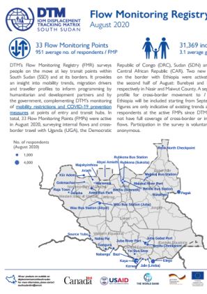
DTM’s Flow Monitoring Registry (FMR) surveys people on the move at key transit points within South Sudan (SSD) and at its borders.
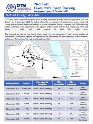
DTM focal points conducted emergency Event Tracking assessments in Adior and Malek payams of Yirol East County on 6 September 2020, to collect information on locations of displacement, urgent needs and demographic profiles of households displaced as a result of flooding.
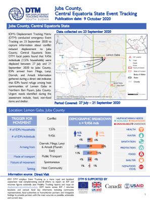
IOM’s Displacement Tracking Matrix (DTM) conducted emergency Event Tracking on 23 September 2020 to capture information about conflict induced displacement to Juba County, Central Equatoria State.
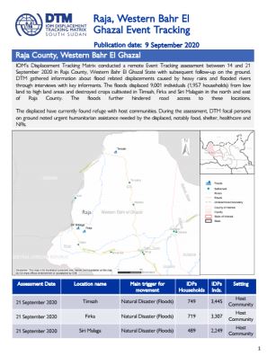
IOM’s Displacement Tracking Matrix conducted a remote Event Tracking assessment between 14 and 21 September 2020 in Raja County, Western Bahr El Ghazal State with subsequent follow-up on the ground.
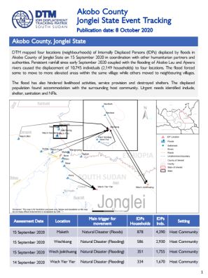
DTM mapped four locations (neighbourhoods) of Internally Displaced Persons (IDPs) displaced by floods in Akobo County of Jonglei State on 15 September 2020 in coordination with other humanitarian partners and authorities.
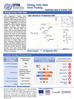
IOM’s Displacement Tracking Matrix conducted Emergency Event Tracking on 16 September 2020 through interviews with key informants in order to gather information on locations of displacement, key needs and demographic profiles of displaced households affected by natural disaster (flooding).
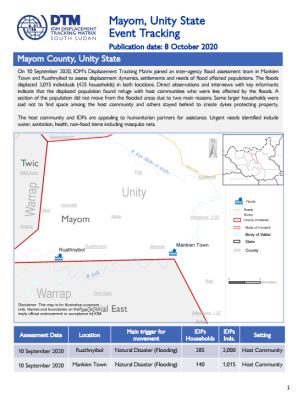
On 10 September 2020, IOM’s Displacement Tracking Matrix joined an inter-agency flood assessment team in Mankien Town and Ruathnyibol to assess displacement dynamics, settlements and needs of flood affected populations. The floods displaced 3,015 individuals (425 households) in both locations.
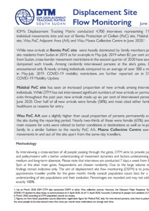
IOM’s Displacement Tracking Matrix conducted 4,700 interviews representing 11,661 individual movements into and out of Bentiu Protection of Civilian (PoC) site, Malakal PoC site, Wau PoC Adjacent Area (AA) and Wau Masna Collective Centre in June 2020.
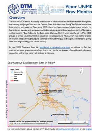
The first half of 2020 was marked by an escalation in sub-national and localized violence throughout the country and Jonglei State and the Greater Pibor Administrative Area (GPAA) have been major hotspots for such violence.
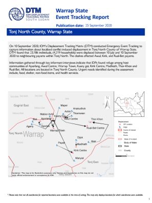
On 10 September 2020, IOM’s Displacement Tracking Matrix (DTM) conducted Emergency Event Tracking to capture information about localized conflict induced displacement in Tonj North County of Warrap State.
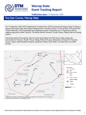
On 16 September 2020, IOM’s Displacement Tracking Matrix (DTM) conducted Emergency Event Tracking to capture information about flood induced displacement in Tonj East County of Warrap State.
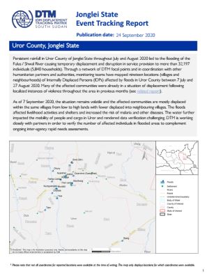
Persistent rainfall in Uror County of Jonglei State throughout July and August 2020 led to the flooding of the Fulus / Shwal River causing temporary displacement and disruption in service provision to more than 32,197 individuals (5,840 households).
On 20 and 21 August 2020, clashes between NAS and SSPSF forces in Juba and Lainya Counties led to the displacement of people living in the surrounding areas.

Severe flooding caused by heavy rainfall in Unity State caused temporary displacement and disruption in service provision to more than 4,702 individuals (608 households).

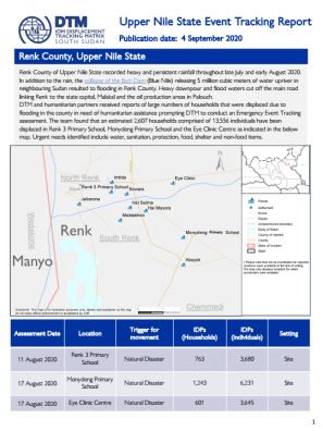
Renk County of Upper Nile State recorded heavy and persistent rainfall throughout late July and early August 2020.In addition to the rain, the co
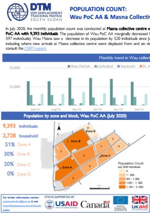
In July 2020, the monthly population count was conducted at Masna collective centre where 5,496 individuals were identified and Wau PoC AA with 9,393 individuals. The population of Wau PoC AA marginally decreased from 9,990 individuals in June 2020 (decreased by 597 individuals).
As of 7 August 2020, the cumulative total of confirmed COVID-19 cases in South Sudan stands at 2,472 with 47 deaths and 1,252 recoveries according to the Republic of South Sudan’s Ministry of Health.
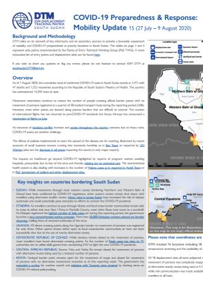
As of 7 August 2020, the cumulative total of confirmed COVID-19 cases in South Sudan stands at 2,472 with 47 deaths and 1,252 recoveries according to the Republic of South Sudan’s Ministry of Health.

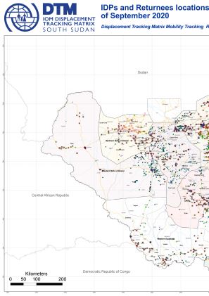
This map displays assessed locations with confirmed presence of IDPs and Returnees (Mobility Tracking Round 9, September 2020).
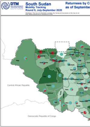
This map displays the number of returnees by county as of September 2020, Round 9 of Mobility Tracking.
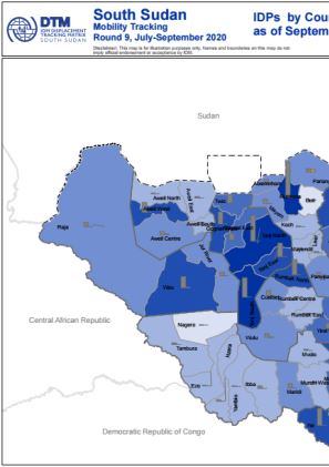
This map displays the number of IDPs by county as of September 2020, Round 9 of Mobility Tracking.
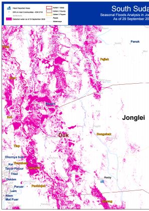
Seasonal Flood Analysis for Duk County in Jonglei State as of 29 September 2020.
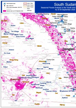
Seasonal Flood Analysis for Bor South County in Jonglei State and Awerial County in Lakes State as of 29 September 2020.
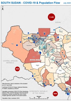
IOM DTM, UNHCR and REACH combined their flow monitoring data for South Sudan with geographically disaggregated data about COVID-19 cases in South Sudan and neighbouring countries compiled by UNICEF. This indicative map of population inflows aims to inform public health measures to reduce the risk of COVID-19 transmission and enable safe mobility. The map shows the total number of incoming individual movements recorded across all flow monitoring points.Data reflects the situation as of 31 July.
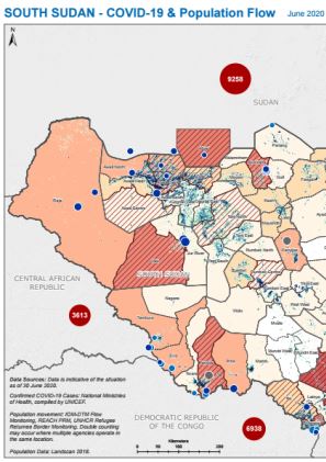
IOM DTM, UNHCR and REACH combined their flow monitoring data for South Sudan with geographically disaggregated data about COVID-19 cases in South Sudan and neighbouring countries compiled by UNICEF. This indicative map of population inflows aims to inform public health measures to reduce the risk of COVID-19 transmission and enable safe mobility. The map shows the total number of incoming individual movements recorded across all flow monitoring points.Data reflects the situation as of 30 June.
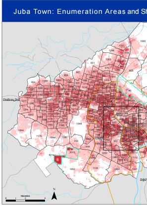
IOM DTM has ben collaborating with South Sudan's National Bureau of Statistics to develop updated enumeration areas for Juba Town and map shelter density using remote sensing data. The aim of this work is to inform the COVID-19 response and enable the roll-out of representative household surveys in collaboration with humanitarian and development partners.
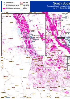
Seasonal Floods Analysis for Twic East and Duk, Jonglei State, with imagery as of 11 September 2020.
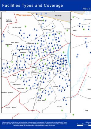
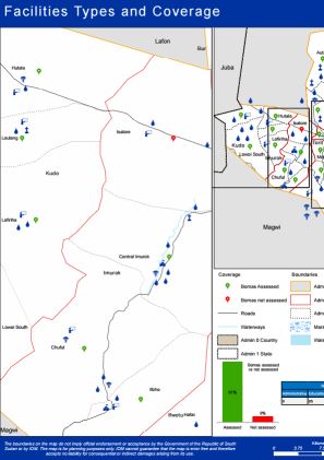
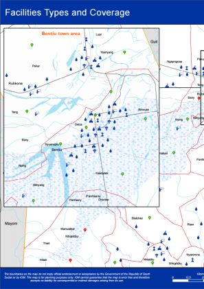
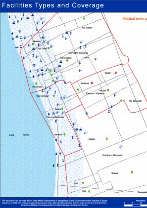
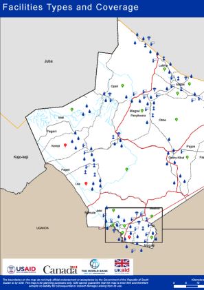
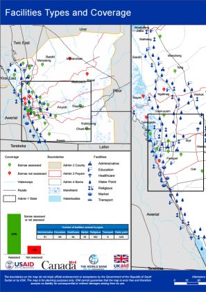
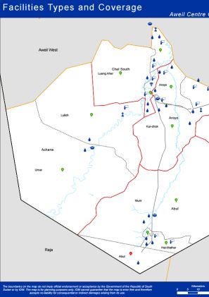
Since the beginning of the exercise in the last quarter of 2019, IOM’s Displacement Tracking Matrix (DTM) conducted Village Assessment Survey (VAS) across 7 counties covering 182 out of 219 bomas (achieving 83 per cent coverage) in Wau, Rubkona, Bor South, Torit, Magwi, Aweil Centre and Malakal counties. Additional 9 focus group discussions were conducted, due to varying perspectives on boma boundaries. To supplement the findings from the boma questionnaire, key informant interviews were conducted at 560 educational facilities and 150 health facilities. In addition to this, Facility, Infrastructure and Service mapping component geo referenced 3,227 facilities including administrative buildings, education facilities, healthcare facilities, markets, religious buildings, transport points and water points.
Since the beginning of the exercise in the last quarter of 2019, IOM’s Displacement Tracking Matrix (DTM) conducted Village Assessment Survey (VAS) across 7 counties covering 182 out of 219 bomas (achieving 83 per cent coverage) in Wau, Rubkona, Bor South, Torit, Magwi, Aweil Centre and Malakal counties. Additional 9 focus group discussions were conducted, due to varying perspectives on boma boundaries. To supplement the findings from the boma questionnaire, key informant interviews were conducted at 560 educational facilities and 150 health facilities. In addition to this, Facility, Infrastructure and Service mapping component geo referenced 3,227 facilities including administrative buildings, education facilities, healthcare facilities, markets, religious buildings, transport points and water points.
Since the beginning of the exercise in the last quarter of 2019, IOM’s Displacement Tracking Matrix (DTM) conducted Village Assessment Survey (VAS) across 7 counties covering 182 out of 219 bomas (achieving 83 per cent coverage) in Wau, Rubkona, Bor South, Torit, Magwi, Aweil Centre and Malakal counties. Additional 9 focus group discussions were conducted, due to varying perspectives on boma boundaries. To supplement the findings from the boma questionnaire, key informant interviews were conducted at 560 educational facilities and 150 health facilities. In addition to this, Facility, Infrastructure and Service mapping component geo referenced 3,227 facilities including administrative buildings, education facilities, healthcare facilities, markets, religious buildings, transport points and water points.
Since the beginning of the exercise in the last quarter of 2019, IOM’s Displacement Tracking Matrix (DTM) conducted Village Assessment Survey (VAS) across 7 counties covering 182 out of 219 bomas (achieving 83 per cent coverage) in Wau, Rubkona, Bor South, Torit, Magwi, Aweil Centre and Malakal counties. Additional 9 focus group discussions were conducted, due to varying perspectives on boma boundaries. To supplement the findings from the boma questionnaire, key informant interviews were conducted at 560 educational facilities and 150 health facilities. In addition to this, Facility, Infrastructure and Service mapping component geo referenced 3,227 facilities including administrative buildings, education facilities, healthcare facilities, markets, religious buildings, transport points and water points.
Since the beginning of the exercise in the last quarter of 2019, IOM’s Displacement Tracking Matrix (DTM) conducted Village Assessment Survey (VAS) across 7 counties covering 182 out of 219 bomas (achieving 83 per cent coverage) in Wau, Rubkona, Bor South, Torit, Magwi, Aweil Centre and Malakal counties. Additional 9 focus group discussions were conducted, due to varying perspectives on boma boundaries. To supplement the findings from the boma questionnaire, key informant interviews were conducted at 560 educational facilities and 150 health facilities. In addition to this, Facility, Infrastructure and Service mapping component geo referenced 3,227 facilities including administrative buildings, education facilities, healthcare facilities, markets, religious buildings, transport points and water points.
Since the beginning of the exercise in the last quarter of 2019, IOM’s Displacement Tracking Matrix (DTM) conducted Village Assessment Survey (VAS) across 7 counties covering 182 out of 219 bomas (achieving 83 per cent coverage) in Wau, Rubkona, Bor South, Torit, Magwi, Aweil Centre and Malakal counties. Additional 9 focus group discussions were conducted, due to varying perspectives on boma boundaries. To supplement the findings from the boma questionnaire, key informant interviews were conducted at 560 educational facilities and 150 health facilities. In addition to this, Facility, Infrastructure and Service mapping component geo referenced 3,227 facilities including administrative buildings, education facilities, healthcare facilities, markets, religious buildings, transport points and water points.
Since the beginning of the exercise in the last quarter of 2019, IOM’s Displacement Tracking Matrix (DTM) conducted Village Assessment Survey (VAS) across 7 counties covering 182 out of 219 bomas (achieving 83 per cent coverage) in Wau, Rubkona, Bor South, Torit, Magwi, Aweil Centre and Malakal counties. Additional 9 focus group discussions were conducted, due to varying perspectives on boma boundaries. To supplement the findings from the boma questionnaire, key informant interviews were conducted at 560 educational facilities and 150 health facilities. In addition to this, Facility, Infrastructure and Service mapping component geo referenced 3,227 facilities including administrative buildings, education facilities, healthcare facilities, markets, religious buildings, transport points and water points.
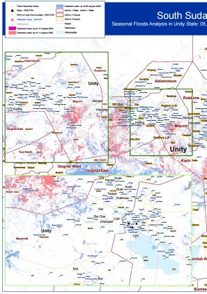
Seasonal Floods Analysis in Unity State for 5, 11 and 12 August 2020
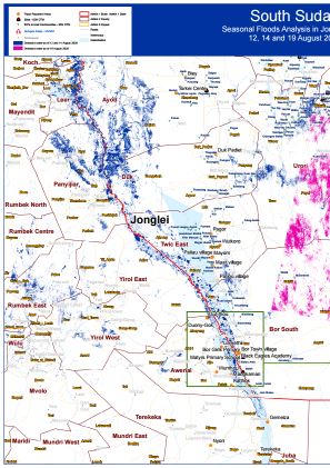
Seasonal Floods Analysis in Jonglei State for12, 14 and 19 August 2020
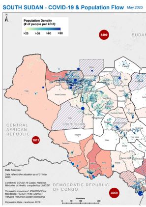
IOM DTM, UNHCR and REACH combined their flow monitoring data for South Sudan with geographically disaggregated data about COVID-19 cases in South Sudan and neighbouring countries compiled by UNICEF, with the aim of mapping population inflows at risk of COVID-19 transmission. This map shows the total number of incoming individual movements recorded across all flow monitoring points.Data reflects the situation as of 31 May.
IOM DTM, UNHCR and REACH combined their flow monitoring data for South Sudan with geographically disaggreagated data about COVID-19 cases in South Sudan and neighbouring countries compiled by UNICEF, with the aim of mapping population flows that may be vulnerable to COVID-19 transmission. Data on individuals travelling from areas with COVID-19 cases includes both those entering from neighbouring countries as well as internal movements within South Sudan.The data reflects the situation as of 31 May

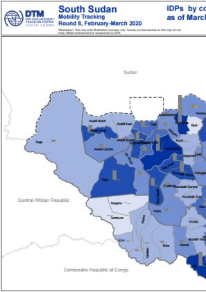
This map displays the number of IDPs by county as of March 2020 (round 8 of mobility tracking).
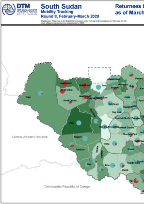
This map displays the number of returnees by county as of March 2020 (round 8 of mobility tracking).
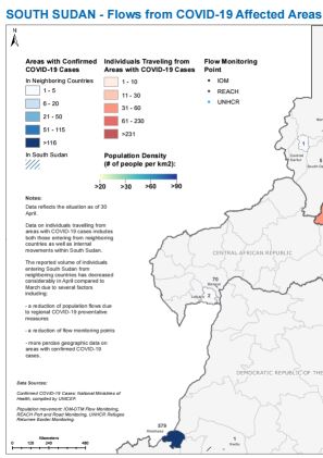
IOM DTM, UNHCR and REACH combined their flow monitoring data for South Sudan with geographically disaggregated data about COVID-19 cases in neighbouring countries compiled by UNICEF, with the aim of mapping population inflows at risk of COVID-19 transmission. Data on individuals travelling from areas with COVID-19 cases includes both those entering from neighbouring countries as well as internal movements within South Sudan. The reported volume of individuals entering South Sudan from neighbouring countries has decreased considerably in April compared to March due to several factors:a reduction of population flows due to regional COVID-19 preventive measuresa reduction of flow monitoring pointsmore precise geographic data on areas with confirmed COVID-19 casesData reflects the situation as of 30 April.
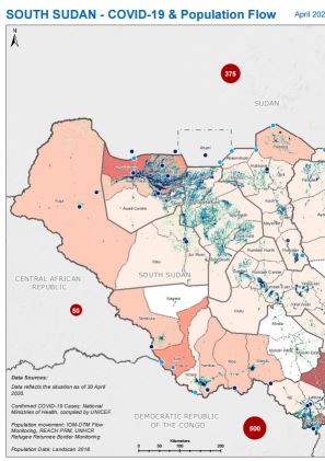
IOM DTM, UNHCR and REACH combined their flow monitoring data for South Sudan with geographically disaggreagated data about COVID-19 cases in neighbouring countries compiled by UNICEF, with the aim of mapping population inflows at risk of COVID-19 transmission. Data on individuals travelling from areas with COVID-19 cases includes both those entering from neighbouring countries as well as internal movements within South Sudan. The reported volume of individuals entering South Sudan from neighboring countries has decreased considerably in April compared to March due to several factors:a reduction of population flows due to regional COVID-19 preventative measuresa reduction of flow monitoring pointsmore precise geographic data on areas with confirmed COVID-19 casesData reflects the situation as of 30 April.

DTM Global Survey 2023
The Displacement Tracking Matrix (DTM) Global Survey 2023 is an annual stocktaking exercise which aims to present IOM DTM's operations and activities transparently. The Global Survey focuses on operations active from January 1 to December 31, 2023, with data collection occurring from February to April 2024.