South Sudan — Seasonal Flooding Maps (November 2019)
Nov 02 2019
- Mobility Tracking
- Event Tracking
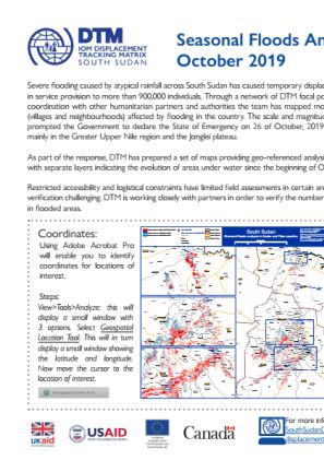
Severe flooding caused by atypical rainfall across South Sudan has caused temporary displacement and disruption in service provision to more than 900,000 individuals. Through a network of DTM focal points in the field and in coordination with other humanitarian partners and authorities the team has mapped more than 250 locations (villages and neighbourhoods) affected by flooding in the country. The scale and magnitude of the flooding has prompted the Government to declare the State of Emergency on 26 October 2019 in 27 different areas, mainly in the Greater Upper Nile region and the Jonglei plateau.
As part of the response, DTM has prepared a set of maps providing geo-referenced analysis of the flooded areas with separate layers indicating the evolution of areas under water since the beginning of October 2019.

DTM API
Making global IDPs data accessible and reliable
The Displacement Tracking Matrix application programming interface (API) accelerates secure sharing of IDPs’ data, simplifying access to data across users and partners to support action, insight and foresight.