Malawi
Desplazados internos rastreados
Movimientos de desplazamiento
Ronda de recopilación de datos


Sobre Malawi
Since the beginning of January 2015, heavy rains have affected 15 districts of Malawi, in particular in the Southern Region, resulting in the displacement of about 230,000 persons. Malawi announced the Declaration of State of Disaster mid-January and a UNDAC deployed to support the Department of Disaster Management Affairs (DoDMA) in assessing the situation throughout the country. While approximately 250 displacement sites have been identified by DoDMA and the humanitarian community, site locations, demographics and information related to IDP needs remain weak.
In order to gather specific information regarding the status and location of IDPs and conditions in displacement sites in the context of the current humanitarian crisis, the International Organization for Migration (IOM), in close collaboration with the Department of Disaster Management Affairs (DoDMA), began the Displacement Tracking Matrix (DTM) program. The DTM is an information management tool developed by IOM and regularly used in emergencies by the Camp Coordination and Camp Management (CCCM) cluster which aims to strengthen the multi-sectoral data on displacement trends and IDPs' needs that is available to government and humanitarian partners. IOM Malawi's DTM reports are designed to regularly capture, process, and disseminate information to provide a better understanding of the needs, numbers and movements of internally displaced persons (IDPs) in Malawi.
DTM assessments are carried out by IOM in partnership with non-governmental organization (NGO) partners, including Save the Children, Sustainable Rural Community Development (SURCOD) and All Hands Volunteers. Local government officers in the six most affected districts of Blantyre, Chikwawa, Mulanje, Nsanje, Phalombe, and Zomba continue to provide valuable support.
Contacto
Martin Tsere
Senior DTM Field Assistant
mtsere@iom.int
DTM Malawi
DTMMalawi@iom.int
Para obtener resultados de búsqueda más avanzados, vaya a la Página de búsqueda avanzada de informes
Over the reporting period, a total of 1,175 cross-border movements were observed at the Flow Monitoring Points (FMPs). The average daily number of flows was 56.

Over the reporting period, a total of 2,174 cross-border movements were observed at the Flow Monitoring Points (FMPs). The average daily number of flows was 104.

Over the reporting period, a total of 822 cross-border movements were observed at the Flow Monitoring Points (FMPs) between Malawi and the United Republic of Tanzania. The average daily number flows was 46.

Over the reporting period, a total of 2,100 cross-border movements were observed at the Flow Monitoring Points (FMPs) between Malawi and Mozambique. The average daily number of flows was 124.

This report is an overview of the data collected from 1 to 31 July 2024 at Mangochi FMP in Malawi along the border with Mozambique.

This report is an overview of the data collected from 1 to 31 July 2024 at Karonga FMP in Malawi along the border with the United Republic of Tanzania.

This report is an overview of the data collected from 1 to 30 June 2024 at Karonga FMP in Malawi along the border with the United Republic of Tanzania.

This report is an overview of the data collected from 1 to 30 June 2024 at Mangochi FMP in Malawi along the border with Mozambique.

This report is an overview of the data collected from 1 to 31 May 2024 at Mangochi FMP in Malawi along the border with Mozambique and Karonga FMP in Malawi along the border with the United Republic of Tanzania.

This report is an overview of the data collected from 1 to 30 April 2024 at Mangochi FMP in Malawi along the border with Mozambique and Karonga FMP in Malawi along the border with the United Republic of Tanzania.

This report is an overview of the data collected from 1 to 31 March 2024 at Mangochi FMP in Malawi along the border with Mozambique and Karonga FMP in Malawi along the border with the United Republic of Tanzania.

Over the reporting period, a total of 2,754 cross-border movements were observed at the Flow Monitoring Points (FMPs). The average daily number flows was 131.

This report is an overview of the data collected from 1 to 31 January 2024 at Mangochi FMP in Malawi along the border with Mozambique and Karonga FMP in Malawi along the border with the United Republic of Tanzania.

This report provides an overview of Round 1 of IOM's Multi-Sectoral Location Needs Assessments of the different IDP sites in Malawi.

This report details the site profiles as determined by Multi-Sectoral Location Assessments (MSLA). A summary overview can be accessed here.

Following the passage of tropical storm Ana across southern Malawi, the districts of Chikwawa, Mulanje, Nsanje and Phalombe have been severely hit by torrential and persistent rains, although there are reports of other districts also been affected by the onset, such as Mulanje, Chiradzulu and Nen

In response to the Member State requests of the Southern African Development Community (SADC) to enhance the availability of migration-related data to develop policies and programming responses based on evidence and to improve migration governance at the national and regional levels, the Inter

This Dashboard provides an analysis of the trends in population mobility observed at Seventeen (17) active Flow Monitoring Points (FMPs) established at unofficial border crossings.

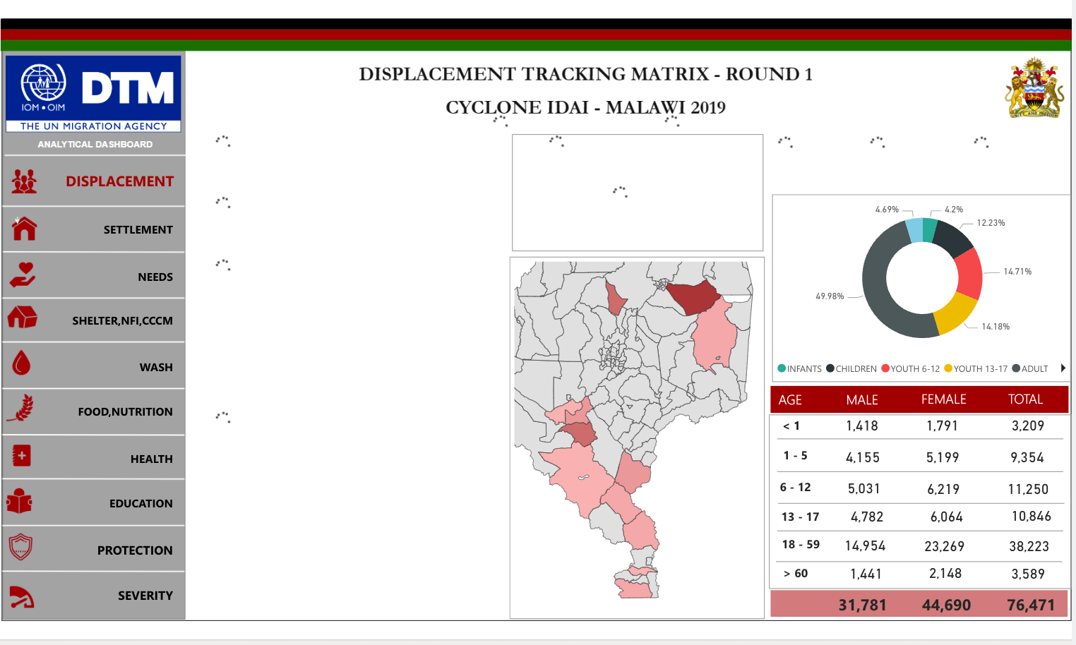
Since the beginning of March 2019, Malawi experienced floods and sustained heavy rains caused by the tropical cyclone Idai weather system.

The Multi-Sectoral Location Assessments conducted from 25 April to 28 April 2019 by DTM teams in 81 sites located in Chikwawa, Nsanje, Phalombe and Zomba districts allowed us to produice these Site Profiles.

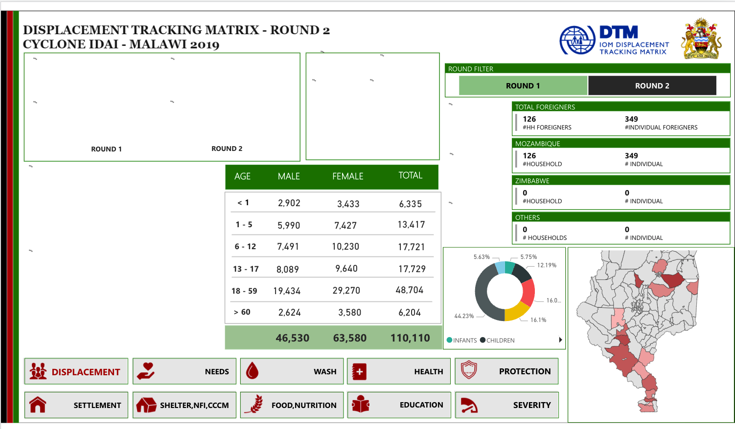
From 1 — 6 April 2019 IOM, in close coordination with the Government of Malawi through the Department of Disaster Management Affairs (DoDMA), conducted DTM Round II multi-sectoral location assessments in 103 displacement sites in Chikwawa, Nsanje, Phalombe, Zomba districts.

The Multi-Sectoral Location Assessments conducted from 1 April to 6 April 2019 by DTM teams in 103 sites located in Chikwawa, Nsanje, Phalombe and Zomba allowed us to produice these Site Profiles.

From the 26th to the 31st of March, IOM in close coordination with the Government of Malawi through the Department of Disaster Management Affairs (DoDMA), conducted multi sectoral location assessments in 64 displacement sites located in Chikwawa, Nsanje, Phalombe,

Since the beginning of March 2019, Malawi has experienced flooding and sustained heavy rain caused by the Tropical Cyclone Idai weather system. According to the Government of Malawi and humanitarian partners, there are 86,980 IDPs in 173 displacement sites in the affected districts.

Para obtener resultados de búsqueda más avanzados, vaya a la Página de búsqueda avanzada de conjuntos de datos
Malawi - Multi-sectoral Location Assessment - Cyclone Freddy - Round 1
2023-04-27
<p>The assessments were carried out following Tropical Cyclone Freddy, which hit the Southern&nbsp;region of Malawi on 12 March 2023 affecting at least 14 districts. The most affected districts are Blantyre, Chikwawa, Nsanje, Mulanje, Phalombe Zomba and Mangochi. Over 426,04&nbsp;…
Malawi — Tropical Storm Ana - Baseline Assessment — Round 1
2022-01-31
A baseline assessment is a sub-component of mobility tracking. It aims to collect data on IDP, migrant or returnee population presence in a defined administrative area of the country. This dataset contains displaced household figures at site level.
Malawi - Multi-sectoral Location Assessments - Cyclone Idai - Round 3
2019-04-28
A site assessment is a sub-component of mobility tracking. It aims to collect data on population presence, living conditions and needs in a particular displacement site or community.
Malawi - Site Assessment - Cyclone Idai Response - Round 2
2019-04-07
A site assessment is a sub-component of mobility tracking. It aims to collect data on population presence, living conditions and needs in a particular displacement site or community.
Malawi - Site Assessment - Cyclone Idai Response - Round 1
2019-03-31
A site assessment is a sub-component of mobility tracking. It aims to collect data on population presence, living conditions and needs in a particular displacement site or community.
Malawi - Site Assessment - Floods 2015 - Round 3
2015-05-31
131 sites remain open, corresponding to approximately 26,100 households and an estimated 107,000 individuals. A decrease of 12,466 IDP households was recorded between the second and third round of the DTM reports; corresponding to a 32% decrease in the number of displaced households. 56% of the IDP…
Malawi - Site Assessment - Floods 2015 - Round 2
2015-04-30
An estimated 147,500 IDPs—approximately 38,600 households—are associated with 192 open sites. 8 sites (4% of the sites) host more than 1000 households. 95 % of open IDP sites have a Camp Management Committee but only 11 % have official Site Management Agency (SMA) or camp monitoring representation…
Malawi - Site Assessment - Floods 2015 - Round 1
2015-03-31
An estimated 162,000 people (approximately 40,500 households) remain displaced in 202 open displacement sites in in the Southern Region districts of Nsanje, Chikwawa, Blantyre, Mulanje, Phalombe, and Zomba as a result of heavy rains and floods that occurred in January 2015. 94 % of open IDP sites…

DTM Global Survey 2023
The Displacement Tracking Matrix (DTM) Global Survey 2023 is an annual stocktaking exercise which aims to present IOM DTM's operations and activities transparently. The Global Survey focuses on operations active from January 1 to December 31, 2023, with data collection occurring from February to April 2024.