Displacement Tracking And Damage Assessment - 14 August 2021 Earthquake (27 August 2021)
- Mobility Tracking
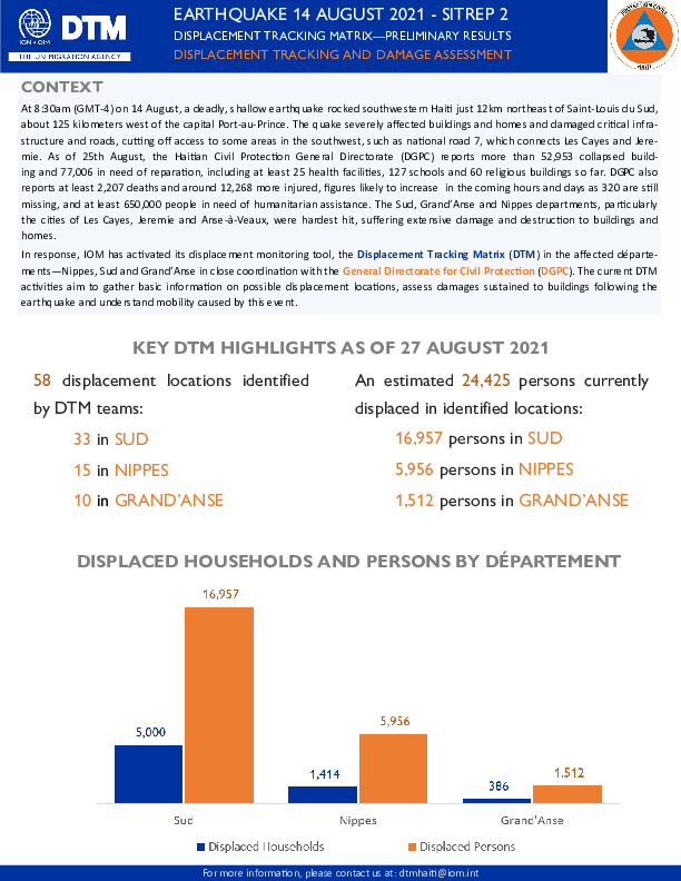
At 8:30am (GMT-4) on 14 August, a deadly, shallow earthquake rocked southwestern Haiti just 12km northeast of Saint-Louis du Sud, about 125 kilometers west of the capital Port-au-Prince. The quake severely affected buildings and homes and damaged critical infrastructure and roads, cutting off access to some areas in the southwest, such as national road 7, which connects Les Cayes and Jeremie. As of 25th August, the Haitian Civil Protection General Directorate (DGPC) reports more than 52,953 collapsed building and 77,006 in need of reparation, including at least 25 health facilities, 127 schools and 60 religious buildings so far. DGPC also reports at least 2,207 deaths and around 12,268 more injured, figures likely to increase in the coming hours and days as 320 are still missing, and at least 650,000 people in need of humanitarian assistance. The Sud, Grand'Anse and Nippes departments, particularly the cities of Les Cayes, Jeremie and Anse-a-Veaux, were hardest hit, suffering extensive damage and destruction to buildings and homes.
In response, IOM has activated its displacement monitoring tool, the Displacement Tracking Matrix (DTM) in the affected départements – Nippes, Sud and Grand’Anse – in close coordination with the General Directorate for Civil Protection (DGCP). The current DTM activities aim to gather basic information on possible displacement locations, assess damages sustained to buildings following the earthquake and understand mobility caused by this event.

DTM Global Survey 2023
The Displacement Tracking Matrix (DTM) Global Survey 2023 is an annual stocktaking exercise which aims to present IOM DTM's operations and activities transparently. The Global Survey focuses on operations active from January 1 to December 31, 2023, with data collection occurring from February to April 2024.