Asia and the Pacific
DTM Asia and the Pacific
DTM Operations in the region
- Active DTM operation
- Past DTM operation
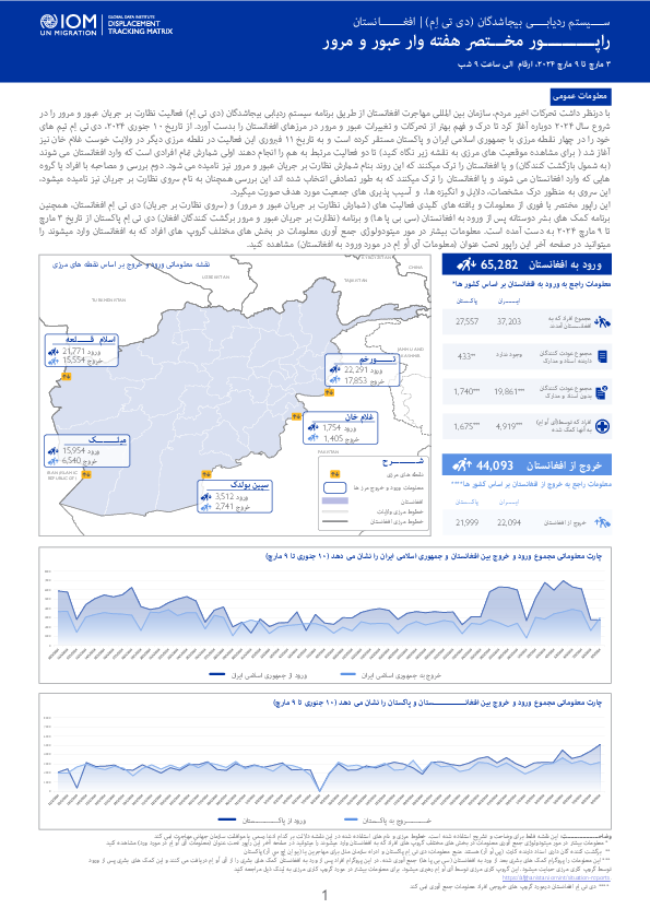
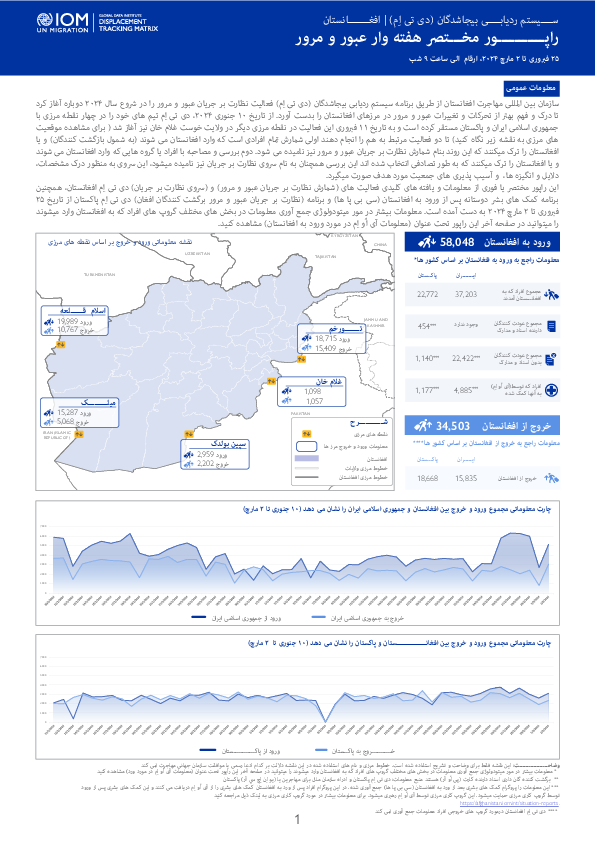
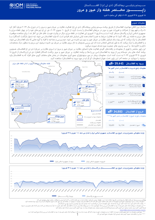
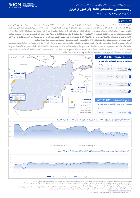
با درنظر داشت تحرکات اخیر مردم، سازمان بین المللی مهاجرت افغانستان از طریق برنامه سیستم ردیابی بیجاشدگان (دی تی اِم) فعالیت نظارت بر جریان عبور و مرور را در شروع سال ۲۰۲۴ دوباره آغاز کرد تا درک و فهم بهتر از تحرکات و تغییرات عبور و مرور در مرزهای افغانستان را بدست آورد.
سازمان بین المللی مهاجرت افغانستان از طریق برنامه سیستم ردیابی بیجاشدگان (دی تی اِم) فعالیت نظارت بر جریان عبور و مرور را در شروع سال ۲۰۲۴ دوباره آغاز کرد تا درک و فهم بهتر از تحرکات و تغییرات عبور و مرور در مرزهای افغانستان را بدست آورد.
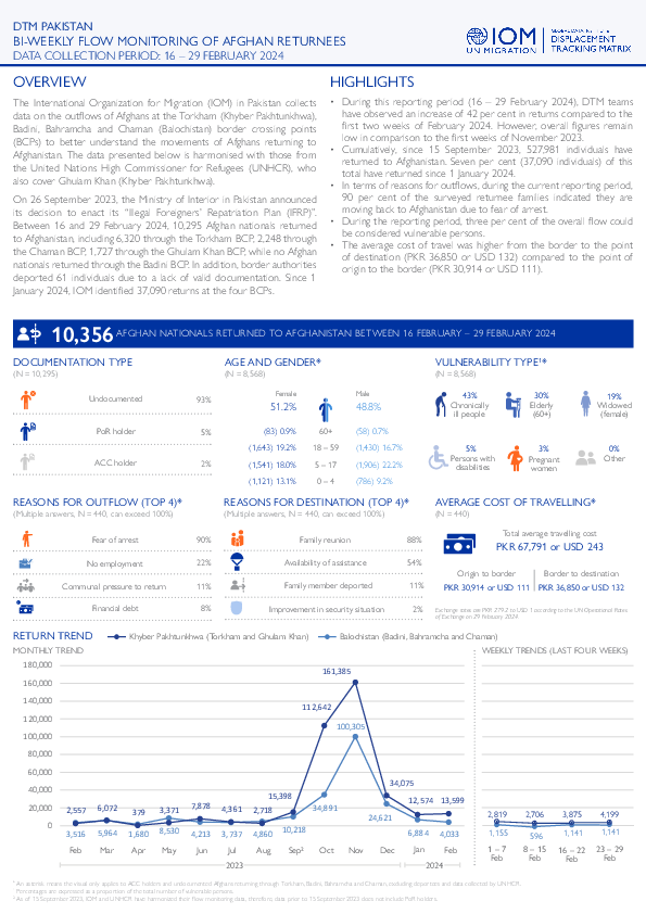
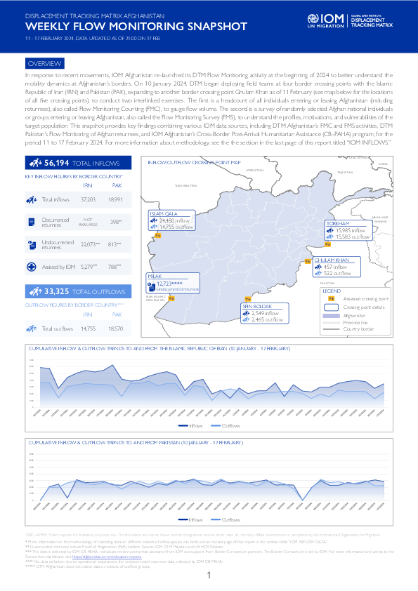
On 26 September 2023, the Ministry of Interior in Pakistan announced its decision to enact its “Illegal Foreigners’ Repatriation Plan (IFRP)”.
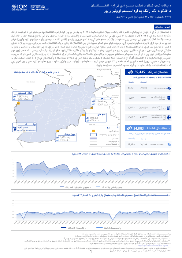
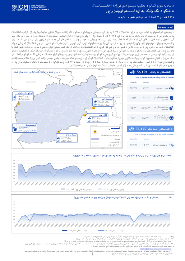
د افغانستان آی اُو اِم د (ډي تي اِم) پروګرام د خلکو د تګ راتګ د جریان څارنې فعالیت د ۲۰۲۴ په پیل کې بیا پیل کړل ترڅو د افغانستان په سرحدونو کې د خوځښت او تګ راتګ په اړه ښه پوه شي.

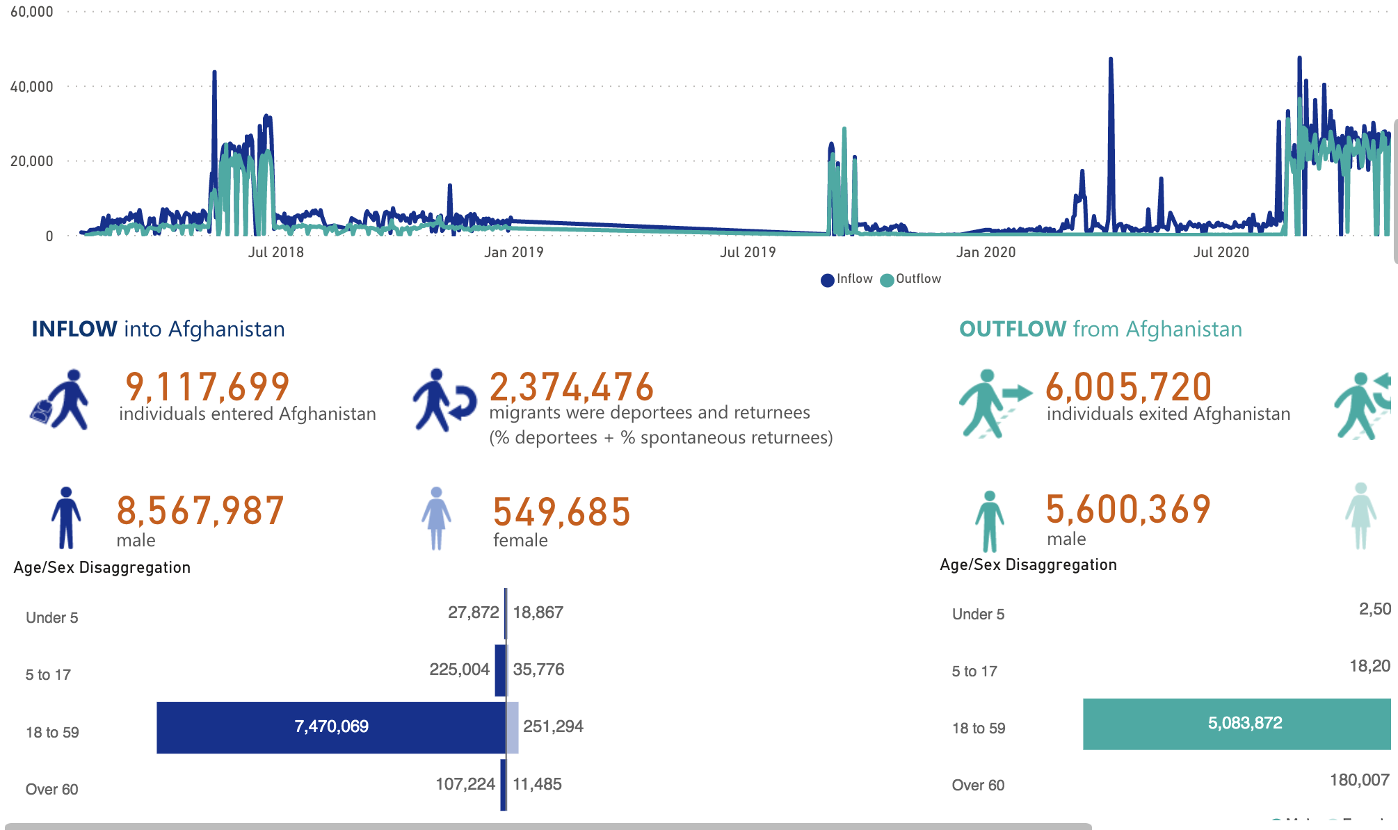
IOM Afghanistan's DTM Flow Monitoring activity, initiated at the beginning of 2024, seeks to quantify and better understand the mobility dynamics at Afghanistan’s borders.

From June to October 2022, storms and heavy monsoon rains in Pakistan caused widespread flooding and landslides across the country.
From June to October 2022, storms and heavy monsoon rains in Pakistan caused widespread flooding and landslides across the country.

This factsheet aims to provide a snapshot of multi-sectoral conditions, needs, and challenges among Myanmar migrants in Chumphon province as captured between December 2023 and February 2024 by IOM Thailand’s multi-sectoral assessment of needs.

This factsheet aims to provide a snapshot of multi-sectoral conditions, needs, and challenges among Myanmar migrants in Chiang Rai province as captured between December 2023 and February 2024 by IOM Thailand’s multi-sectoral assessment of needs.
سازمان بین المللی مهاجرت افغانستان از طریق برنامه سیستم ردیابی بیجاشدگان (دی تی اِم) فعالیت نظارت بر جریان عبور و مرور را در شروع سال ۲۰۲۴ دوباره آغاز کرد تا درک و فهم بهتر از تحرکات و تغییرات عبور و مرور در مرزهای افغانستان را بدست آورد.
د افغانستان آی اُو اِم د (ډي تي اِم) پروګرام د خلکو د تګ راتګ د جریان څارنې فعالیت د ۲۰۲۴ په پیل کې بیا پیل کړل ترڅو د افغانستان په سرحدونو کې د خوځښت او تګ راتګ په اړه ښه پوه شي.
IOM Afghanistan's DTM Flow Monitoring activity, initiated at the beginning of 2024, seeks to quantify and better understand the mobility dynamics at Afghanistan’s borders.

On 26 September 2023, the Ministry of Interior in Pakistan announced its decision to enact its “Illegal Foreigners’ Repatriation Plan (IFRP)”.

In response to recent movements, IOM Afghanistan re-launched its DTM Flow Monitoring activity at the beginning of 2024 to better understand the mobility dynamics at Afghanistan’s borders.
با درنظر داشت تحرکات اخیر مردم، سازمان بین المللی مهاجرت افغانستان از طریق برنامه سیستم ردیابی بیجاشدگان خود فعالیت نظارت بر جریان عبور و مرور را در شروع سال ۲۰۲۴ دوباره آغاز کرد تا تحرکات و تغییرات عبور و مرور در مرزهای افغانستان را بهتر درک کند.

د وروستیو خوځښتونو په ځواب کې، آی اُو اِم افغانستان د ۲۰۲۴ په پیل کې د ډِی ټِی اِم پروګرام د خلکو د تګ راتګ د جریان څارنې فعالیت بیا پیل کړل ترڅو د افغانستان په سرحدونو کې د خوځښت او تګ راتګ په اړه ښه پوه شي.
On 26 September 2023, the Ministry of Interior in Pakistan announced its decision to enact its “Illegal Foreigners’ Repatriation Plan (IFRP)”.
In response to recent movements, IOM Afghanistan re-launched its DTM Flow Monitoring activity at the beginning of 2024 to better understand the mobility dynamics at Afghanistan’s borders.

با درنظر داشت تحرکات اخیر مردم، سازمان بین المللی مهاجرت افغانستان از طریق برنامه سیستم ردیابی بیجاشدگان خود فعالیت نظارت بر جریان عبور و مرور را در شروع سال ۲۰۲۴ دوباره آغاز کرد تا تحرکات و تغییرات عبور و مرور در مرزهای افغانستان را بهتر درک کند.

د وروستیو خوځښتونو په ځواب کې، آی اُو اِم افغانستان د ۲۰۲۴ په پیل کې د ډي ټي اِم پروګرام د خلکو د تګ راتګ د جریان څارنې فعالیت بیا پیل کړل ترڅو د افغانستان په سرحدونو کې د خوځښت او تګ راتګ په اړه ښه پوه شي.

This factsheet aims to provide a snapshot of multi-sectoral conditions, needs, and challenges among Myanmar migrants in Chiang Mai province as captured between October 2023 and January 2024 by IOM Thailand’s multi-sectoral assessment of needs.

د وروستیو خوځښتونو په ځواب کې، آی اُو اِم افغانستان د ۲۰۲۴ په پیل کې د ډِی ټِی اِم پروګرام د خلکو د تګ راتګ د جریان څارنې فعالیت بیا پیل کړل ترڅو د افغانستان په سرحدونو کې د خوځښت او تګ راتګ په اړه ښه پوه شي.

In response to recent movements, IOM Afghanistan re-launched its DTM Flow Monitoring activity at the beginning of 2024 to better understand the mobility dynamics at Afghanistan’s borders.

با درنظر داشت تحرکات اخیر مردم، سازمان بین المللی مهاجرت افغانستان از طریق برنامه سیستم ردیابی بیجاشدگان خود فعالیت نظارت بر جریان عبور و مرور را در شروع سال ۲۰۲۴ دوباره آغاز کرد تا تحرکات و تغییرات عبور و مرور در مرزهای افغانستان را بهتر درک کند.
Afghanistan - Baseline Assessment, Settlement Level, Round 15 (March-April 2022)
Jul 14 2022
A baseline assessment is a sub-component of mobility tracking. It aims to collect data on IDP, migrant and returnee population presence in a defined administrative area of the country. This dataset contains information by settlement. Settlement is the lowest unit of observation used in Afghanistan.
Afghanistan - Baseline Assessment, District Level, Round 15 (March-April 2022)
Jul 07 2022
A baseline assessment is a sub-component of mobility tracking. It aims to collect data on IDP, migrant and returnee population presence in a defined administrative area of the country. This dataset presents a summary at the district level of data collected by DTM in Afghanistan.
Thailand — COVID-19 Vaccine Perceptions of Cambodian and Myanmar Migrants in Thailand (April 2022)
Apr 22 2022
From mid-November 2021 to mid-February 2022, a total of 4,429 surveys were collected among Cambodian and Myanmar migrants in the provinces of Chanthaburi, Chonburi, Ranong, Rayong, Tak, Trat, and Greater Bangkok Area. The findings help to identify attitudes and perceptions on COVID-19 vaccination,…
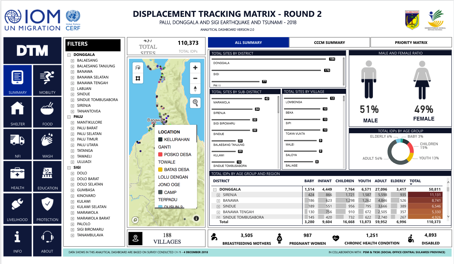
Afghanistan - Community Based Needs Assessment, Round 14 (Nov-Dec 2021)
Mar 02 2022
A Community-Based Needs Assessment (CBNA), intended as an integral component of DTM's Baseline Mobility Assessment to provide a more comprehensive view of multi-sectoral needs in settlements hosting IDPs and returnees.
Afghanistan - Baseline Assessment Settlement Round 14
Mar 02 2022
A baseline assessment is a sub-component of mobility tracking. It aims to collect data on IDP, migrant or returnee population presence in a defined administrative area of the country. This dataset contains information by settlement. Settlement is the lowest unit of observation used in Afghanistan
Afghanistan - Baseline Assessment District Round 14
Mar 02 2022
A baseline assessment is a sub-component of mobility tracking. It aims to collect data on IDP, migrant or returnee population presence in a defined administrative area of the country. This dataset presents a summary at the district level of data collected by DTM in Afghanistan.
Afghanistan - Community Based Needs Assessment (January—March 2021)
Jun 30 2021
A Community-Based Needs Assessment (CBNA), intended as an integral component of DTM's Baseline Mobility Assessment to provide a more comprehensive view of multi-sectoral needs in settlements hosting IDPs and returnees.
Afghanistan - Community Based Needs Assessment (July—December 2020)
Feb 05 2021
A Community-Based Needs Assessment (CBNA), intended as an integral component of DTM's Baseline Mobility Assessment to provide a more comprehensive view of multi-sectoral needs in settlements hosting IDPs and returnees.
Afghanistan - Community Based Needs Assessment (April—June 2021)
Sep 15 2021
A Community-Based Needs Assessment (CBNA), intended as an integral component of DTM's Baseline Mobility Assessment to provide a more comprehensive view of multi-sectoral needs in settlements hosting IDPs and returnees.
Afghanistan - Baseline Assessment Settlement Round 13
Sep 15 2021
A baseline assessment is a sub-component of mobility tracking. It aims to collect data on IDP, migrant or returnee population presence in a defined administrative area of the country. This dataset contains information by settlement. Settlement is the lowest unit of observation used in Afghanistan
Afghanistan - Baseline Assessment District Round 13
Sep 15 2021
A baseline assessment is a sub-component of mobility tracking. It aims to collect data on IDP, migrant or returnee population presence in a defined administrative area of the country. This dataset presents a summary at the district level of data collected by DTM in Afghanistan.
Philippines — Maguindanao Displacement - Site Assessment - April 2021 — Round 1
Oct 18 2021
A site assessment is a sub-component of mobility tracking. It aims to collect data on population presence, living conditions and needs in a particular displacement site or community.
Afghanistan - Baseline Assessment District Round 12
Jun 01 2021
A baseline assessment is a sub-component of mobility tracking. It aims to collect data on IDP, migrant or returnee population presence in a defined administrative area of the country. This dataset presents a summary at the district level of data collected by DTM in Afghanistan.
Afghanistan - Baseline Assessment Settlement Round 12
Jun 01 2021
A baseline assessment is a sub-component of mobility tracking. It aims to collect data on IDP, migrant or returnee population presence in a defined administrative area of the country. This dataset contains information by settlement. Settlement is the lowest unit of observation used in Afghanistan
Afghanistan — Baseline Mobility Assessment Summary Results (January—March 2021)
Jun 01 2021
A baseline assessment is a sub-component of mobility tracking. It aims to collect data on IDP, migrant or returnee population presence in a defined administrative area of the country. This dataset presents a summary at the district level of data collected by DTM in Afghanistan.
Afghanistan - Baseline Assessment Settlement Round 11
May 02 2021
A baseline assessment is a sub-component of mobility tracking. It aims to collect data on IDP, migrant or returnee population presence in a defined administrative area of the country. This dataset contains information by settlement. Settlement is the lowest unit of observation used in Afghanistan
Afghanistan - Baseline Assessment District Round 11
May 02 2021
A baseline assessment is a sub-component of mobility tracking. It aims to collect data on IDP, migrant or returnee population presence in a defined administrative area of the country. This dataset presents a summary at the district level of data collected by DTM in Afghanistan.
Afghanistan - Community Based Needs Assessment (January—June 2020)
Oct 01 2020
The Community-Based Needs Assessment (CBNA), an integral component of DTM's Baseline Mobility Assessment, provides a more comprehensive view of multi-sectoral needs in settlements hosting IDPs and returnees.
Afghanistan - Baseline Assessment Settlement Round 10
Nov 03 2020
A baseline assessment is a sub-component of mobility tracking. It aims to collect data on IDP, migrant or returnee population presence in a defined administrative area of the country. This dataset contains information by settlement. Settlement is the lowest unit of observation used in Afghanistan
Afghanistan - Baseline Assessment District Round 10
Nov 03 2020
A baseline assessment is a sub-component of mobility tracking. It aims to collect data on IDP, migrant or returnee population presence in a defined administrative area of the country. This dataset presents a summary at the district level of data collected by DTM in Afghanistan.
This map provides information on individuals who do not have access to latrines in villages assessed under Community Based Needs Assessment during the period from 2012 through December 2021.

This map provides information on inaccessibility of clinics in villages assessed under Community Based Needs Assessment during the period from 2012 through December 2021.
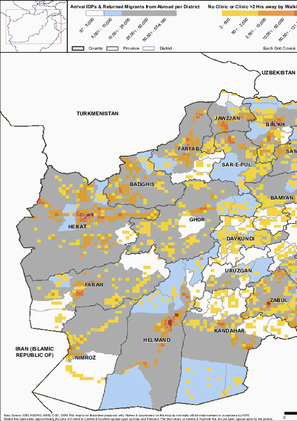
This map provides information on level of confidence in justice system in villages assessed under Community Based Needs Assessment during the period from 2012 through December 2021.
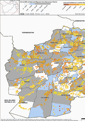
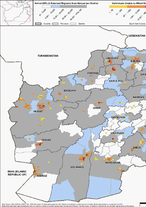
This map provides information on individuals unable to afford rent in villages assessed under Community Based Needs Assessment during the period from 2012 through December 2021.
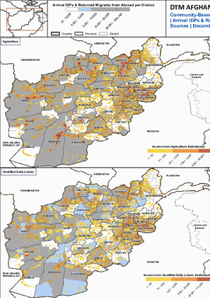
This map provides information on income from unskilled daily labour in villages assessed under Community Based Needs Assessment during the period from 2012 through December 2021.

This map provides information on income from unskilled daily labour in villages assessed under Community Based Needs Assessment during the period from 2012 through December 2021.

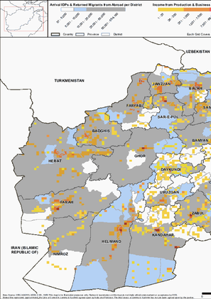
This map provides information on income from production sources and businesses in villages assessed under Community Based Needs Assessment during the period from 2012 through December 2021.
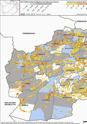
This map provides information on income from livestock sources in villages assessed under Community Based Needs Assessment during the period from 2012 through December 2021.
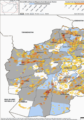
This map provides information on income from agriculture sources in villages assessed under Community Based Needs Assessment during the period from 2012 through December 2021.
This map provides information on Top 4 income sources of villages assessed under Community Based Needs Assessment during the period from 2012 through December 2021.
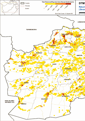
This map provides information on Returned Migrants from Abroad, Afghans who had fled abroad for at least 6 months and have now returned to Afghanistan, during the period from 2012 through December 2021.
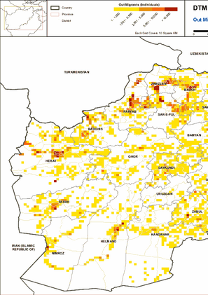
This map provides information on Out Migrants (Afghans who moved or fled abroad) During period of 2012 till December 2021.
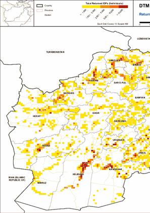
This map provides information on Returned IDPs (Afghans from an assessed village who had fled as IDPs in the past and have now returned home) During period of 2012 till December 2021.
This map provides information on Arrival IDPs (IDPs from other location currently residing in an assessed village) during period of 2012 till December 2021.

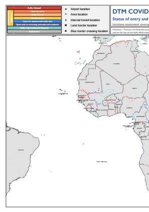
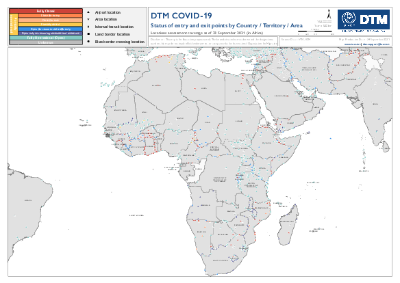
The current outbreak of COVID-19 has affected global mobility in complex and unprecedented ways in the form of various travel restrictions, suspension of air travel, and border closures. To better understand this, the International Organization for Migration (IOM) has developed a global mobility database to map these impacts on human mobility, across global, regional, and country levels. Furthermore, COVID-19 has had a disproportionate impact on vulnerable populations in camps and camp-like settings as well as exacerbated the vulnerabilities of mobile populations who may now be stranded owing to COVID-19 related mobility restrictions. This data is particularly important when addressing specific needs faced by migrants and mobile populations. IOM has developed a global mobility database mapping the status of different Points of Entry (PoE) and Key Locations of Internal Mobility, globally. These include airports, land border crossing points (could be rail or road), blue border crossing points (sea, river or lake), internal transit points, and areas of interest. For each point of entry, data is collected on the type of restriction, measured applied, and the timeframe, as well as the population category that may be affected by the restrictive measures. This workstream uses direct input from IOM missions and this dashboard displays regularly updated mobility restrictions at the location level.
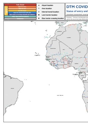
The current outbreak of COVID-19 has affected global mobility in complex and unprecedented ways in the form of various travel restrictions, suspension of air travel, and border closures. To better understand this, the International Organization for Migration (IOM) has developed a global mobility database to map these impacts on human mobility, across global, regional, and country levels. Furthermore, COVID-19 has had a disproportionate impact on vulnerable populations in camps and camp-like settings as well as exacerbated the vulnerabilities of mobile populations who may now be stranded owing to COVID-19 related mobility restrictions. This data is particularly important when addressing specific needs faced by migrants and mobile populations.IOM has developed a global mobility database mapping the status of different Points of Entry (PoE) and Key Locations of Internal Mobility, globally. These include airports, land border crossing points (could be rail or road), blue border crossing points (sea, river or lake), internal transit points, and areas of interest. For each point of entry, data is collected on the type of restriction, measured applied, and the timeframe, as well as the population category that may be affected by the restrictive measures. This workstream uses direct input from IOM missions and this dashboard displays regularly updated mobility restrictions at the location level.
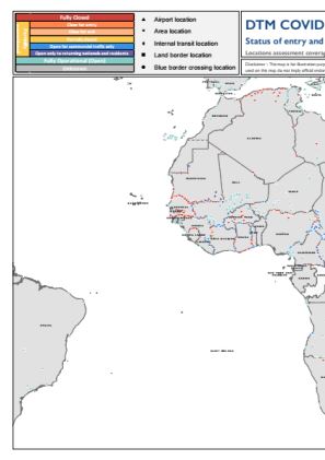
The current outbreak of COVID-19 has affected global mobility in complex and unprecedented ways in the form of various travel restrictions, suspension of air travel, and border closures. To better understand this, the International Organization for Migration (IOM) has developed a global mobility database to map these impacts on human mobility, across global, regional, and country levels. Furthermore, COVID-19 has had a disproportionate impact on vulnerable populations in camps and camp-like settings as well as exacerbated the vulnerabilities of mobile populations who may now be stranded owing to COVID-19 related mobility restrictions. This data is particularly important when addressing specific needs faced by migrants and mobile populations.IOM has developed a global mobility database mapping the status of different Points of Entry (PoE) and Key Locations of Internal Mobility, globally. These include airports, land border crossing points (could be rail or road), blue border crossing points (sea, river or lake), internal transit points, and areas of interest. For each point of entry, data is collected on the type of restriction, measured applied, and the timeframe, as well as the population category that may be affected by the restrictive measures. This workstream uses direct input from IOM missions and this dashboard displays regularly updated mobility restrictions at the location level.

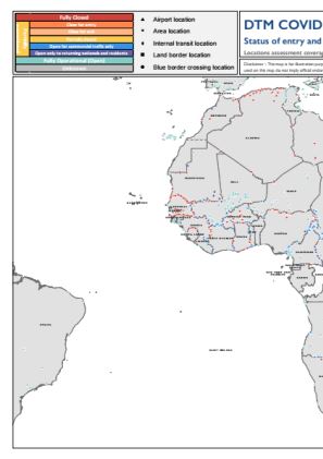
The current outbreak of COVID-19 has affected global mobility in complex and unprecedented ways in the form of various travel restrictions, suspension of air travel, and border closures. To better understand this, the International Organization for Migration (IOM) has developed a global mobility database to map these impacts on human mobility, across global, regional, and country levels. Furthermore, COVID-19 has had a disproportionate impact on vulnerable populations in camps and camp-like settings as well as exacerbated the vulnerabilities of mobile populations who may now be stranded owing to COVID-19 related mobility restrictions. This data is particularly important when addressing specific needs faced by migrants and mobile populations.IOM has developed a global mobility database mapping the status of different Points of Entry (PoE) and Key Locations of Internal Mobility, globally. These include airports, land border crossing points (could be rail or road), blue border crossing points (sea, river or lake), internal transit points, and areas of interest. For each point of entry, data is collected on the type of restriction, measured applied, and the timeframe, as well as the population category that may be affected by the restrictive measures. This workstream uses direct input from IOM missions and this dashboard displays regularly updated mobility restrictions at the location level.

The current outbreak of COVID-19 has affected global mobility in complex and unprecedented ways in the form of various travel restrictions, suspension of air travel, and border closures. To better understand this, the International Organization for Migration (IOM) has developed a global mobility database to map these impacts on human mobility, across global, regional, and country levels. Furthermore, COVID-19 has had a disproportionate impact on vulnerable populations in camps and camp-like settings as well as exacerbated the vulnerabilities of mobile populations who may now be stranded owing to COVID-19 related mobility restrictions. This data is particularly important when addressing specific needs faced by migrants and mobile populations.IOM has developed a global mobility database mapping the status of different Points of Entry (PoE) and Key Locations of Internal Mobility, globally. These include airports, land border crossing points (could be rail or road), blue border crossing points (sea, river or lake), internal transit points, and areas of interest. For each point of entry, data is collected on the type of restriction, measured applied, and the timeframe, as well as the population category that may be affected by the restrictive measures. This workstream uses direct input from IOM missions and this dashboard displays regularly updated mobility restrictions at the location level.

The current outbreak of COVID-19 has affected global mobility in complex and unprecedented ways in the form of various travel restrictions, suspension of air travel, and border closures. To better understand this, the International Organization for Migration (IOM) has developed a global mobility database to map these impacts on human mobility, across global, regional, and country levels. Furthermore, COVID-19 has had a disproportionate impact on vulnerable populations in camps and camp-like settings as well as exacerbated the vulnerabilities of mobile populations who may now be stranded owing to COVID-19 related mobility restrictions. This data is particularly important when addressing specific needs faced by migrants and mobile populations.IOM has developed a global mobility database mapping the status of different Points of Entry (PoE) and Key Locations of Internal Mobility, globally. These include airports, land border crossing points (could be rail or road), blue border crossing points (sea, river or lake), internal transit points, and areas of interest. For each point of entry, data is collected on the type of restriction, measured applied, and the timeframe, as well as the population category that may be affected by the restrictive measures. This workstream uses direct input from IOM missions and this dashboard displays regularly updated mobility restrictions at the location level.
The current outbreak of COVID-19 has affected global mobility in complex and unprecedented ways in the form of various travel restrictions, suspension of air travel, and border closures. To better understand this, the International Organization for Migration (IOM) has developed a global mobility database to map these impacts on human mobility, across global, regional, and country levels. Furthermore, COVID-19 has had a disproportionate impact on vulnerable populations in camps and camp-like settings as well as exacerbated the vulnerabilities of mobile populations who may now be stranded owing to COVID-19 related mobility restrictions. This data is particularly important when addressing specific needs faced by migrants and mobile populations.IOM has developed a global mobility database mapping the status of different Points of Entry (PoE) and Key Locations of Internal Mobility, globally. These include airports, land border crossing points (could be rail or road), blue border crossing points (sea, river or lake), internal transit points, and areas of interest. For each point of entry, data is collected on the type of restriction, measured applied, and the timeframe, as well as the population category that may be affected by the restrictive measures. This workstream uses direct input from IOM missions and this dashboard displays regularly updated mobility restrictions at the location level.
The current outbreak of COVID-19 has affected global mobility in complex and unprecedented ways in the form of various travel restrictions, suspension of air travel, and border closures. To better understand this, the International Organization for Migration (IOM) has developed a global mobility database to map these impacts on human mobility, across global, regional, and country levels. Furthermore, COVID-19 has had a disproportionate impact on vulnerable populations in camps and camp-like settings as well as exacerbated the vulnerabilities of mobile populations who may now be stranded owing to COVID-19 related mobility restrictions. This data is particularly important when addressing specific needs faced by migrants and mobile populations.IOM has developed a global mobility database mapping the status of different Points of Entry (PoE) and Key Locations of Internal Mobility, globally. These include airports, land border crossing points (could be rail or road), blue border crossing points (sea, river or lake), internal transit points, and areas of interest. For each point of entry, data is collected on the type of restriction, measured applied, and the timeframe, as well as the population category that may be affected by the restrictive measures. This workstream uses direct input from IOM missions and this dashboard displays regularly updated mobility restrictions at the location level.

The current outbreak of COVID-19 has affected global mobility in complex and unprecedented ways in the form of various travel restrictions, suspension of air travel, and border closures. To better understand this, the International Organization for Migration (IOM) has developed a global mobility database to map these impacts on human mobility, across global, regional, and country levels. Furthermore, COVID-19 has had a disproportionate impact on vulnerable populations in camps and camp-like settings as well as exacerbated the vulnerabilities of mobile populations who may now be stranded owing to COVID-19 related mobility restrictions. This data is particularly important when addressing specific needs faced by migrants and mobile populations.IOM has developed a global mobility database mapping the status of different Points of Entry (PoE) and Key Locations of Internal Mobility, globally. These include airports, land border crossing points (could be rail or road), blue border crossing points (sea, river or lake), internal transit points, and areas of interest. For each point of entry, data is collected on the type of restriction, measured applied, and the timeframe, as well as the population category that may be affected by the restrictive measures. This workstream uses direct input from IOM missions and this dashboard displays regularly updated mobility restrictions at the location level.

The current outbreak of COVID-19 has affected global mobility in complex and unprecedented ways in the form of various travel restrictions, suspension of air travel, and border closures. To better understand this, the International Organization for Migration (IOM) has developed a global mobility database to map these impacts on human mobility, across global, regional, and country levels. Furthermore, COVID-19 has had a disproportionate impact on vulnerable populations in camps and camp-like settings as well as exacerbated the vulnerabilities of mobile populations who may now be stranded owing to COVID-19 related mobility restrictions. This data is particularly important when addressing specific needs faced by migrants and mobile populations.IOM has developed a global mobility database mapping the status of different Points of Entry (PoE) and Key Locations of Internal Mobility, globally. These include airports, land border crossing points (could be rail or road), blue border crossing points (sea, river or lake), internal transit points, and areas of interest. For each point of entry, data is collected on the type of restriction, measured applied, and the timeframe, as well as the population category that may be affected by the restrictive measures. This workstream uses direct input from IOM missions and this dashboard displays regularly updated mobility restrictions at the location level.