Sep 25 2022
- Mobility Tracking
- Event Tracking
The DTM Emergency Tracking Tool (ETT) is deployed to track and to collect information on large and sudden population movements, provide frequent updates on the scale of displacement and quantify the affected population when needed. As a sub-component of the Mobility Tracking methodology in Nigeria, ETT utilises direct observation and a broad network of key informants to capture best estimates of the affected population per location, enabling targeted humanitarian response planning.
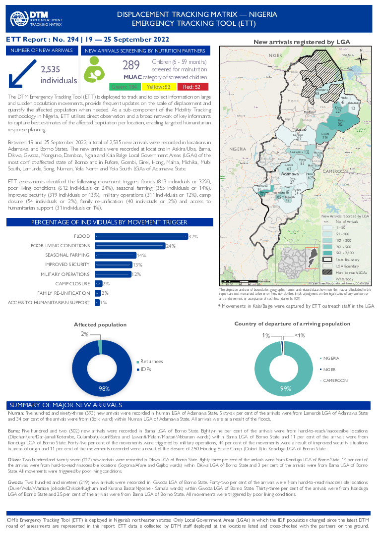
Between 19 and 25 September 2022, a total of 2,535 new arrivals were recorded in locations in Adamawa and Borno States. The new arrivals were recorded at locations in Askira/Uba, Bama, Dikwa, Gwoza, Monguno, Damboa, Ngala and Kala Balge Local Government Areas (LGAs) of the most conflict-affected state of Borno and in Fufore, Gombi, Girei, Hong, Maiha, Michika, Mubi South, Lamurde, Song, Numan, Yola North and Yola South LGAs of Adamawa State.
Sep 23 2022
- Mobility Tracking
- Event Tracking
Following agro-pastoralist clashes, which occurred between 12 and 13 September 2022 in the département of Lac Iro (Moyen Chari province), 600 households (3,667 individuals) were displaced from the cantons of Ngoundé, Singakoh and Ballet (Département of Lac Iro), to seek refuge in the town of Kyabé (the capital of the département of Lac Iro) on foot and by truck. In addition to displacement, these clashes caused considerable damage to houses, millet, peanuts and rice fields incurred, the death of 48 individuals and the loss of non-food items and personal valuables.
Sep 23 2022
- Mobility Tracking
- Event Tracking
Suite aux affrontements agro-éleveurs, survenus entre les 12 et 13 septembre 2022 dans le département de Lac Iro (province du Moyen Chari), 600 ménages (3 667 individus) se sont déplacés des cantons de Ngoundé, Singakoh et Ballet (département de Lac Iro) vers la ville de Kyabé (chef-lieu du département de Lac Iro) à pied et en camion. En plus des déplacements, ces affrontements ont causé des dégâts importants aux maisons, aux champs de mils, arachides, riz et engendré les pertes de 48 vies humaines, des articles non alimentaires et d’autres biens des ménages.

To better understand and capture how COVID-19 has been affecting global mobility, IOM developed a global database (the Mobility Restriction Monitoring, MRM) which maps, tracks, and analyses the changes and trends in operational status of and mobility restrictions at Points of Entry (PoEs) including airports, blue border crossing points (such as seaports and river crossings), land border crossing points and other key transit points and locations of internal mobility. Outside of operational status for key loca- tions of internal mobility, MRM collects data on border management and public health measures adopted at PoEs, as well as coordination systems and referral mechanisms in place at Points of Entry and some internal mobility points, as well as populations impacted by COVID-19 mobility restrictions.
Such information is meant to serve IOM member states, IOM, and its UN partner agencies in responding adequately, and in a targeted manner, to the current and evol- ving crisis period. In West and Central Africa, IOM missions were involved in providing information on the situation at the PoEs in their respective countries.
This report presents the findings from data collected on the operational status of PoEs as of 30 June 2022, with 573 Points of Entry across the region, including 417 land border crossings points, 74 airports and 82 blue border crossing points (maritime borders).
Sep 24 2022
- Mobility Tracking
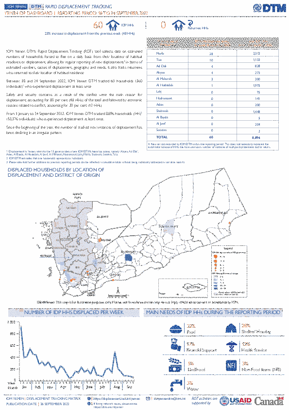
IOM Yemen DTM’s Rapid Displacement Tracking (RDT) tool collects data on estimated numbers of households forced to flee on a daily basis from their locations of origin or displacement, allowing for regular reporting of new displacements in terms of estimated numbers, geography, and needs. It also tracks returnees who returned to their location of origin.
From 1 January to 24 September 2022, IOM Yemen DTM tracked 8,896 households (HH) (53,376 Individuals) who experienced displacement at least once.
Between 18 and 24 September 2022, IOM Yemen DTM tracked 60 households (360 individuals) displaced at least once. The majority of people moved into/within the following governorates and districts:
- Marib (38 HHs) – Marib City (34 HHs), Marib (4 HHs) districts. Most displacements in the governorate originated from Shabwah and Taiz.
- Taiz (10 HHs) – Jabal Habashi (7 HHs), Al Misrakh (2 HHs), Al Makha (1 HHs) districts. Most displacements in the governorate originated from Taiz and Sanaa City.
- Abyan (4 HHs) – Khanfar (4 HHs) district. All displacements in the governorate originated from Al Hodeidah.
The majority of people moved from the following governorates and districts:
- Taiz (14 HHs) – Maqbanah (6 HHs), Sabir Al Mawadim (4 HHs), Jabal Habashi (2 HHs) districts.
- Al Hodeidah (10 HHs) – Zabid (4 HHs), Al Marawiah (2 HHs), Al Jarrahi (2 HHs) districts.
- Shabwah (10 HHs) – Ataq (10 HHs) district.
- Mobility Tracking
- Baseline Assessment
Sep 07 2022
Population Groups
Survey Methodology
Unit of Analysis Or Observation
Type of Survey or Assessment
Keywords
Geographical Scope
Administrative boundaries with available data
The current dataset covers the following administrative boundaries

IOM works with national and local authorities in order to gain a better understanding of population movements throughout Southern Africa. Through the setup of Flow Monitoring Points (FMPs), IOM seeks to quantify migration flows, trends and routes and to gain a better understanding of the profiles of observed individuals at entry, transit or exit points (such as border crossing posts, bus stations, rest areas, police checkpoints and reception centres). This report is an overview of the data collected in these FMPs from 1 to 31 August 2022.
Inter-regional migration from and within the Southern Africa is categorized along the following corridors. The Flow Monitoring Points (FMPs) were set-up in several key transit locations along the corridors to track the movements of passengers:
•Zimbabwe (Mutare) – Mozambique (Manica)
•Zimbabwe – Zambia (Chirundu)
•Zimbabwe – Botswana (Plumtree)
•Zimbabwe (Beitbridge) – South Africa
•Malawi (Mchinji) - Zambia (Mwami)
•Malawi (Karonga ) – United Republic of Tanzania
•Malawi (Mwanza) – Mozambique (Zobue)
•Malawi (Mulanje) – Mozambique
•Mozambique (Ressano Garcia) – South Africa
•Democratic Republic of the Congo (Kasumbalesa) – Zambia
Over the reporting period a total of 76,756 movements were observed across 48 FMPs in the region. The Zimbabwe – South Africa corridor hosted the largest number of movements with 33,123 (43%) followed by the Democratic Republic of Congo (Kasumbalesa) – Zambia corridor with 11,566 (15%) and the (Malawi (Mwanza) – Mozambique (Zobue) corridor with 9,775 movements reported (13%).
Aug 31 2022
- Flow Monitoring
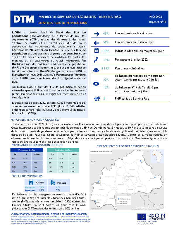
Afin de mieux comprendre les mouvements et tendances migratoires en Afrique de l’Ouest et du Centre, l’OIM, à travers la Matrice de suivi des déplacements (Displacement Tracking Matrix, DTM), met en œuvre l’activité de Suivi des flux de populations (Flow Monitoring, FM).
Au Burkina Faso, la DTM recueille des données au niveau de 4 Points de suivi des flux (Flow Monitoring Points, FMP) que sont Dori/Seytenga, Kantchari, Faramana et Yendéré répartis dans 4 régions afin d’obtenir une meilleure compréhension de l’ampleur, des tendances, des caractéristiques socio-démographiques et des parcours des flux de voyageurs traversant ces différents points.
Ce rapport présente les données recueillies dans le cadre des activités d’enregistrement des flux durant le mois d'août 2022.
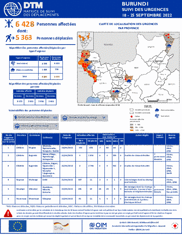
Sep 25 2022
- Mobility Tracking
- Event Tracking
La DTM a identifié 6 428 personnes (1 281 ménages) affectées dont 5 363 personnes (1 055 ménages) déplacées par les pluies torrentielles et vents violents dans les provinces de Cibitoke, Kayanza, Muramvya et Muyinga.