
Mar 31 2022
- Other
Falaba became a new district of Sierra Leone in 2016. The Faranah Prefecture is located immediately across the border in neighboring Guinea with Sierra Leone. Both areas are remote, hard-to-reach and sparsely populated, yet cross-border movement remains pronounced between these two locations. The district comprised mostly of cattle herding and farming as major economic and livelihood activities, and it is considered a rural district. Cross- border trade is also known of the district. In terms of the district ethnic composition, Mandigo, Fula, Yalunka and Kuranko are among the major tribes inhabiting the district, with Yalunka constituting the highest.
On the Guinea side the main ethnic groups represented are Djalonke, Kurankos, and Fulani, with the Kurankos and Yalunkas from the Sierra Leone side. The Fulani (Peulh) are semi-nomadic pastoralist people practicing free-range cattle herding. The other ethnic groups present in the regions on both sides are largely engaged in subsistence crop farming, cultivating rice, groundnut, hot pepper, and vegetables which is practiced by both men and women.
The border areas in Falaba and Faranah both attract a sizable volume of transhumance migration. With large mass of potential grazing land attainable, cattle herders are increasingly migrating from other districts in Sierra Leone and Guinea to Falaba. Concurrently, Faranah attracts herders from other Guinea’s prefectures and into Falaba in Sierra Leone for its grazing land.
Nov 10 2022
- Mobility Tracking
- Event Tracking
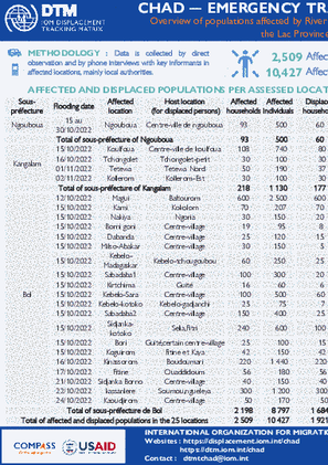
The objective of the Emergency Tracking Tool (ETT) is to collect information on large and sudden population movements as well as security and climatic emergencies This dashboard presents information on river floods that occurred in 25 localities in the Lac province, in October and November 2022. In these 25 assessed localities, a total of 2,509 households (10,427 individuals) were affected by these floods, of which 1,921 households (8,260 individuals) were displaced. This overview does not represent the complete situation of people affected by river flooding in the Lac province but only in the localities assessed. It should also be noted that the situation is very changing, given the rapid progression of the rising waters of Lake Chad. Updates will be progressively shared by DTM teams as data is collected. In addition, in-depth assessments are necessary in order to have a more precise view of the situation
Nov 10 2022
- Mobility Tracking
- Event Tracking
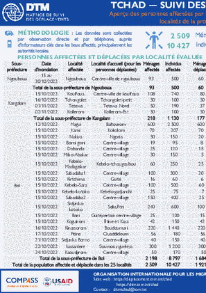
Le suivi des urgences a pour but de recueillir des informations sur les mouvements importants et soudains de populations ainsi que sur des urgences sécuritaires et climatiques. Chaque année au Tchad, durant la saison pluvieuse (Mai-Septembre), plusieurs localités sont souvent atteintes par des inondations, touchant des milliers de personnes. Ce tableau de bord présente les informations sur les inondations fluviales survenues en octobre 2022 dans 3 sous-préfectures de la province du Lac, affectant ainsi 1 351 ménages (5 837 individus). Ces informations ont été collectées à travers des entretiens téléphoniques avec les informateurs clés notamment les autorités locales dans la province affectée.
Suite à la montée des eaux du Lac Tchad survenue durant la période du 15 au 30 octobre 2022, 17 localités situées dans les sous-préfectures de Bol, Ngouboua et Kangalam (département de Kaya et Mamdi, province du Lac) ont été inondés. Au total, 1 351 ménages (5 837 individus) ont été affectés par ces inondations. Parmi ces personnes, 776 ménages (3 756 individus) se sont déplacés dans les mêmes sous-préfectures et accueillis par les membres de la communauté locale. Il est à indiquer que cette catastrophe a causé des dommages critiques aux habitations, aux 1378 hectares des champs des riz, maïs, mil et entrainé la perte de bétail. Ainsi, une assistance humanitaire d’urgence est nécessaire. Vu que, ces personnes vivent dans une situation d’extrême vulnérabilité et ont soulignés des besoins importants en abris, vivres et articles non alimentaires.

Haiti – Système D’alerte Précoce pour les Déplacements – Nouvelles arrivées (22 – 28 Octobre 2022)

Haiti – Système D’alerte Précoce pour les Déplacements – Nouveaux déplacements (22 – 28 Octobre 2022)
- Mobility Tracking
- Event Tracking
Nov 17 2022
Population Groups
Survey Methodology
Unit of Analysis Or Observation
Type of Survey or Assessment
Keywords
Geographical Scope
Administrative boundaries with available data
The current dataset covers the following administrative boundaries

Nov 06 2022
- Mobility Tracking
- Event Tracking
On 3rd of November, armed bandits reportedly attacked the communities Udar Yagba and Ukohol in Nyiev ward of Guma LGA in Benue State. The attacks affected 837 individuals, who were displaced to the communities Ortesy in Nyiev ward and Ndzorov in Ndzorov Council ward. As a result of the attacks, 15 fatalities and 36 injuries were reported.
On 5th of Novmber, armed bandits reportedly attacked the communities Udei and Yeluwata in Nyiev ward of Guma LGA in Benue State. The attacks affected 196 individuals, who were displaced to Ortesy IDP Camp in Nyiev ward. As a result of the attacks, 10 fatalities and 3 injuries were reported.

Nov 06 2022
- Mobility Tracking
- Event Tracking
The DTM Emergency Tracking Tool (ETT) is deployed to track and to collect information on large and sudden population movements, provide frequent updates on the scale of displacement and quantify the affected population when needed. As a sub-component of the Mobility Tracking methodology in Nigeria, ETT utilises direct observation and a broad network of key informants to capture best estimates of the affected population per location, enabling targeted humanitarian response planning.
Between 31 October and 06 November 2022, a total of 1,486 new arrivals were recorded in locations in Adamawa, Borno and Yobe States. The new arrivals were recorded at locations in Askira/Uba, Bama, Dikwa, Gwoza, Kala Balge, Monguno, and Ngala Local Government Areas (LGAs) of the most conflict-affected state of Borno, in Fufore, Girei, Gombi, Hong, Lamurde, Michika, Mubi South, Mubi North, Yola North, Yola South and Song LGAs of Adamawa and in Damaturu LGA of Yobe State.
Nov 04 2022
- Event Tracking
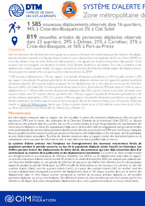
Une recrudescence des affrontements entre gangs rivaux, ainsi que l'éruption de manifestations parfois violentes, des pillages, pénuries de biens essentiels et le blocage d'axes routiers et ports dans la Zone métropolitaine de Port-au-Prince (ZMPP) au cours des derniers mois ont accrû l'insécurité déjà présente et ont aggravé une situation économique déjà précaire. Cette situation s'est accompagnée, ces dernières semaines, d'une flambée épidemique de choléra. Tout cela a contribué à des déplacements urbains à grande échelle.
Ce rapport présente les résultats de l'évaluation hebdomadaire des déplacements et de la situation humanitaire effectuée par le système d'alerte précoce du ZMPP. 1 585 nouveaux déplacements (-7% par rapport à la période d'évaluation précédente) et 819 nouvelles arrivées (-27% par rapport à la période d'évaluation précédente) de personnes déplacées internes ont été rapportés pendant la période d’évaluation dans les 303 quartiers évalués. La plupart de ces déplacements ont eu lieu dans les communes de Croix-des-Bouquets (94%), Cité Soleil (3%). Durant la période d’évaluation du 22 au 28 octobre, la DTM avait observé 1 699 nouveaux déplacements et 1 120 nouvelles arrivées de personnes déplacées dans 324 quartiers évalués.
La situation sécuritaire reste toujours tendue, avec 97 quartiers affectés par l'insécurité (-15% par rapport à la période d'évaluation précédente) et 46 par des violences généralisées (-27%). 31 quartiers (-18% par rapport à la période d'évaluation précédente) ont signalé une flambée épidémique de choléra dans le contexte de la résurgence des cas de choléra en Haïti, qui au 9 novembre 2022 avait conduit au décès de 144 personnes dans le pays. Quinze quartiers étaient situés à Cité Soleil, les autres étant situés à Port-au-Prince (9), Carrefour (2), Pétion-Ville (2), Delmas (2), et Tabarre (1).

Sep 30 2022
- Flow Monitoring
In September 2022, a total of 2,007 people were interviewed at four Flow Monitoring Points (FMPs) across the border between Uganda and Kenya. The majority of people interviewed were incoming to Uganda (57%) against outgoing to Kenya (43%).
More inflows were observed during the reporting period as compared to outflows across most flow monitoring points as illustrated in the map. Most people acquire information about jobs or business offers across the border from friends, relatives or community at their usual residences or at places of destination. The majority (56%) of outgoing movements are for economic reasons.