
Aug 31 2022
- Flow Monitoring
- Mobility Tracking
- Baseline Assessment
This infographic presents the key findings of Round 43 of the mobility tracking component of the Displacement Tracking Matrix (DTM) programme in Libya.

Aug 31 2022
- Mobility Tracking
- Baseline Assessment
IOM Libya’s Displacement Tracking Matrix (DTM) programme identified a total of 679,974 migrants from over 41 nationalities in the 100 Libyan municipalities during Round 43 of data collection (July - August 2022).
The number of migrants in Libya has continued to increase slightly compared to the previous reporting period (667,440 migrants, Round 42, June 2022) in line with a trend that started at the beginning of 2021. Prior to 2021 the number of migrants in Libya had been decreasing following the outbreak of the COVID-19 pandemic in 2020. The number of migrants in Libya identified during Round 43 is also higher than the number of migrants for the corresponding period in 2019 (636,426 migrants, Round 27, September 2019).
Nov 07 2022
- Other
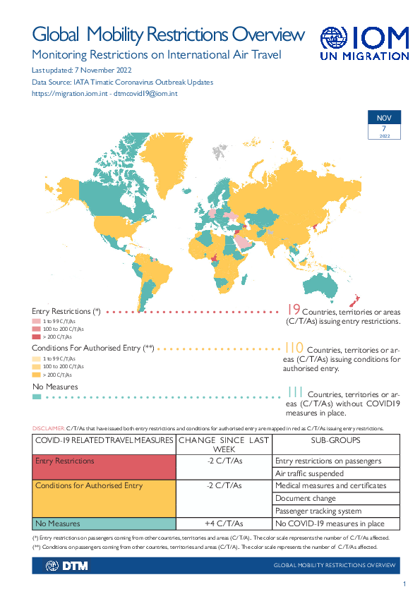
The DTM Global Mobility Restrictions Overview provides updates on international air travel restrictions and conditions for authorized entry. This overview aims to understand how COVID-19 has impacted human mobility, detailing how global and regional trends in air travel measures have evolved since COVID-19 was declared a global pandemic in March 2020. The data presented focuses on the changes in public health-related immigration and border management measures. It provides information intended to support IOM missions and partners in targeted response planning and advocacy for vulnerable populations who may be affected by changes in global mobility.
Nov 04 2022
- Flow Monitoring
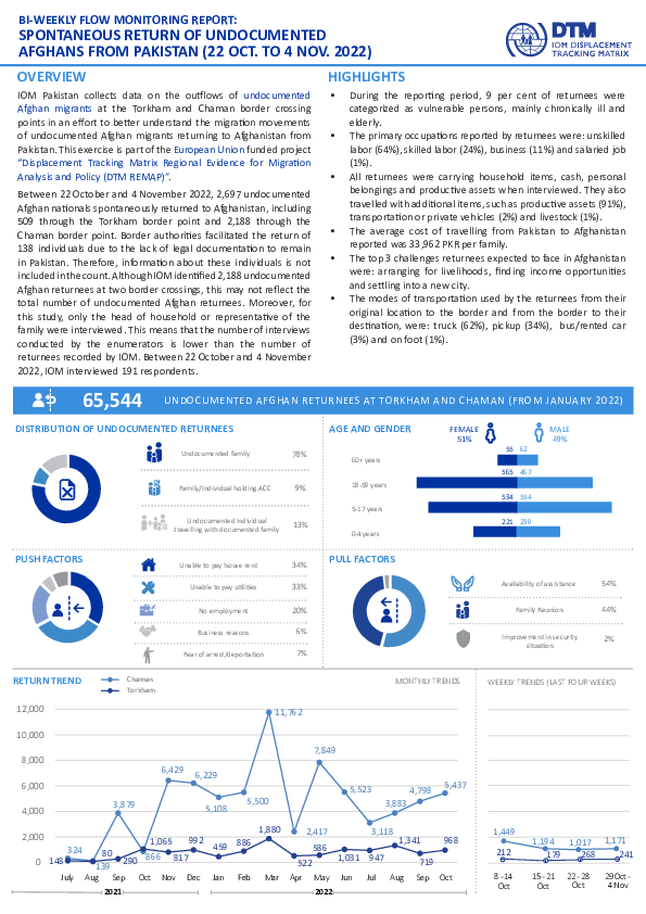
IOM Pakistan collects data on the outflows of undocumented Afghan migrants at the Torkham and Chaman border crossing points in an effort to better understand the migration movements of undocumented Afghan migrants returning to Afghanistan from Pakistan. This exercise is part of the European Union funded project “Displacement Tracking Matrix Regional Evidence for Migration Analysis and Policy (DTM REMAP)”.
Between 22 October and 4 November 2022, 2,697 undocumented Afghan migrants spontaneously returned to Afghanistan, including 509 through the Torkham border point and 2,188 through the Chaman border point. Border authorities facilitated the return of 138 individuals due to the lack of legal documentation to remain in Pakistan. Therefore, information about these individuals is not included in the count. Although IOM identified 2,188 undocumented Afghan returnees at two border crossings, this may not reflect the total number of undocumented Afghan returnees. Moreover, for this study, only the head of household or representative of the family were interviewed. This means that the number of interviews conducted by the enumerators is lower than the number of returnees recorded by IOM. Between 22 ctober and 4 November 2022, IOM interviewed 191 respondents.

Mar 31 2022
- Other
Falaba became a new district of Sierra Leone in 2016. The Faranah Prefecture is located immediately across the border in neighboring Guinea with Sierra Leone. Both areas are remote, hard-to-reach and sparsely populated, yet cross-border movement remains pronounced between these two locations. The district comprised mostly of cattle herding and farming as major economic and livelihood activities, and it is considered a rural district. Cross- border trade is also known of the district. In terms of the district ethnic composition, Mandigo, Fula, Yalunka and Kuranko are among the major tribes inhabiting the district, with Yalunka constituting the highest.
On the Guinea side the main ethnic groups represented are Djalonke, Kurankos, and Fulani, with the Kurankos and Yalunkas from the Sierra Leone side. The Fulani (Peulh) are semi-nomadic pastoralist people practicing free-range cattle herding. The other ethnic groups present in the regions on both sides are largely engaged in subsistence crop farming, cultivating rice, groundnut, hot pepper, and vegetables which is practiced by both men and women.
The border areas in Falaba and Faranah both attract a sizable volume of transhumance migration. With large mass of potential grazing land attainable, cattle herders are increasingly migrating from other districts in Sierra Leone and Guinea to Falaba. Concurrently, Faranah attracts herders from other Guinea’s prefectures and into Falaba in Sierra Leone for its grazing land.
Nov 10 2022
- Mobility Tracking
- Event Tracking
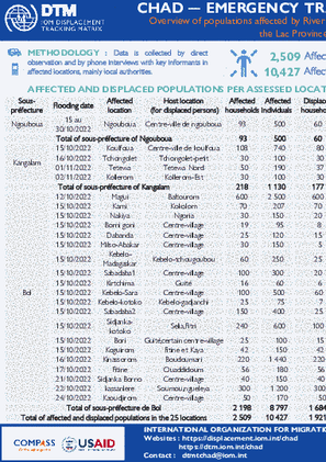
The objective of the Emergency Tracking Tool (ETT) is to collect information on large and sudden population movements as well as security and climatic emergencies This dashboard presents information on river floods that occurred in 25 localities in the Lac province, in October and November 2022. In these 25 assessed localities, a total of 2,509 households (10,427 individuals) were affected by these floods, of which 1,921 households (8,260 individuals) were displaced. This overview does not represent the complete situation of people affected by river flooding in the Lac province but only in the localities assessed. It should also be noted that the situation is very changing, given the rapid progression of the rising waters of Lake Chad. Updates will be progressively shared by DTM teams as data is collected. In addition, in-depth assessments are necessary in order to have a more precise view of the situation
Nov 10 2022
- Mobility Tracking
- Event Tracking
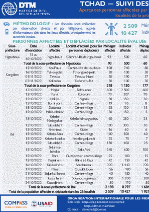
Le suivi des urgences a pour but de recueillir des informations sur les mouvements importants et soudains de populations ainsi que sur des urgences sécuritaires et climatiques. Chaque année au Tchad, durant la saison pluvieuse (Mai-Septembre), plusieurs localités sont souvent atteintes par des inondations, touchant des milliers de personnes. Ce tableau de bord présente les informations sur les inondations fluviales survenues en octobre 2022 dans 3 sous-préfectures de la province du Lac, affectant ainsi 1 351 ménages (5 837 individus). Ces informations ont été collectées à travers des entretiens téléphoniques avec les informateurs clés notamment les autorités locales dans la province affectée.
Suite à la montée des eaux du Lac Tchad survenue durant la période du 15 au 30 octobre 2022, 17 localités situées dans les sous-préfectures de Bol, Ngouboua et Kangalam (département de Kaya et Mamdi, province du Lac) ont été inondés. Au total, 1 351 ménages (5 837 individus) ont été affectés par ces inondations. Parmi ces personnes, 776 ménages (3 756 individus) se sont déplacés dans les mêmes sous-préfectures et accueillis par les membres de la communauté locale. Il est à indiquer que cette catastrophe a causé des dommages critiques aux habitations, aux 1378 hectares des champs des riz, maïs, mil et entrainé la perte de bétail. Ainsi, une assistance humanitaire d’urgence est nécessaire. Vu que, ces personnes vivent dans une situation d’extrême vulnérabilité et ont soulignés des besoins importants en abris, vivres et articles non alimentaires.

Haiti – Système D’alerte Précoce pour les Déplacements – Nouvelles arrivées (22 – 28 Octobre 2022)

Haiti – Système D’alerte Précoce pour les Déplacements – Nouveaux déplacements (22 – 28 Octobre 2022)
- Mobility Tracking
- Event Tracking
Nov 17 2022
Population Groups
Survey Methodology
Unit of Analysis Or Observation
Type of Survey or Assessment
Keywords
Geographical Scope
Administrative boundaries with available data
The current dataset covers the following administrative boundaries