Map
Displaying 61 - 80 of 989
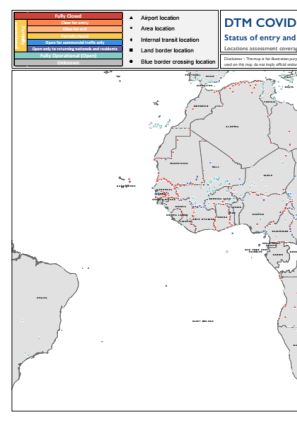
DTM COVID-19 Regional Atlas Point Operational Status as of 12 November 2020
The current outbreak of COVID19 has affected global mobility in complex and unprecedented ways in the form of various travel restrictions suspension of air travel and border closures To better understand this the International Organization for Migration IOM has developed a global mobility database to map these impacts on human mobility across global regional and country levels Furthermore COVID19…

Arrivals of displaced individuals in settlements
This map is representing an overview of arrivals of displaced indivials in settlements On the morning of 27 September renewed hostilities erupted in and around the NagornoKarabakh conflict zone This was the latest flare up in a conflict that has been ongoing for over thirty years On 9 November 2020 the Prime Minister of Armenia the President of Azerbaijan and the President of Russia announced…

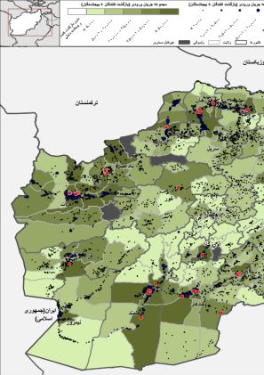
AFG_DTM_June2020_District_Fled_IDPs_Overview_By_District&Villages
This map provides information on Fled IDPs Afghans from an assessed village who fled as IDPs to reside elsewhere in Afghanistan During period of 2012 till June 2020

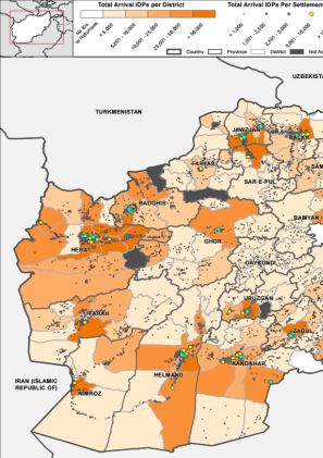
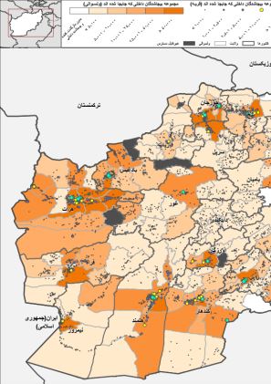
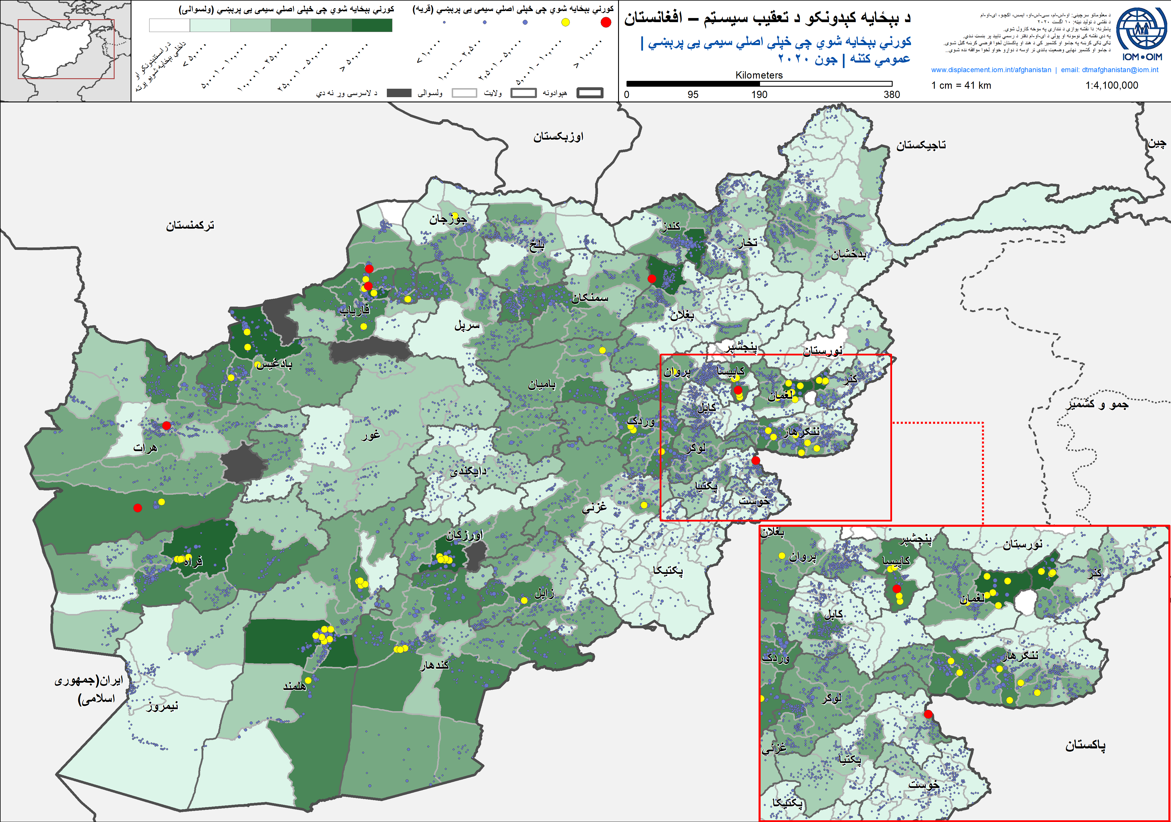
AFG_DTM_June2020_District_Arrival_IDPs_Overview_By_District&Villages
This map provides information on Arrival IDPs IDPs from other location currently residing in an assessed village during period of 2012 till June 2020
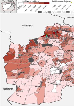
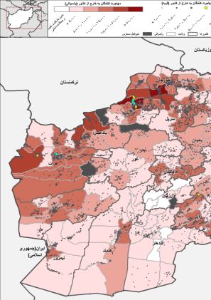
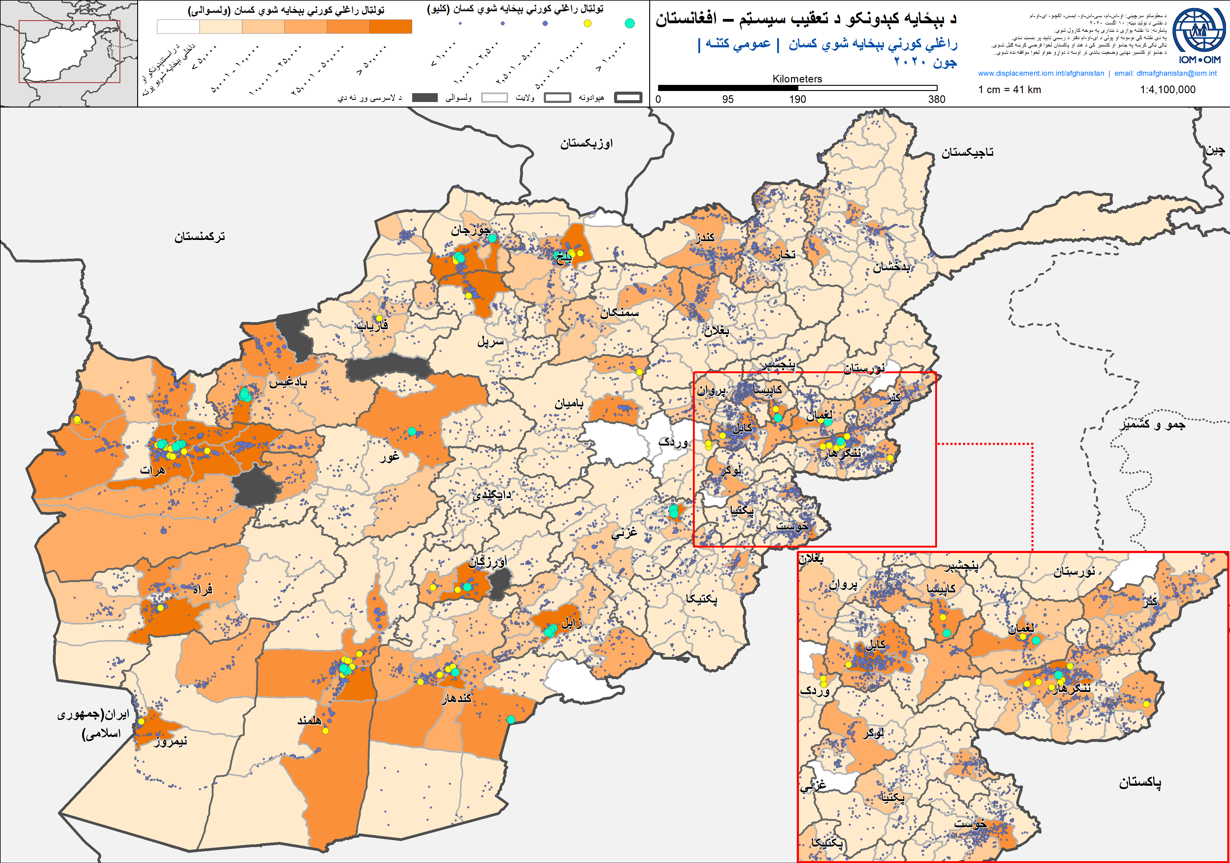
AFG_DTM_June2020_District_Out_Migrants_Overview_By_District&Villages
This map provides information on Out Migrants Afghans who moved or fled abroad During period of 2012 till June 2020
AFG_DTM_June2020_District_OutFlow_To_Europe_Overview_By_District&Villages
This map provides information on Outflow to Europe Afghans who moved to nonneighboring countries during period of 2012 till June 2020

AFG_DTM_June2020_District_Returned_IDPs_Overview_By_District&Villages
This map provides information on Returned IDPs Afghans from an assessed village who had fled as IDPs in the past and have now returned home During period of 2012 till June 2020

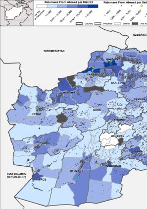
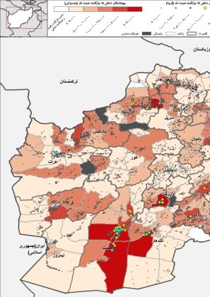
AFG_DTM_June2020_District_Returnees_From_Abroad_Overview_By_District&Villages
This map provides information on Returnees from Abroad Afghans who had fled abroad for at least 6 months and have now returned to Afghanistan During period of 2012 till June 2020
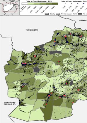
AFG_DTM_June2020_District_Total_Inflow_Overview_By_District&Villages
This map provides information on Total inflow Returnees from Abroad Arrival IDPs during period of 2012 till June 2020
AFG_DTM_June2020_District_Fled_IDPs_Overview_By_District&Villages (دری)
این نقشه مربوط دوره سال ۲۰۱۲ الی جون ۲۰۲۰ است که در مورد بیجاشدگان داخلی که محل اصلی خود را ترک نموده اند میباشد افغان هایکه از یکی از موقعیت های ارزیابی شده به محل دیگری در داخل افغانستان بیجا شده اند

AFG_DTM_June2020_District_Out_Migrants_Overview_By_District&Villages(دری)
این نقشه مربوط دوره سال ۲۰۱۲ الی جون ۲۰۲۰ است و در مورد کسانی است که به خارج از کشور مهاجرت نموده اند افغان هایکه به خارج از کشور نقل مکان نموده اند
AFG_DTM_June2020_District_Arrival_IDPs_Overview_By_District&Villages_(دری)
این نقشه مربوط دوره سال ۲۰۱۲ الی جون ۲۰۲۰ است که در مورد بیجاشدگان داخلی که جابجا شده اند میباشد بیجاشدگان داخلی از موقعیت های دیگر که فعلا در یکی از قریجات ارزیابی شده به سر میبرند
AFG_DTM_June2020_District_Returned_IDPs_Overview_By_District&Villages(دری)
این نقشه مربوط دوره سال ۲۰۱۲ الی جون ۲۰۲۰ است و در مورد بیجاشدگان داخلی قبلی است که دوباره به محل اصلی خود بازگشت نموده اند افغان هایکه از قریجات ارزیابی شده هستند و قبلا محل اصلی خود را منحیث بیجاشدگان داخلی ترک نموده بودند و حال دوباره به خانه هایشان بازگشت نموده اند
AFG_DTM_June2020_District_Returnees_From_Abroad_Overview_By_District&Villages (دری)
این نقشه مربوط دوره سال ۲۰۱۲ الی جون ۲۰۲۰ است و در مورد کسانی از کشور های خارجی بازگشت نموده اند افغان هایکه به حد اقل مدت ۶ ماه خارج از کشور بودند و حال دوباره به وطن بازگشت نموده اند

AFG_DTM_June2020_District_Total_Inflow_Overview_By_District&Villages (دری)
این نقشه مربوط دوره سال ۲۰۱۲ الی جون ۲۰۲۰ است و در مورد مجموعه جریان ورودی است بازگشت کنندگان خارج از کشور بیجاشدگان داخلی که جابجا شده اند
AFG_DTM_June2020_District_Fled_IDPs_Overview_By_District&Villages (پشتو)
دا نقشه د ۲۰۱۲ کال څخه ۲۰۲۰ جون میاشتې اړوند د هغو کورني بېځایه شویو کسانو په اړه ده چ ې خپلې اصلي سیمې یې پریښي هغه افغانان چې له ارزول شویو کلیو څخه د کورنیو بېځایه شویو په توګه یې خپلې سیمې پرېښي او د افغانستان دننه نورو ځایونو کې اوسېږي

AFG_DTM_June2020_District_Arrival_IDPs_Overview_By_District&Villages (پشتو)
دا نقشه د ۲۰۱۲ کال څخه ۲۰۲۰ جون میاشتې اړوند کوربه ټولنو ته راغلیو کورني بېځایه شویو کسانو په اړه ده کورني بېځایه شوي چې له نورو ځایونو څخه یو له ارزول شویو کلیو کې اوسېږي
AFG_DTM_June2020_District_Out_Migrants_Overview_By_District&Villages (پشتو)
دا نقشه د ۲۰۱۲ کال څخه ۲۰۲۰ جون میاشتې اړوند د هېواد څخه بهر ته کډوال شویو کسانو په اړه ده هغه افغانان چې هېواد څخه بهر ته کډوال شوي
AFG_DTM_June2020_District_Returned_IDPs_Overview_By_District&Villages (پشتو)
دا نقشه د ۲۰۱۲ کال څخه ۲۰۲۰ جون میاشتې دورې اړوند د پخوانیو کورنیو بېځایه شویو په اړه ده چې خپلو کورونو ته ستانه شوي هغه افغانان چې له ارزول شویو کلیو څخه دي چې پخوا د کورنیو بېځایه شویو په توګه یې خپلې اصلي سیمې پرېښي وي خو اوس بېرته خپلو کورونو ته ستانه شوي